Teller County
 Teller County Courthouse |
|
| administration | |
|---|---|
| US state : | Colorado |
| Administrative headquarters : | Cripple Creek |
| Foundation : | 1899 |
| Made up from: | El Paso County |
| Demographics | |
| Residents : | 23,350 (2010) |
| Population density : | 16.2 inhabitants / km 2 |
| geography | |
| Total area : | 1448 km² |
| Water surface : | 5 km² |
| map | |
| Website : www.co.teller.co.us | |
The Teller County is a county in the center of the US state of Colorado . The county seat is Cripple Creek .
geography
The county is located in eastern Colorado and has an area of 1,448 square kilometers, of which 5 square kilometers are water. It is bordered clockwise by Counties Douglas to the north, El Paso to the west, Fremont to the south and southeast and Park to the east. The US Highway 24 runs through the County over the Ute Pass .
history
Central Colorado was also the focus of the Colorado Gold Rush in the late 19th century. The so-called Gold Belt Byway , a road connecting different mines , also runs through the county . Today the Gold Belt Byway is a road that offers panoramic views of the rugged terrain.
The county was separated from the west of Pikes Peak in 1899 after the miners there were harassed by the El Paso County's sheriff's men. The miners organized and formed their own "government" in Cripple Creek. Teller County is named after former Colorado Secretary of the Interior, Henry Moore Teller .
Demographic data
| growth of population | |||
|---|---|---|---|
| Census | Residents | ± in% | |
| 1900 | 29.002 | - | |
| 1910 | 14,351 | -50.5% | |
| 1920 | 6696 | -53.3% | |
| 1930 | 4141 | -38.2% | |
| 1940 | 6463 | 56.1% | |
| 1950 | 2754 | -57.4% | |
| 1960 | 2495 | -9.4% | |
| 1970 | 3316 | 32.9% | |
| 1980 | 8034 | 142.3% | |
| 1990 | 12,468 | 55.2% | |
| 2000 | 20,555 | 64.9% | |
| 2010 | 23,350 | 13.6% | |
| 1900-1990
2000 2010 |
|||
As of the 2000 census , the county had 20,555 people. There were 7,993 households and 5,922 families. The population density was 14 inhabitants per square kilometer. The racial the population was composed of 94.92 percent white, 0.55 percent African American, 0.97 percent Native American, 0.58 percent Asian, 0.08 percent of residents from the Pacific island area and 0.90 percent from other ethnic groups Groups; 2.00 percent were descended from two or more races. 3.49 percent of the total population were Hispanic or Latino of any race.
Of the 7,993 households, 33.6 percent had children and young people under the age of 18 living with them. 64.2 percent were married couples living together, 6.6 percent were single mothers. 25.9 percent were not families. 19.6 percent were single households and 4.0 percent had people aged 65 years or over. The average household size was 2.56 and the average family size was 2.94.
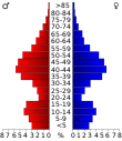
For the entire county, the population was composed of 25.9 percent of residents under 18 years of age, 5.6 percent between 18 and 24 years of age, 31.2 percent between 25 and 44 years of age, 29.8 percent between 45 and 64 years of age 7.5 percent were 65 years of age or over. The median age was 39 years. For every 100 females there were 102.7 males, and for every 100 females aged 18 and over there were 100.9 males.
The median income for a household in the county is $ 50,165 , and the median income for a family is $ 57,071. Males had a median income of $ 37,194 versus $ 26,934 for females. The per capita income was $ 23,412. 5.4 percent of the population and 3.4 percent of families are below the poverty line. This included 6.9 percent of the population under the age of 18 and 4.2 percent of the population aged 65 and over.
Places in Teller County
Individual evidence
- ↑ GNIS-ID: 198175. Retrieved on February 22, 2011 (English).
- ↑ Extract from Census.gov . Retrieved February 28, 2011
- ↑ Excerpt from factfinder.census.gov.Retrieved February 28, 2011
- ^ Extract from census.gov.Retrieved March 31, 2012
Web links
Coordinates: 38 ° 53 ′ N , 105 ° 9 ′ W


