Costilla County
 Costilla County Courthouse |
|
| administration | |
|---|---|
| US state : | Colorado |
| Administrative headquarters : | San Luis |
| Foundation : | November 1, 1861 |
| Demographics | |
| Residents : | 3524 (2010) |
| Population density : | 1.1 inhabitants / km 2 |
| geography | |
| Total area : | 3187 km² |
| Water surface : | 9 km² |
| map | |
| Website : www.costilla-county.com | |
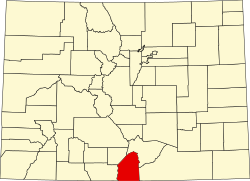
Costilla County [ kəsˈtiːjə ] is a ( county ) in the south of the US state Colorado . The county seat is San Luis .
geography
Costilla County is one of the 16 original counties of Colorado, named after the river of the same name, and lies at the transition from the San Luis Valley to the Sangre de Cristo ( The Blood of Christ ) mountain range . In the west, the Rio Grande (Rio Bravo) - with over 3000 km one of the longest rivers in North America - forms a natural border with the neighboring Conejos . Furthermore, Costilla borders from north to east on the districts of Alamosa , Huerfano and Las Animas and on the New Mexico side on Taos and Colfax .
Demographic data
| growth of population | |||
|---|---|---|---|
| Census | Residents | ± in% | |
| 1870 | 1779 | - | |
| 1880 | 2879 | 61.8% | |
| 1890 | 3491 | 21.3% | |
| 1900 | 4632 | 32.7% | |
| 1910 | 5498 | 18.7% | |
| 1920 | 5032 | -8.5% | |
| 1930 | 5779 | 14.8% | |
| 1940 | 7533 | 30.4% | |
| 1950 | 6067 | -19.5% | |
| 1960 | 4219 | -30.5% | |
| 1970 | 3091 | -26.7% | |
| 1980 | 3071 | -0.6% | |
| 1990 | 3190 | 3.9% | |
| 2000 | 3663 | 14.8% | |
| Before 1900
1900–1990 2000 2010 |
|||


The county had 3,663 people as of the 2000 census . There were 1,503 households and 1,029 families. The population density was 1 person per square kilometer. The racial the population was composed of 60.91 percent white, 0.79 percent African American, 2.48 percent Native American, 1.01 percent Asian, 0.14 percent of residents from the Pacific island area and 29.46 percent from other ethnic groups Groups; 5.21 percent were descended from two or more races. Hispanic or Latino of any race were 67.59 percent of the population.
Of the 1,503 households, 28.5 percent had children and young people under the age of 18 living with them. 52.6 percent were married couples living together, 11.3 percent were single mothers. 31.5 percent were not families. 28.1 percent were single households and 11.6 percent had people aged 65 or over. The average household size was 2.44 and the average family size was 2.98.
For the entire county, the population was composed of 25.0 percent of residents under 18 years of age, 6.6 percent between 18 and 24 years of age, 23.3 percent between 25 and 44 years of age, 28.3 percent between 45 and 64 years of age 16.8 percent were 65 years of age or over. The median age was 42 years. For every 100 females there were 99.8 males, and for every 100 females aged 18 and over there were 96.2 males.
The median income for a household in the county is $ 19,531 , and the median income for a family is $ 25,509. Males had a median income of $ 22,390 versus $ 16,121 for females. The per capita income was $ 10,748. 26.8 percent of the population and 21.3 percent of families are below the poverty line. These included 32.4 percent of the population under the age of 18 and 23.3 percent of the population aged 65 and over.
places
Rivers
- Rio Grande (border river to Conejos County )
mountains
The Costilla district is completely traversed in the west by the Sangre de Cristo Mountains , in which more than a dozen four-thousand-meter peaks lie within the district boundaries .
|
|
|
Web links
Individual evidence
- ↑ GNIS-ID: 198127. Retrieved on February 22, 2011 (English).
- ↑ US Census Bureau - Census of Population and Housing . Retrieved March 15, 2011
- ↑ Extract from Census.gov . Retrieved February 28, 2011
- ↑ Excerpt from factfinder.census.gov.Retrieved February 28, 2011
- ^ Extract from census.gov.Retrieved March 31, 2012
Coordinates: 37 ° 17 ′ N , 105 ° 26 ′ W
