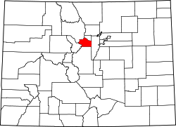
Clear Creek County
 Clear Creek County Courthouse |
|
| administration | |
|---|---|
| US state : | Colorado |
| Administrative headquarters : | Georgetown |
| Address of the administrative headquarters: |
Clear Creek County Courthouse 405 Argentine Street Georgetown, CO 80444-2000 |
| Foundation : | November 1, 1861 |
| Area code : | 001 303 |
| Demographics | |
| Residents : | 9088 (2010) |
| Population density : | 8.9 inhabitants / km 2 |
| geography | |
| Total area : | 1027 km² |
| Water surface : | 3 km² |
| map | |
| Website : www.co.clear-creek.co.us | |

The Clear Creek County [ klɪɹ kɹiːk ], named after the river Clear Creek ( "clear stream"), is a county in the US -amerikanischen State Colorado . In 2010 , the county had 9,088 people and a population density of 8.9 people per square kilometer. By 2013 the population decreased to 9031. The county seat is Georgetown .
geography
Clear Creek County is located in northern central Colorado in the Front Range of the Rocky Mountains , west of Denver . From the northeast (Denver), Interstate 70 meanders through the mountains to the east, in whose catchment area the only larger towns are. On its way to the western county border, it leads through the health resort of Idaho Springs (where the infamous " Oh My God Road " ends when coming from the north ), through the old mining town of Georgetown and finally through the Loveland ski area . The Loveland Pass region is a popular destination for winter sports enthusiasts. The neighboring Summit district, which is reached through the Eisenhower Tunnel , begins a few kilometers behind it .
To the south, Clear Creek County bordering Park County has the greater share of Mount Evans Wildlife Sanctuary .
The following neighboring counties border Clear Creek County:
| Grand County | Gilpin County | |
| Summit County |

|
Jefferson County |
| Park County |
mountains
|
|
Rivers
history
Clear Creek County is one of the 17 counties set up under the foundation of the state in 1861 and is the only one other than Gilpin that is still within its original boundaries. In 1867 the administrative center was moved from Idaho Springs to Georgetown.
population
| Population development | |||
|---|---|---|---|
| Census | Residents | ± in% | |
| 1870 | 1596 | - | |
| 1880 | 7823 | 390.2% | |
| 1890 | 6612 | -15.5% | |
| 1900 | 7082 | 7.1% | |
| 1910 | 5001 | -29.4% | |
| 1920 | 2891 | -42.2% | |
| 1930 | 2155 | -25.5% | |
| 1940 | 3784 | 75.6% | |
| 1950 | 3289 | -13.1% | |
| 1960 | 2793 | -15.1% | |
| 1970 | 4819 | 72.5% | |
| 1980 | 7308 | 51.6% | |
| 1990 | 7619 | 4.3% | |
| 2000 | 9322 | 22.4% | |
| 2010 | 9088 | -2.5% | |
| 2013 estimate | 9031 | -0.6% | |
| Before 1900 1900–1990 2000 2010–2012 | |||
According to the 2010 census , Clear Creek County's 9,088 people lived in 4,013 households. The population density was 8.9 inhabitants per square kilometer. Statistically, 2.23 people lived in each of the 4013 households.
The racial the population was composed of 95.5 percent white, 0.9 percent African American, 1.2 percent Native American, 0.8 percent Asian, 0.1 percent Polynesian and other ethnic groups; 1.6 percent were descended from two or more races. Hispanic or Latino of any race was 5.1 percent of the population.
15.1 percent of the population were under 18 years old, 68.0 percent were between 18 and 64 and 16.9 percent were 65 years or older. 48.3 percent of the population were female.
The median income for a household was 60,517 USD . The per capita income was $ 36,015. 9.8 percent of the population lived below the poverty line.
Clear Creek County localities
Census-designated places (CDP)
|
1 - Part of the Downieville-Lawson-Dumont CDP
There are also several former localities in Clear Creek County, so-called
structure
Clear Creek County is divided into two Census County Divisions (CCD):
| CCD | Population (2010) | FIPS |
|---|---|---|
| Georgetown CCD | 2519 | 08-91463 |
| Idaho Springs CCD | 6569 | 08-91843 |
Individual evidence
- ↑ GNIS-ID: 198125. Retrieved on February 22, 2011 (English).
- ↑ a b c U.S. Census Bureau, State & County QuickFacts - Clear Creek County, CO. Retrieved July 17, 2014
- ↑ a b National Association of Counties.Retrieved July 16, 2014
- ^ US Census Bureau - Census of Population and Housing.Retrieved March 15, 2011
- ^ Extract from Census.gov.Retrieved February 28, 2011
- ↑ Missouri Census Data Center - Colorado ( page no longer available , search in web archives ) Info: The link was automatically marked as defective. Please check the link according to the instructions and then remove this notice. Retrieved July 17, 2014
Web links
Coordinates: 39 ° 41 ′ N , 105 ° 38 ′ W

