
Savognin
| Savognin | |
|---|---|
 |
|
| State : |
|
| Canton : |
|
| Region : | Albula |
| Political community : | Surses |
| Postal code : | 7460 |
| former BFS no. : | 3539 |
| Coordinates : | 765 597 / 163 004 |
| Height : | 1207 m above sea level M. |
| Area : | 22.24 km² |
| Residents: | 1016 (December 31, 2014) |
| Population density : | 46 inhabitants per km² |
| Website: | www.surses.ch |
 Savognin in winter |
|
| map | |
 |
|
Savognin ( German , outdated and officially Schweiningen until 1890 , Rhaeto-Romanic Savognin , in the local dialect Suagnign , Italian , rarely used, Savognino ) was a political municipality in the Albula district of the canton of Graubünden in Switzerland until December 31, 2015 . On January 1, 2016, Savognin merged with the municipalities of Bivio , Cunter , Marmorera , Mulegns , Riom-Parsonz , Salouf , Sur and Tinizong-Rona to form the new municipality of Surses .
The village was the capital of the Surses district .
Savognin is a popular tourist destination in both summer and winter. The official language is the Rhaeto-Romanic idiom Surmiran .
Surname
The meaning of the name is unclear. In 1154 the place was mentioned as Swainingen , 1156 as Suanneng , 1379 Schweining . Suanin , which can be associated with the non-localized Rhaetian tribal name Suanetes, must be assumed as the initial form . The name Sevgein is of the same origin.
geography
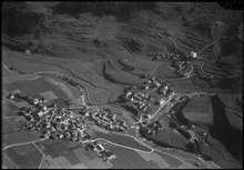
Savognin is located in the middle of the wide Sotgôt basin , the lower part of the Surses valley (Eng. Oberhalbstein ).
The former municipal area comprised a section of the main valley between the Piz Arblatsch (3203 m, highest point of the municipality) in the southwest and the Piz Mitgel (3159 m) in the northeast. As the three old churches testify, the village arose from several cores: on the Julia River , on the gently rising slope on the left and along the main road that rises on the right. The heavy building activity between 1965 and 1975 closed the gaps between the parts of the village and also significantly expanded the settlement area on the right side of the valley.
In 1997, 32.7% of the former municipal area was used for agriculture, the forest took up 36.2% and the settlements 3.0%. 28.2% were considered unproductive.
Neighboring communities were Cunter , Albula / Alvra , Filisur , Tinizong-Rona , Mulegns and Riom-Parsonz .
history
An important Bronze Age settlement was located on the Padnal hill south of the town . Finds recovered in several excavations show village complexes from different epochs, between 1800 and 1000 BC. A little higher than Padnal lies the Rudnal site , which is believed to be a prehistoric refuge .
Important transit routes have led over the Julier and Septimer passes at least since Roman times . Savognin came into the possession of the bishop in the 13th century . As part of the Oberhalbstein court, the capital and parish of which Savognin developed, the place became a member of the Church of God . With the ransom in 1552, the valley gained full sovereignty within the Free State of the Three Leagues .
Since the Middle Ages, livestock farming and pass traffic have formed the economic basis. After the boom - for example after the Crap Ses was blown up in 1777 and the Julierstrasse was expanded between 1820 and 1840 - setbacks followed again and again, most recently due to the overwhelming competition of the Gotthard Railway, which opened in 1882 . Savognin was thrown back on the level of a farming village and initially missed the connection to the tourist development. In the middle of the 19th century, Yenish families were naturalized on the basis of the law to combat homelessness . It was not until 1960 that it began to become a tourist destination, with the construction of hotels, holiday apartments and cable cars permanently changing the appearance of the town.
Savognin became known, especially among competitors within the Graubünden region, for its first large-scale use of snow cannons from 1978.
coat of arms


Blazon : red, divided by a silver-bordered blue river ribbon, two at the top and a silver bell at the bottom.
The coat of arms symbolizes the location on the river and the three churches of the village.
population
| Population development | |||||||||||||
|---|---|---|---|---|---|---|---|---|---|---|---|---|---|
| year | 1643 | 1710 | 1802 | 1850 | 1900 | 1950 | 1960 | 1970 | 1980 | 1990 | 2000 | 2005 | 2014 |
| Residents | 430 | 530 | 365 | 469 | 444 | 766 | 632 | 820 | 852 | 877 | 882 | 982 | 1016 |
languages
The original language of the locals is Surmeir , a regional dialect of Rhaeto-Romanic . The community was almost monolingual both in 1880 with 96.2% and in 1910 with 91.61% Romansh speakers. This value then fell to 81.1% by 1941. Since then, Romansh has been losing ground massively through immigration and, since 1980, through language changes. In 1970, 66.59% were Romansh, today around half of the population. The following table shows the development over the past decades:
| Languages in Savognin | ||||||
| languages | 1980 census | 1990 census | 2000 census | |||
| number | proportion of | number | proportion of | number | proportion of | |
| German | 212 | 24.88% | 274 | 31.24% | 323 | 36.62% |
| Romansh | 562 | 65.96% | 546 | 62.26% | 468 | 53.06% |
| Italian | 42 | 4.93% | 25th | 2.85% | 32 | 3.63% |
| Residents | 852 | 100% | 877 | 100% | 882 | 100% |
Romansh is still understood by 70.1% of the population and is the only official language.
Origin and nationality
Of the 982 residents at the end of 2005, 854 (= 86.97%) were Swiss citizens.
economy
As the seat of the district administration, district hospital and secondary school, Savognin forms the center of the valley. 71 people were employed in agriculture, 122 in manufacturing and 423 in the service sector.
The most important branch of business is tourism with around 200,000 overnight stays per year. Several Savognin Bergbahnen cable cars open up the ski areas on Piz Martegnas and in Val Nandro . The Lai Barnagn is dammed up as a bathing lake in the parking lot of the cable car in summer and warms up quickly to pleasant bathing temperatures, which is why it is one of the warmest bathing lakes in the Alps. Savognin is the transit point and (since 2013) the starting point of the Swiss Irontrail mountain run .
traffic
Savognin is located on the main road 3 from Chur via Lenzerheide and Julier Pass into the Engadin . A post bus line also runs on this route . Most courses end in Bivio , some of them go as far as St. Moritz . There is another post bus connection to the surrounding villages of Riom , Parsonz and Salouf.
Attractions

Savognin has three Catholic churches from the baroque period :
- The parish church of Nossadonna (Mary Conception) was consecrated in 1643, the external appearance is based on Gothic models, the painting dates from 1663.
- The Son Martegn church is a new building from 1677; the central building with a cruciform floor plan contains a monumental ceiling painting from 1681 by the painter Carlo Nuvolone from Milan .
- The Son Mitgel church was rebuilt in 1663; the octagonal central building with an older tower contains altars from 1693/94 inside.
The Reformed Church of Savognin is a modern sacred building .
Furthermore, some stately town houses are worth seeing, such as
- the Peterelli house on the main street,
- the Amilcar house near the parish church, with half-timbering influenced by southern Germany, and
- The house (museum), a farmhouse from the 16th century in which a regional museum was established in 1982.
The Juliabrücke in the Sot Curt part of the village dates from 1682.
The Hotel Cube by architects Carlo Baumschlager and Dietmar Eberle is the youngest building worth seeing, but it has been closed since autumn 2018.
Surroundings of Savognin
To the west above Savognin, on the slope of Piz Curvér, stands the Ziteil pilgrimage church (highest in the Eastern Alps).
Personalities

The painter Giovanni Segantini lived in Savognin from 1886 to 1894 and developed his own style there. His landscapes with the Piz Curvér and Piz Toissa mountains in the background became famous . The “Senda Segantini” hike, which lasts several days, combines stations from the painter's life.
Barbara Uffer (1873–1935), the nanny of the painter's family, was also his model and one of the most important people in his life and work. She was born in Savognin.
The trade diplomat Luzius Wasescha , who as ambassador represented Swiss economic interests to the World Trade Organization (WTO) , is entitled to live in Savognin. He had arranged for the second round of negotiations on the free trade agreement between Switzerland and Japan to be held in the Savognin village school in July 2007 .
literature
- Erwin Poeschel : The art monuments of the canton of Graubünden III. The valley communities Räzünser Boden, Domleschg, Heinzenberg, Oberhalbstein, Upper and Lower Engadine. (= Art Monuments of Switzerland. Volume 11). Edited by the Society for Swiss Art History GSK. Bern 1940. DNB 760079625 .
- Jürg Rageth, Jürg Simonett: Savognin. In: Historical Lexicon of Switzerland . 2016 .
Web links
- Savognin on the ETHorama platform
- Official website of the municipality of Savognin
Individual evidence
- ↑ Andrea Schorta : How the mountain got its name Terra Grischuna Verlag, Chur 1999
- ^ Andrea Schorta: Rätisches Namenbuch, Volume II Etymologies (1985), p. 829
- ^ Catholic parish church of the Conception of Mary
- ↑ Old Catholic parish church of St. Martin
- ^ Catholic Church of St. Michael
- ↑ Amilcar House
- ↑ Residence (museum)
- ^ Hotel Cube
- ↑ Hiking in Switzerland in the footsteps of Giovanni Segantini through Savognin, Graubünden ( Memento of the original from March 14, 2015 in the Internet Archive ) Info: The archive link has been inserted automatically and has not yet been checked. Please check the original and archive link according to the instructions and then remove this notice.
- ↑ The diplomats negotiate in the village school building
Albula / Alvra | Bergün Filisur | Lantsch / Lenz | Schmitten | Surses | Vaz / Obervaz
Former municipalities: Alvaneu | Alvaschein | Bergün / Bravuogn | Bivio | Brienz / Brinzauls | Cunter | Filisur | Laces | Marmorera | Mon | Mulegns | Parsonz | Riom | Riom-Parsonz | Rona | Salouf | Savognin | Stierva | Stugl | Sur | Surava | Tiefencastel | Tinizong | Tinizong-Rona | grasslands
Canton of Graubünden | Regions of the Canton of Graubünden | Municipalities of the Canton of Graubünden