
Trier-Palatinate
|
Pfalzel
City of Trier
|
|
|---|---|
 |
|
| Height : | 131 m above sea level NHN |
| Area : | 2.38 km² |
| Residents : | 3585 (Dec. 31, 2017) |
| Population density : | 1,503 inhabitants / km² |
| Incorporation : | 7th June 1969 |
| Postal code : | 54293 |
| Area code : | 0651 |
  Location in the city of Trier
|
|
Pfalzel is one of the 19 districts of the city of Trier in Rhineland-Palatinate .
geography
Spatial location
Pfalzel is located in the northeast of the city west of the Moselle . It has about 3500 inhabitants.
Similar to the opposite district of Ruwer , Pfalzel is located in the flood area of the Moselle. For some years now, a partially mobile flood protection system for quick installation has been protecting houses on the Moselle up to a level of over eleven meters. The massive protective gates on the Moselle Cycle Path cannot be overlooked.
Pfalzel refers to the table sheet No. 6206 (formerly No. 3477) of the topographic map on a scale of 1: 25,000.
Neighboring boroughs
history


Hardly any of the previously independent districts of Trier can look back on a history as diverse as Pfalzel. The name goes back to the Latin word " palatiolum " (= small palace) and was originally the name for a palatial castle complex from the 4th century, which was very likely closely related to the imperial court in Trier. Some of the walls of the complex that have been preserved to this day extend to the second floor.
In the 7th century a nunnery was founded in the building, which was converted into a canons' monastery in 1027. The Stiftsbering was supplemented with a gatehouse, cloister, chapels and farm buildings. Up to the 16th century, the castle and monastery were surrounded by an impressive rampart wall that has been preserved to this day and supplemented by a tithe barn, an Electorate of Trier district, a mint and a mill.
Under Archbishop Albero von Montreuil (1131-1152) the construction of a castle complex in the western part of the Palatiolum began. A previous castle building cannot be grasped from the written sources. The Palatinate Castle repeatedly served the Archbishops of Trier as an alternative and “counter residence” when there were disputes with the Trier municipality.
A civil rural settlement developed in the vicinity of the castle, which, secured by its own defensive wall, was granted town charter in 1346. During the campaigns of Louis XIV , who occupied Trier in 1673, the fortifications of Pfalzel were gradually razed.
The Office Pfalzel included in Kurtrier time 54 villages around Trier.
In the Prussian period from 1815, Biewer and Ehrang belonged to the mayor's office of Pfalzel . Biewer was separated in 1930 and incorporated into Trier, but Pfalzel initially remained independent.
On March 1, 1968, the two independent communities Ehrang and Pfalzel were merged into one large community . Only one year later, however, on June 7, 1969, the Ehrang-Pfalzel community was incorporated into the city of Trier. Pfalzel and Ehrang / Quint have been districts of the city of Trier since then.
politics
Local advisory board
A local district was formed for the Pfalzel district . The local council has 13 members, the chair of the local council is chaired by the directly elected mayor.
Since the local elections on May 26, 2019, the Independent Citizens' Representation Trier (UBT) has been the strongest member of the local council with six seats . The SPD follows with five seats and the CDU with two.
For more information and historical data, see the results of the local elections in Trier .
Mayor
The mayor of Pfalzel has been Margret Pfeiffer-Erdel ( FWG, later UBT ) since July 15, 2014 . In the direct election on May 26, 2019, she was confirmed in her office with a share of 76.27% of the votes.
Attractions
The district has numerous historical buildings:
- the circular wall (largely preserved city fortifications), especially the artillery wall with six roundels that was built in the 1530s
- the collegiate church above the southeast corner of the palatolium
- allegedly the oldest inhabited stone house in Germany
- Remains of the episcopal castle (gate tower in the western wall of the fortification)
- former Electoral Trier administrative building (16th century)
- former nunnery, founded around 710 (later in the 12th century canons' monastery)

The allegedly oldest inhabited stone house in Germany
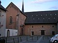
Collegiate church

Saint Martin Church
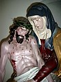
Pieta in the Marienkapelle in the Pfalzeler Straße
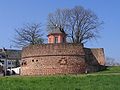
Wall wall

View from the wall with Ruwer in the background


Furthermore, a technically remarkable hot air water pump can be seen on the playground .
In its local plan and in the existing buildings, Pfalzel has preserved all the elements that reveal the continuous settlement since late antiquity and growth through the centuries. Around the Roman palace complex, the collegiate church and the episcopal castle, the streets and alleys are lined with houses that show the diversity of architectural styles from the Renaissance period to today. Of the six mighty bastions of the ramparts, the Moselle bastion is still very well preserved today.
Infrastructure and economy
traffic
The tariff of the Verkehrsverbund Region Trier (VRT) applies to all local public transport (ÖPNV ) . In local transport in Trier , line 7 connects Pfalzel with Trier every 30 minutes, from Monday to Friday, from where you can reach all stops and towns. At night and on weekends, line 87 runs on the same route, also every 30 minutes.
Motorway connections to the federal motorways A602 , A64 and A1 are in the immediate vicinity. The city center of Trier can be reached by car in around 15 minutes. Since April 2007, with the opening of a new section of federal highway 53, a bypass of the districts of Biewer and Ehrang has existed.
The Pfalzel train station is located on the Eifelbahn in the direction of Gerolstein and the Moselle route to Wittlich - Koblenz . The following local rail passenger lines operate :
| line | designation | Line course | Clock frequency |
|---|---|---|---|
| RB 22 | Eifel Express |
Cologne Fair / Deutz - Cologne - Euskirchen - Jünkerath - Gerolstein - Bitburg-Erdorf - Ehrang - Pfalzel - Trier
(Cologne Fair / Deutz - Gerolstein as RE 22) |
60 min
(in the HVZ repeater trains to Gerolstein / Jünkerath) |
| RB 81 | Moselle Valley Railway | Koblenz - Cochem - Bullay (DB) - Wittlich - Pfalzel - Trier | 60 min |
| RB 83 | Wittlich - Pfalzel - Trier - Wasserbillig - Sandweiler-Contern - Luxembourg | 60 min
(Wittlich - Trier only Mon-Sat) |
The next long-distance connections are in Koblenz Hbf , Saarbrücken Hbf and Luxembourg .
The Pfalzel railway bridge over the Moselle is of great importance in terms of traffic, as it is used to carry all rail traffic between Cologne / Koblenz and Trier.
economy
- Pfalzel is in close proximity to the port of the city of Trier, where numerous companies and industry have settled.
- On the outskirts of Pfalzel there is a large factory of the Michelin company .
Schools and kindergartens
- Gregor von Pfalzel Primary School Trier (Pfalzgrafenstraße)
- Mäusheckerweg school center ( G8 grammar school and secondary school plus )
- Daycare center St. Adula (Hans-Adamy-Straße)
Personalities of the place
- Adula von Pfalzel (around 660–735), founder of the monastery
- Johannes von Paltz (around 1445–1511), theologian and preacher, born in Pfalzel
- Heinrich Oberhoffer (1824–1885), composer, musicologist, instrumental pedagogue, cathedral organist in Luxembourg, born in Pfalzel
- Wilhelm Backes (1921–1991), member of the state parliament of the SPD, born in Pfalzel
- Günther Steines (1928–1982), track and field athlete, born in Pfalzel
- Bert Steines (1929–1998), track and field athlete, born in Pfalzel
- Bernhard Kaster (* 1957), CDU politician
literature
- Ulrike Weber (arrangement): City of Trier. City expansion and districts. (= Cultural monuments in Rhineland-Palatinate. Monument topography Federal Republic of Germany . Volume 17.2 ). Wernersche Verlagsgesellschaft, Worms 2009, ISBN 978-3-88462-275-9 , p. 348 ff .
- Andrea Bidinger (Ed.): Pfalzel. Past and present . Working group Pfalzeler Chronik, Pfalzel 1989.
- Heinz Cüppers , From the Roman Palace to the Parish Church in New Trierisches Jahrbuch 1964, page 9 ff.
Web links
- Trier-Pfalzel at www.trier.de
- Historical postcard collection from Pfalzel
- Pfalzelarchiv.de: Magazine on the history of the Pfalzel district of Trier
- Website of the Pro Pfalzel e. V.
- Private website about the municipality
Individual evidence
- ^ Deutsche Fotothek : Mes table sheet No. 3477: Pfalzel, 1887
- ↑ landkartenarchiv.de: Mes table sheet No. 6206: Pfalzel, 1940
- ↑ Map 2019, DNB 1190334844
- ↑ Official municipality register 2006, State Statistical Office Rhineland-Palatinate ( Memento from December 31, 2016 in the Internet Archive ), p. 198 (PDF; 2.6 MB) (Internet archive )
- ^ City of Trier: main statute. (PDF) § 2 to June 6, 2017, accessed on October 22, 2019 .
- ^ City of Trier - mayor / local advisory board. Accessed July 31, 2019 .
- ^ The Regional Returning Officer Rhineland-Palatinate: Direct elections 2019. Trier, independent city, see fifth row of results. Retrieved October 22, 2019 .

Biewer | Ehrang / Quint | Your | Feyen / Weismark | Filsch | Holy Cross | Irsch | Kernscheid | Kürenz | Mariahof | Center / garden field | North | Olewig | Pfalzel | Ruwer / Eitelsbach | South | Tarforest | West / Pallien | Zewen