
Robawy
| Robawy | |||
|---|---|---|---|

|
|
||
| Basic data | |||
| State : | Poland | ||
| Voivodeship : | Warmia-Masuria | ||
| Powiat : | Kętrzyn | ||
| Gmina : | Reszel | ||
| Geographic location : | 54 ° 2 ' N , 21 ° 9' E | ||
| Residents : | 143 (2011) | ||
| Postal code : | 11-440 | ||
| Telephone code : | (+48) 89 | ||
| License plate : | NKE | ||
| Economy and Transport | |||
| Street : | Ext. 590 : Biskupiec - Łężany ↔ Reszel - Korsze - Barciany | ||
| Ext. 593 : Miłakowo - Dobre Miasto - Jeziorany - Mnichowo ↔ Reszel | |||
| Ext. 594 : Bisztynek - Reszel ↔ Święta Lipka - Kętrzyn | |||
| Rail route : | no rail connection | ||
| Next international airport : | Danzig | ||

Robawy ( German Robawen , 1938–1945 Robaben ) is a village in Poland in the Warmian-Masurian Voivodeship . It belongs to the Gmina Reszel ( urban and rural community Rößel ) in the powiat Kętrzyński ( Rastenburg district ).

Geographical location
Robawy is located in historic East Prussia about one kilometer south of Reszel ( Rößel ) and four kilometers northwest of Święta Lipka ( Heiligelinde ). It is 15 kilometers to the northeast to the district town of Kętrzyn ( German Rastenburg ).
history
Local history
The widely scattered village was localized on September 6, 1363 by the Warmian bishop Johann II. Stryprock ( Jan Stryprock in Polish ) according to Kulmer law . The village name was Borgholcz when it was founded . In 1733 the Markuszewski family foundation had a baroque chapel built. In 1783 there were 36 houses in the village, in 1820 the number had dropped to 28. The name Robawen originated in the 18th century .
From 1874 to 1945, the village with the living quarters was Lindenberg (Polish Lipowa Góra ), Lindenthal Krug (Karczmarka) and Waldau (Wałdowo) in the District Klawsdorf ( Polish Klewno ) incorporated
Due to the provisions of the Versailles Treaty , the population voted in the referendums in East and West Prussia on July 11, 1920 on whether they would continue to belong to East Prussia (and thus Germany) or join Poland. In Robawen, 380 people voted to remain with East Prussia, while Poland did not.
On September 30, 1928, Robawen expanded to include the neighboring towns of Ramten (Ramty) and Rheindorfshof (Wólka Ryńska) , which were incorporated. On June 3 (officially confirmed on 16 July) 1938 Robawen in "Robaben" was renamed .
In 1945, at the end of World War II , the Red Army marched into the area. As a result of the war, the village became part of Poland as “Robawy”. On January 1, 1955, the village became the seat of a Schulzenamt ( Polish Sołectwo ), which belonged to the Gromada Mnichowo . In 1957 this Gromada was dissolved and Robawy became part of the Gromada and from 1972 the municipality of Reszel. The village formed a Schulzenamt to which the localities Kocibórz ( German Kattmedien ), Lipowa Góra (Lindenberg) and Ramty (Ramten) belonged.
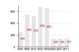
Population development
The following is a graphic representation of the population development.
Attractions
St. Anne's Chapel

In the village there is a chapel built in 1733 , which was expanded in 1929. The chapel was built in the Baroque style and housed a Pietà from 1671 or 1771. It is a copy of an older Gothic sculpture and is now in Reszel. The chapel is only open to visitors once a year, on July 26th.
church
Until 1945 Robawen (Robaben) was parish in the Protestant church Rößel in the church province of East Prussia of the Church of the Old Prussian Union and in the Catholic parish of Rößel in the diocese of Warmia . The connection to the Catholic Church in Reszel, but now in the Archdiocese of Warmia , has remained. The Protestant church members, however, are oriented towards the parish of Kętrzyn in the Masurian diocese of the Evangelical Augsburg Church in Poland .
traffic
Street
Robawy is on the voivodeship roads DW 590 and DW 593 .
The 590 and 593 unite west of the village and then flow into the voivodship road 594 on the eastern edge of Robawy . The crosses 593 after about 20 kilometers south at Lutry (Kaiserslautern) the country Straße 57 .
The DW 590 runs south and ends after 25 kilometers in Biskupiec (Bischofsburg) with the confluence with the state road 57. In the north it joins briefly with the DW 594 and then runs through Reszel , Korsze (Korschen) and Wilkowo Wielkie (Groß Wolfsdorf) to the confluence with Voivodship Road 591 north of Barciany (Barten) .
The provincial road 594 runs to Reszel and turns there to the west and finally after about 20 kilometers at Bisztynek (Bischofstein) into the state road 57. In the opposite direction, it first runs south-east and turns after five kilometers at Święta Lipka (Heiligelinde) to the east and ends after 15 kilometers in Kętrzyn ( Rastenburg ).
rail
Robawens was only connected to rail traffic through the station in Rößel until 1945.
air
The geographically closest international airport is Kaliningrad Airport , which is located about 100 kilometers northwest on Russian territory and thus outside the European Union. The nearest international airport on Polish territory is Lech Walesa Airport in Gdansk, about 180 kilometers to the west .
literature
- Tadeusz Swat: Dzieje wsi . In: Aniela Bałanda and others: Kętrzyn. Z dziejów miasta i okolic , Pojezierze, Olsztyn 1978, p. 219 ( Seria monografii miast Warmii i Mazur ).
Web links
Individual evidence
- ↑ Polish Postal Code Directory 2013, p. 1078
- ↑ Dietrich Lange, Geographical Location Register East Prussia (2005): Robaben
- ↑ a b c d e Swat 1978, p. 219
- ↑ Rolf Jehke, District Klawsdorf .
- ↑ Herbert Marzian , Csaba Kenez : self-determination for East Germany. Documentation on the 50th anniversary of the East and West Prussian referendum on July 11, 1920. Editor: Göttinger Arbeitskreis , 1970, p. 109
- ↑ a b Robawen at GenWiki
- ↑ Kętrzyn. Z dziejów miasta i okolic , Olsztyn, 1978, p. 301.
-
↑ For 1820 and 1939: Swat 1978, p. 219
1910 - Informacje ogólne - Robawy . Archived from the original on March 1, 2005 ; Retrieved October 8, 2017 (Polish). 1933: Michael Rademacher: German administrative history from the unification of the empire in 1871 to the reunification in 1990. Rössel district (Polish Reszel). (Online material for the dissertation, Osnabrück 2006). 2005 - website of the city of Reszel, Reszel - ciekawostki historyczne , 20 Aug 2007
- ↑ a b Informacje ogólne - Robawy . Archived from the original on March 1, 2005 ; Retrieved October 8, 2017 (Polish).
- ^ Wieś Robawy w liczbach
- ↑ a b Website of the city of Reszel, Reszel - ciekawostki historyczne , Aug. 20, 2007 ( WebCite ( Memento from February 15, 2009 on WebCite ))
- ↑ Walther Hubatsch , History of the Protestant Church of East Prussia , Volume 3 Documents , Göttingen 1968, p. 490

City: Reszel (Rößel)
Villages and school offices : Bezławki (Bäslack) | Czarnowiec (Schwarzenberg) | Dębnik (Damerauwald) | Klewno (Klawsdorf) | Kocibórz (Kattmedien) | Leginy (Legien) | Łężany (Loszainen / Loßainen) | Mnichowo (Groß Mönsdorf) | Pieckowo (Pötschendorf) | Pilec (Pülz) | Plenowo (Plönhöfen) | Ramty (Ramten) | Robawy (Robawen / Robaben) | Siemki ( Scharfs ) | Święta Lipka (Holy Linden Tree) | Tolniki Małe (Tollnigk) | Widryny (Widrinnen) | Wola (Dürwangen) | Worpławki (Worplack) | Zawidy (Soweiden)
Other localities: Bertyny (Bertienen) | Bezławecki Dwór (Bäslackshof) | Biel (Weissensee) | Grodzki Młyn (Castle Mill) | Grzybowo (Mirror Korschen) | Kępa Tolnicka (Atkamp) | Łabędziewo (Labendzowo / Schwanau) | Lipowa Góra (Lindenberg) | Mała Bertynówka | Mojkowo (Annahof) | Niewodnica (Fischbach) | Pasterzewo (Pastern) | Pudwągi (Posewangen) | Śpigiel (mirror) | Śpiglówka (Spieglowen / Spiegelswalde) | Staniewo (Ottoswalde) | Stąpławki (Nobleman Stumplack) | Wanguty (Wangotten) | Wólka Pilecka ( Stechernsruh ) | Wólka Ryńska (Rheindorfshof)