Saone
| Saone | ||
|
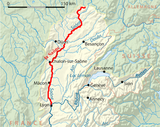
Course of the Saône |
||
| Data | ||
| Water code | FR : U --- 0000 | |
| location | France , Grand Est regions , Bourgogne-Franche-Comté and Auvergne-Rhône-Alpes | |
| River system | Rhône | |
| Drain over | Rhône → Mediterranean | |
| source | at Vioménil 48 ° 5 '32 " N , 6 ° 10' 47" E |
|
| Source height | approx. 405 m | |
| muzzle | near Lyon in the Rhone coordinates: 45 ° 43 '42 " N , 4 ° 49' 7" E 45 ° 43 '42 " N , 4 ° 49' 7" E |
|
| Mouth height | approx. 161.8 m | |
| Height difference | approx. 243.2 m | |
| Bottom slope | approx. 0.51 ‰ | |
| length | 473 km | |
| Catchment area | 29,900 km² | |
| Outflow at the Couzon-au-Mont-d'Or gauge |
MQ |
480 m³ / s |
| Big cities | Lyon | |
| Medium-sized cities | Chalon-sur-Saône , Mâcon , Villefranche-sur-Saône | |
| Small towns | Tournus | |
| Navigable | from the mouth to Corre | |
|
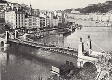
Saône in Tournus |
||
The Saône [ soːn ] is a river in eastern France , in the Grand Est , Bourgogne-Franche-Comté and Auvergne-Rhône-Alpes regions . It generally drains south-west to south and flows into the Rhône after 473 kilometers . Its course is divided into the Upper, Small and Large Saône.
geography
course
The Saône rises west of the Vosges in the Vosges department at 405 m in Vioménil . The spring emerges in a channel and feeds two water basins in a washhouse below . Immediately after its source, the Upper Saône runs west through a forest to Bonvillet . From there it first flows to the southwest and forms a large, narrow river bend in Monthureux-sur-Saône . At Châtillon-sur-Saône it changes its direction of flow to the southeast and reaches the border with the Haute-Saône department at Jonvelle . South of Corre , the Saône meets the Côney tributary and the Canal des Vosges after about 70 km . The Saône is navigable from its confluence and is called the Little Saône.
Subsequently, puncture canals separated from the natural course of the Saône were created in numerous places in order to shorten larger river loops for navigation (see section on shipping ). There are locks in most of these canals . At Conflandey it joins the Lanterne , at Heuilley-sur-Saône after about 215 km the Ognon of about the same length . There the Saône crosses the border to the Côte-d'Or department . After reaching the Saône-et-Loire department , the Saône flows into its largest tributary, the Doubs, after a good 300 km . It is about 150 km longer than the Saône at this point and richer in water (Doubs: 173 m³ / s, Saône: 160 m³ / s). From there on it is called the Great Saône.
From the mouth of the Seille the Saône forms the border with the department of Ain and reaches north of Belleville , the Rhône region of France . In Lyon it flows into the Rhône as a right tributary .
Places on the river
- Gray
- Saint-Jean-de-Losne
- Chalon-sur-Saône
- Tournus
- Mâcon
- Villefranche-sur-Saône
- Caluire-et-Cuire
- Lyon
Tributaries
Downstream sequence:
|
Left tributaries: |
Right tributaries: |
A comprehensive listing of all tributaries can be found in the list of tributaries of the Saône .
history
The river is mentioned in various places in Gaius Iulius Caesar's work De bello Gallico , especially in relation to the emigration of the Helvetii towards the Santonen .
shipping
The Saône is canalised over a length of 407 km between Corre and its confluence with the Rhône and is therefore navigable by ships. The canalized route includes a number of punctures and abbreviations and is therefore effectively only 365 km.
The canalized part of the Saône can be divided into two sections:
- From Corre to the Auxonne lock
- 19 locks ( Freycinet class : with inconsistent dimensions)
- Draft 1.80 m
- Minimum clearance height 3.50 m
- There are two tunnels in this section, one at Saint-Albin (km 48, 681 m long, 6.55 m wide - Monument historique ), another at Seveux and Savoyeux (km 76, 643 m long, 6.50 m) wide); In both tunnels and on the stretches in front of the tunnel entrances, there is a one-way control system controlled by signal lights.
- Below the Auxonne lock to Lyon (large shipping route)
- 5 locks, (Seurre, Écuelles, Ormes, Dracé, Couzon) (185 × 12 m)
- Draft 3 m
- Minimum clearance 6 m
The Saône forms the backbone of the French waterway network; important canals that connect them with other river basins flow into them:
- Canal des Vosges (at the start of the navigable route)
- Canal entre Champagne et Bourgogne (at km 127)
- Canal du Rhône au Rhin (at km 160)
- Canal de Bourgogne (at km 165)
- Canal du Center (at km 221)
See also
Web links
Individual evidence
- ↑ a b geoportail.fr (1: 16,000) using the "Altimetry" function
- ↑ a b The information on the length of the river is based on the information on the Saône from SANDRE (French), accessed on October 6, 2010, rounded to the nearest kilometer.
- ↑ a b Banque Hydro - Station U4710010 (menu item: Synthèse)
- ↑ Caesar - De bello Gallico 1.11-1.15: Defeat of the Tigurines. Negotiations and first enemy contact with the Helvetians. Retrieved May 22, 2019 .
- ↑ Canal souterrain de Saint-Albin in the Base Mérimée of the French Ministry of Culture (French)


