
Stirling (Council Area)
| Stirling Sruighlea |
|
|---|---|
  |
|
| Administrative headquarters | Stirling |
| surface | 2,187 km² (9.) |
| Residents | 91.020 (2012) (24.) |
| ISO 3166-2 | GB-STG |
| ONS code | 00RG |
| Website | www.stirling.gov.uk |
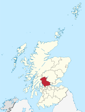
Stirling ( Gaelic Sruighlea ) is one of 32 Council Areas in Scotland . It borders Argyll and Bute , Clackmannanshire , East Dunbartonshire , Falkirk , North Lanarkshire , Perth and Kinross and West Dunbartonshire .
A little more than two thirds of the population lives in the southeast corner of the borough, in the city of Stirling and in the surrounding towns of the Central Lowlands . These include Dunblane and Bridge of Allan in the north, Bannockburn in the south and the three former coal mining settlements of Cowie, Fallin and Plean in the east (collectively referred to as "The Eastern Villages").
The remaining 30% of the population live scattered in the vast rural part of this administrative district. The southern half comprises the flat alluvial plain of the River Forth , bounded in the south by the Touch Hills and Campsie Fells . To the north of the valley stretch the mountains of the Trossachs and the hills of the Highlands .
places
Attractions
politics
The Stirling Council has 23 seats, which are distributed among the parties as follows:
| Political party | Seats |
|---|---|
| Scottish National Party | 9 |
| Conservative | 9 |
| Labor | 4th |
| Green | 1 |
Individual evidence
- ↑ Mid-2012 Population ( Memento from November 29, 2014 in the Internet Archive ) (PDF; 1.2 MB)
- ↑ Results of the regional elections 2017
Web links
Aberdeen | Aberdeenshire | Angus | Argyll and Bute | Clackmannanshire | Dumfries and Galloway | Dundee | East Ayrshire | East Dunbartonshire | East Lothian | East Renfrewshire | Edinburgh | Falkirk | Fife | Glasgow | Highland | Inverclyde | Midlothian | Moray | Outer Hebrides | North Ayrshire | North Lanarkshire | Orkney | Perth and Kinross | Renfrewshire | Scottish Borders | Shetland | South Ayrshire | South Lanarkshire | Stirling | West Dunbartonshire | West Lothian