Stirling Range National Park
| Stirling Range National Park | ||
|---|---|---|
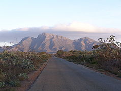
| Bluff Knoll in the Stirling Range National Park | ||
|
|
||
| Location: | Western Australia , Australia | |
| Specialty: | Sandstone mountains, orchids | |
| Next city: | 90 km from Albany | |
| Surface: | 1,159 km² | |
| Length: | 65 km | |
| Founding: | 1913 | |
| Visitors: | 90,000 (1998) | |
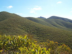
| Heathland in the Stirling Range National Park | ||
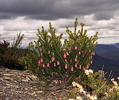
| Darwinia leiostyla | ||
The Stirling Range National Park (English Stirling Range National Park ) is a 1,159 square kilometer park in the southwest of Western Australia , Australia .
location
The park is located approximately 90 kilometers north of Albany and 340 km southeast of Perth . Here two mountain ranges rise from the large southern agricultural level of Western Australia: the smaller Porongurup Range, further south, with the national park of the same name, and the significantly larger Stirling Range in the north, which reaches heights of more than 1,000 meters. The rugged mountain range extends over a length of 65 kilometers in an east-west direction. At 1095 m , the Bluff Knoll is the highest elevation in the park and therefore also in the south of Western Australia. It is one of the few places in Western Australia that sometimes does snow.
geology
The rocks in this area were formed by sand and clay deposits in a river delta. Over millions of years these layers became thicker and heavier, so that together with the forces in the earth's crust, the entire area sank. This in turn allowed more sediments to deposit on the surface, and the layer continued to grow in thickness. The sediments are believed to have reached a total thickness of 1.6 kilometers during this process. Due to the high pressure and the temperature in the deeper layers, the water was squeezed out and solidified into sandstone and slate .
Later this formation rose again over the course of millions of years. This exposed the rocks to weathering and erosion . This constant influence of wind, water and gravity, together with chemical conversion, created the current shape of the Stirling Range.
history
The Aboriginal tribes of the Mineng , Nyoongar and Goreng originally lived in and around the Stirling Range. Bluff Knoll was called by them Bular Mial (to German many eyes ) or Bala Mial (to German his eyes ), because the rock formations are reminiscent of the eyes of the ancestral spirits .
The mountain range was first described by Matthew Flinders in 1802. In 1831 the doctor Alexander Collie mentioned the Aboriginal name, Koi Kyeunu-ruff , in his notes. Named after the Stirling Range, as General John Septimus Roe with Governor Sir James Stirling traveled to Perth in 1835 and some remarkable and elevated peaks (Engl. Some remarkable and lofty summit ) saw. Roe called it the Stirling Range. The area was declared a national park as early as 1913.
flora
The Stirling Range National Park is one of the world's most important areas for the diversity of plant species. More than 1,500 plant species are native to the national park, which is more than, for example, found in the British Isles . 87 of these plant species are endemic , including the two Darwinia species Wittwer's Mountain Bell ( Darwinia wittwerorum ), this species is considered "Endangered" = "endangered", and Success Bell or Red Mountain Bell ( Darwinia nubigena ), this species is considered to be " Vulnerable "=" at risk ". 123 different orchid species are also native to the national park, 38 percent of all known orchids in Western Australia. Because of its altitude and proximity to the coast, the mountain range has a different climate from its surroundings. This is the main reason for the diversity of wild plants.
Web links
- Official site of the park (English)
- Management Plan - Stirling Range and Porongorup NP. (PDF; 1.6 MB) DEC , December 1999, accessed on January 16, 2016 (English).
Individual evidence
- ↑ Management Plan - Stirling Range and Porongorup NP. (PDF; 1.6 MB) DEC , December 1999, p. 53 , accessed on January 16, 2017 (English).
- ↑ Australia Easy Read - Road and 4WD Atlas . Hema Maps, Brisbane 2007, ISBN 978-1-86500-395-5 .
- ↑ a b c d Official website of the park. Retrieved January 16, 2016 .
- ↑ Otmar Lind, Andrea Hiehues: Australia - The most beautiful national parks . Edgar Hoff Verlag, Rappweiler 1995, ISBN 3-923716-12-5 .
- ↑ EPBC Act List of Threatened Flora . last accessed on January 12, 2013


