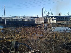
Ust-Kuiga
Urban-type settlement
|
||||||||||||||||||||||||||||||
|
||||||||||||||||||||||||||||||
|
||||||||||||||||||||||||||||||
Ust-Kuiga ( Russian Усть-Куйга́ ; Yakut Уус Куйга ) is an urban-type settlement in the Sakha Republic (Yakutia) in Russia with 979 inhabitants (as of October 14, 2010).
geography
The place is about 925 km as the crow flies north of the republic capital Yakutsk not far from the southwestern end of the Kjundjuljun Mountains on the right bank of the Jana , a little below the confluence of the right tributary Kuiga.
Ust-Kuiga belongs to the Ulus Ust-Janski and is located about 190 km west-northwest of its administrative center Deputatski . The settlement is the seat and only locality of the municipality (gorodskoje posselenije) Possjolok Ust-Kuiga.
history
The settlement was founded in 1951 at a pier on the Jana, as a transshipment base for the development of raw material deposits in the (today) Ulussen ( Rajons ) Ust-Janski, Werchojanski and Eweno-Bytantaiski . Since 1967 Ust-Kuiga has had the status of an urban-type settlement.
With the decline or the cessation of mining in the area, such as in Deputatski or the almost 100 km northwest of Kular , the importance of the settlement decreased significantly from the beginning of the 1990s, so that now over four fifths of the former residents left the place.
Population development
| year | Residents |
|---|---|
| 1970 | 1825 |
| 1979 | 2700 |
| 1989 | 5342 |
| 2002 | 1568 |
| 2010 | 979 |
Note: census data
traffic
Ust-Kuiga is the starting point of a nearly 250 km long paved road to the Ulus and mining center Deputatski. Ust-Kuiga itself can be reached by ship on the Jana during the ice-free period, otherwise it is connected to Topolinoje via a winter runway via Batagai and the Verkhoyansk Mountains , the end of a side road from the R504 Kolyma ( M56 ).
A few kilometers east of the settlement there is a small airport ( ICAO code UEBT ).
Web links
Individual evidence
- ↑ a b Itogi Vserossijskoj perepisi naselenija 2010 goda. Tom 1. Čislennostʹ i razmeščenie naselenija (Results of the All-Russian Census 2010. Volume 1. Number and distribution of the population). Tables 5 , pp. 12-209; 11 , pp. 312–979 (download from the website of the Federal Service for State Statistics of the Russian Federation)


