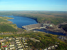
Chernyshevsky (Sacha)
Urban-type settlement
|
||||||||||||||||||||||||||||||||
|
||||||||||||||||||||||||||||||||
|
||||||||||||||||||||||||||||||||

Tschernyshevsky ( Russian Черныше́вский , Yakut Чернышевскай ) is an urban-type settlement in the Republic of Sakha (Yakutia) with 5025 inhabitants (as of October 14, 2010).
geography
The settlement is located on the southern edge of the Wiljuiplateau belonging to the Central Siberian mountainous region, about 900 kilometers west of the republic capital Yakutsk as the crow flies , on the right bank of the Lena tributary, Wiljui .
Chernyshevsky belongs to the Mirny Raion , from whose administrative center Mirny it is about 100 kilometers in a north-westerly direction. Chernyshevsky used to administer the Olguidach settlement 79 kilometers north on the road to Aichal and Udatschny , which in 1989 had around 500 inhabitants, but only 1 official inhabitant in 2001. Today Olguidach is deserted; the territory is part of the Evenk "National Nasleg" (Town) Sadyn with center in lower down on Vilyuy River village Sjuldjukar.
history
The settlement was established in 1959 in connection with the construction of the dam and hydropower plant of the Vilyui reservoir . In 1961 urban-type settlement status was given. The settlement was named after the writer, publicist and revolutionary Nikolai Chernyshevsky , who was in Siberian exile from 1864 to 1883 , including from 1871 in Wiljuisk , located downstream on the Wiljui .
The power plant was completed in 1976; thereafter the population decreased.
Population development
| year | Residents |
|---|---|
| 1970 | 9394 |
| 1979 | 6029 |
| 1989 | 8298 |
| 2002 | 5310 |
| 2010 | 5025 |
Note: census data
Economy and Infrastructure
The building company is the Wiljui hydropower plant (Wiljuiskaja GES) with an output of 680 megawatts , which primarily serves to supply the West Yakut diamond mining areas around Mirny and Aichal-Udatschny and is operated by Jakutskenergo . There is also a fish farm at the Wiljui reservoir, a forestry and geological exploration company.
The road running through the settlement runs from Lensk on the middle Lena via Mirny to the mining centers of Aichal and Udatschny, some 330 and 380 kilometers north of Chernyshevsky, respectively. The road is currently being expanded and is to be extended under the name Anabar to the Olenjok and Anabar rivers, which flow into the Arctic Ocean in the northwest of the Sakha Republic .
Individual evidence
- ↑ a b Itogi Vserossijskoj perepisi naselenija 2010 goda. Tom 1. Čislennostʹ i razmeščenie naselenija (Results of the All-Russian Census 2010. Volume 1. Number and distribution of the population). Tables 5 , pp. 12-209; 11 , pp. 312–979 (download from the website of the Federal Service for State Statistics of the Russian Federation)
- ↑ Tschernyshevsky ( Memento of the original from March 21, 2008 in the Internet Archive ) Info: The archive link was inserted automatically and has not yet been checked. Please check the original and archive link according to the instructions and then remove this notice. on the website of the Center for Socio-Economic and Political Monitoring of the Yakut State University (Russian)
Web links
- Official website of the settlement (Russian)

