
Nagorny (Sacha)
Urban-type settlement
|
||||||||||||||||||||||||||||||
|
||||||||||||||||||||||||||||||
|
||||||||||||||||||||||||||||||


Nagorny ( Russian Наго́рный ; Yakut Нагорнай ) is an urban-type settlement in the Republic of Sakha (Yakutia) in Russia with 68 inhabitants (as of October 14, 2010).
geography
The place is about 730 km as the crow flies south-southwest of the republic capital Yakutsk on the northern flank of the Stanovoi highlands , about 10 km from the main ridge of the mountains and thus the border with Amur Oblast . It is located on the right bank of the Aldan tributary, Timpton .
Nagorny belongs to Ulus Nerjungrinski and is located about 80 km south of its administrative center Nerjungri . The settlement is part of the municipality (gorodskoje posselenije) Possjolok Solotinka and is located about 30 km south of its center Solotinka .
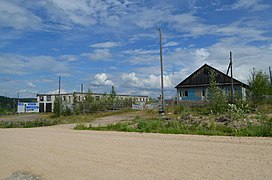
Building in Nagorny (2017)
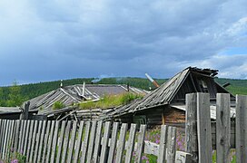
Destroyed buildings in Nagorny (2017)

Building in Nagorny (2017)

Bridge over the Timpton at Nagorny
.jpg)
.jpg)
.jpg)
.jpg)

history
The settlement was founded in the 1920s when the road from the Trans-Siberian Railway to the Aldan area and on to Yakutsk was built. The name refers to the high location in the Stanowoihochland, in Russian Stanowoje nagorje. The initial full name was Nagorny Priisk, where priisk is the common name in Russian for gold panning and the associated settlements. In 1927 the place became the administrative seat of Timptonski ulus, founded in 1926 (from 1930 Rajon ). The settlement remained the largest town in southern Yakutia until the 1940s. In 1941 the status of an urban-type settlement was given under its current name, but in 1943 the administrative seat of the Rajon was moved to the more centrally located Tschulman .
In the mid-1970s, the settlement experienced a temporary boom with the construction of the "Little BAM" Bamovskaya - Tynda - Neryungri, when temporary accommodation for several thousand construction workers was built at the train station about 5 km southeast of the original location. With the completion of the railway line and the lack of further economic development, most of the residents left the place in the 1980s to 1990s. The remaining residents live mainly in the "old" district. It is planned to give up the settlement entirely.
Population development
| year | Residents |
|---|---|
| 1939 | 2363 |
| 1959 | 662 |
| 1970 | 441 |
| 1979 | 3184 |
| 1989 | 913 |
| 2002 | 152 |
| 2010 | 68 |
Note: census data
traffic
The original settlement of Nagorny is located on the A360 Lena (formerly M56) highway , which connects Newer on the R297 Amur with Nizhny Bestjach not far from the Yakut capital of Yakutsk. At the place the road crosses the Timpton.
The Nagornaya-Yakutskaya station of the Amur-Yakut Railway Main Line (AJaM), which also runs from the Trans-Siberian Railway and the Baikal-Amur Main Line (BAM) to Nizhny Bestjach, is located about 5 km to the south-east at km 330 (from Skoworodino ) .
Web links
Individual evidence
- ↑ a b Itogi Vserossijskoj perepisi naselenija 2010 goda. Tom 1. Čislennostʹ i razmeščenie naselenija (Results of the All-Russian Census 2010. Volume 1. Number and distribution of the population). Tables 5 , pp. 12-209; 11 , pp. 312–979 (download from the website of the Federal Service for State Statistics of the Russian Federation)
- ↑ Information about the Rajon and its localities ( page no longer available , search in web archives ) Info: The link was automatically marked as defective. Please check the link according to the instructions and then remove this notice. on the official website (Russian)
| Cities |
Aldan R | Yakutsk S | Lensk R | Mirny R | Neryungri R | Nyurba R | Olyokminsk R | Pokrovsk R | Srednekolymsk R | Tommot | Udachny | Verkhoyansk | Wiljuisk R |
|
| Urban-type settlements |
Aichal | Allach-Jun | Almasny | Artyk | Batagai R | Belaja Gora R | Berkakit | Besymjanny | Chandyga R | Chani | Deputatski R | Jebariki-haya | Eldikan | Eat Chaija | Jugorjonok | Kyssyl-Syr | Lebediny | Leninsky | Mochsogolloch | Nagorny | Nizhnejansk | Nizhny Bestjach R | Nizhny Kuranach | Peledui | Sangar R | Schatai S | Serebryany Bor | Solnechny | Zolotinka | Swetly | Svyosdochka | Syrjanka R | Tiksi R | Torgo | Chernyshevsky | Chersky R | Tschokurdach R | Tschulman | Ust-Kuiga | Ust-Maja R | Ust-Nera R | Witim |
|
| Other Rajon centers |
Amga | Batagai-Alyta | Berdigestjach | Borogonzy | Chonuu | Namzy | Olenjok | Saskylach | Zhigansk | Suntar | Churaptscha | Verkhneviljuisk | Ytyk-Kjujol |