
Käferberg
| Käferberg and Waidberg | ||
|---|---|---|
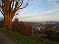
 View from Käferberg-Waidberg (from left to right) over Zürichberg , Adlisberg , Pfannenstiel , city center, Lake Zurich , Glarus Alps (background) and Albisgrat (March 2008) |
||
| height | 582 m above sea level M. | |
| location | City of Zurich, Canton of Zurich , Switzerland | |
| Dominance | 3.15 km → Zürichberg | |
| Notch height | 62 m ↓ on the Hönggerberg | |
| Coordinates | 681 648 / 251048 | |
|
||

The Käferberg ( 571 m above sea level ), together with the higher secondary summit Waidberg ( 582 m above sea level ) and the adjacent Hönggerberg ( 541 m above sea level ) to the west, form a range of hills in the city of Zurich and is one of its local mountains .
location
The Käferberg ( Chäferberg ) and the Waidberg are the highest elevations of an elongated range of hills north of the Limmat between Bucheggplatz and ETH-Hönggerberg , the so-called Science City . To the west of the high plateau ( 520 m above sea level ) of the ETH campus lies the Hönggerberg, which extends into the residential area of Rütihof , the highest point of which is in the so-called Bergholz .

The ridge runs northwest of the city center between the Limmattal and the Furttal , in the area of the urban quarters Wipkingen and Höngg ( District 10 ) and Affoltern ( District 11 ).
The highest points rise around 200 meters above the level of the Limmat near Letten , as part of a longer, mostly forested chain of hills between Wipkingen and Würenlos , which marks the watershed between the Limmat and Glatt .
The height of the hilltops increases from northwest to southeast: Hönggerberg ( 541 m above sea level ) and Käferberg with Waidberg (571 and 582 m above sea level ) as well as Zürichberg ( 676 m above sea level ) and Adlisberg ( 701 m above sea level ), the western foothills of the mountain range of the Pfannenstiel ( 853 m above sea level ).
To the east of the Käferberg, the 'green belt' is interrupted by settlement areas, where the city of Zurich extends over the lowest point of the range of hills, between Bucheggplatz ( 472 m above sea level ) and Milchbuck ( 476 m above sea level ), into the Furttal ( Affoltern), to Oerlikon / Zurich North and into the Glatttal ( Schwamendingen / Hirzenbach ).
history

The Käferberg and Käferholzstrasse are named after a piece of forest with a large collection of beetles, mainly cockchafer . The field name Waid is probably derived from the pasture area on the Käferberg. Höngg goes back to an Alemannic settlement called Hoinga or Hohinco, Hoenkain and villa Hoenka .
Together with 15 bulwarks , further entrenchments and letzines far outside the city at that time, the Käferberg was part of the so-called third city fortification in the 17th century .
A hospital was operated in the Zur Waid houses from 1907. In 1918 the old Waidgut became a municipal hospital , which was torn down in 1962/63 and replaced by what is now the Käferberg care center .
In the course of the incorporation , the community of Höngg ceded its forest area on the Käferberg to the city of Zurich in 1934, the remaining city forests were selectively passed into the city's ownership. Even today, there are larger, coherently agriculturally used areas on the Käferberg / Waidberg in the immediate vicinity of the “Science City” (ETH Hönggerberg).
Public transport
Tram and bus (VBZ)
The Zurich Public Transport (VBZ) make the residential and recreational area with public transportation easily accessible: Several bus routes open up the area around and on the Käferberg.
The bus line 80 crosses the Käferberg in north-south direction on the route from Triemli Hospital via Altstetten station to Affoltern to Oerlikon station . In addition to line 80, the ETH location is served from the east by bus line 69 and from the north-west ( Affoltern station ) by bus line 37. Two shuttle connections bring employees and students directly from Zurich main station and the main building to the campus. The buses are often fully used at peak times. After the planned electrification of lines 69 and 80, larger buses will be used.
The high parts of Höngg are accessed by line 38 (Waidspital – Meierhofplatz – Hönggerberg). The tram line 13 and the trolley bus line 46 operate the lower hill section Hongg to Frankental and Ruetihof.
Line 40 (Bucheggplatz-Friedhof Nordheim-Affoltern-Seebach) runs on the north side and trolleybus 32 and bus lines 61 and 62 go a little further from Käferberg.
Zurich S-Bahn
The Käferberglinie is the second connection between Oerlikon and the main train station. It was built in 1969 as a direct connection between Oerlikon and Altstetten for freight trains. In 1979 the double-track bridge to Zurich main station with the Hardbrücke stop was opened, and since 1990 the connection to the Zurich S-Bahn into the Limmat Valley has been ensured. The Käferberg line is used by the S5, S6, S7 and S16.

The Käferberg Tunnel is a 2'119 meter long, double-lane railway tunnel and part of the SBB- Käferberglinie, as the second connection between Glatttal and Limmattal, bypassing the Zurich main station (HB), which was already overloaded in the 1960s . In 1969, together with the tunnel, the single-lane Hardturm Viaduct I to the Altstetten station was opened in the south and served exclusively for freight traffic to today's Limmattal marshalling yard (RBL) . Since the opening (1982) of the double-lane Hardturm Viaduct II, passenger trains have also regularly used the Käferberg tunnel to Oerlikon station , and between 1982 and 1990 in particular the intercity traffic via the airport line .
When the Zurich S-Bahn began operating in May 1990, the Zurich Hardbrücke station on the Hardturm Viaduct II was greatly expanded and became the operational terminus of the Hirschengraben line , the heart of the S-Bahn. As a result, since 1990 all S-Bahn trains that serve Oerlikon and travel through the heart of the city have been forced to run through the Käferberg tunnel.
The single-tube, double-lane Weinberg tunnel has been the heart of the Altstetten – Zurich HB – Oerlikon (DML) cross-city link, the third railway line between Zurich's main train station and Oerlikon station , since 2013 . The tunnel serves to increase capacity and makes the change of direction in the terminus station on the Wiedikon – Oerlikon and Altstetten – Oerlikon connections superfluous.
Private transport
A well-developed road connection ( Emil Klöti-Strasse ) leads over the saddle at the “Science City” to the Affoltern district in the north , bypasses the ETH campus to the west and is separated in this area - the campus is separated by a bridge ( Einstein- Bridge ) and various ramps connected to the street, but also easily accessible with the mentioned bus lines 69 and 80 as well as a bus connection to the ETH center reserved for students. According to the master plan for Campus Hönggerberg 2040 published in May 2018, two new high-rise buildings are to be built, which will further exacerbate the problem of accessibility via bus connections.
Excursion destinations and sights
The south-facing slope of the Waidberg-Käferberg is a popular local recreation area in Zurich . Lean brine meadows thrive here , a rarity in the densely populated city, where knapweed , meadow sage and widow flowers bloom and sand lizards find a rare habitat. In particular, on the southern side have height allotments a long tradition, but also on the eastern and northern hillside.
Those interested in sport can be found on the Laufträff and on the Vitaparcours or go on hikes on the ridge to Baden .
Two restaurants, one with an impressive view of the Glarus Alps and across the entire city center and the other in the middle of the extensive forest area on the summit plateau, are very popular.
Above the Waid city hospital and the care center, a private deer breeding facility and a forest kindergarten are 'local attractions' not only known to residents. The Käferberg thermal bath , which is heated to 32 ° C and has a multi-purpose pool measuring 25 × 10 meters, a relaxation room, a gym, architecture suitable for the disabled and an outdoor sunbathing area with a view of the city of Zurich, Lake Zurich and the Glarus Alps, is well-known nationwide .

On the saddle between Hönggerberg and Käferberg is "Science City" , the ETH Hönggerberg campus of ETH Zurich . It houses the departments of chemistry , physics , materials science , architecture , civil engineering and biology . The ETH intends to build a residential area for students and researchers in the vicinity of the teaching and research facilities of Science City , as well as other shopping opportunities and cafés geared towards student interests in the center.
photos


Käferberg, view from the east

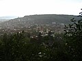
Käferberg-Waidberg, view from the south ( Triemlispital )

Waidberg, view from the west (near ETH Hönggerberg)

Käferberg care center, city center, Lake Zurich and Glarus Alps

Käferberg, view over the city center, Lake Zurich and the Glarus Alps
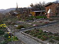
Allotment gardens on the southern slope
Waidberg, view of the city center


literature
- Building Construction Department of the City of Zurich, Office for Urban Development: Affoltern, Oerlikon, Schwamendingen, Seebach . Verlag Neue Zürcher Zeitung , Zurich 2003 (Baukultur in Zurich, Volume I), ISBN 3-03823-034-0
- Martin Bürlimann / Kurt Gammeter: Wipkingen - From Village to Quartier , Wibichinga Verlag, Zurich-Wipkingen 2006, ISBN 3-9523149-0-0
- Ursina Jakob / Daniel Kurz: Wipkingen Habitat History of a Zurich City Quarter 1893 - 1993
Web links
Individual evidence
- ↑ Rütihof or Birchrütihof refers to a medieval hamlet that was built in a cleared forest area of Hönggs; first mentioned in 1292. Riutun is the earlier name for Roden / Reuten ; see. also Matthias Dürst: The Rütihofstrasse. In: Gang dur Züri. Retrieved July 29, 2015 .
- ↑ The field name "Milchbuck" is derived from the terrain hill (Buck) near Irchelpark , which was known for its nutrient-rich meadow ( fat meadow ) and the high milk yield of the cows grazing there, cf. Matthias Dürst: The Milchbuckstrasse. In: Gang dur Züri. Retrieved July 29, 2015 .
- ^ A b Matthias Dürst: The Waidstrasse. In: Gang dur Züri. Retrieved July 29, 2015 .
- ↑ Matthias Dürst: The Hönggerstrasse. In: Gang dur Züri. Retrieved July 29, 2015 .
- ^ Georg Sibler: Höngg. In: Historical Lexicon of Switzerland .
- ^ Campus Hönggerberg. In: ETH Zurich. Retrieved April 2, 2019 .
- ↑ a b ETH students are annoyed by crowded buses. In: 20 minutes. October 4, 2018, accessed May 11, 2020 .
- ↑ ETH Hönggerberg Campus 2040. In: ethz.ch. Retrieved April 2, 2019 .
- ↑ Arrival at the ETH Zurich Hönggerberg event location. In: ethz.ch. Retrieved April 2, 2019 .
- ↑ Source: Green City Zurich website
- ↑ Science City project at ETH Zurich, Vision: City quarter for a culture of thought . The ETH Hönggerberg location is currently being expanded as part of the Science City project, with the aim of combining research and living on the university campus, which is also open to public concerns.