
Wielenbach
| coat of arms | Germany map | |
|---|---|---|

|
Coordinates: 47 ° 52 ' N , 11 ° 9' E |
|
| Basic data | ||
| State : | Bavaria | |
| Administrative region : | Upper Bavaria | |
| County : | Weilheim-Schongau | |
| Height : | 553 m above sea level NHN | |
| Area : | 33.02 km 2 | |
| Residents: | 3208 (Dec. 31, 2019) | |
| Population density : | 97 inhabitants per km 2 | |
| Postcodes : | 82407, 82362 | |
| Primaries : | 0881, 08158 | |
| License plate : | WM, SOG | |
| Community key : | 09 1 90 159 | |
| LOCODE : | De WB4 | |
| Community structure: | 11 parts of the community | |
| Address of the municipal administration: |
Peter-Kaufinger-Str. 10 82407 Wielenbach |
|
| Website : | ||
| Mayor : | Korbinian Steigenberger ( FW Bauerbach ) | |
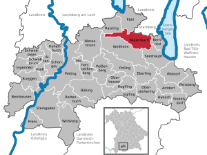
| Location of the municipality of Wielenbach in the Weilheim-Schongau district | ||
  |
||


Wielenbach is a municipality in the Weilheim-Schongau district in Upper Bavaria . It consists of the places Wielenbach, Wilzhofen, Bauerbach and Hardt.
geography
Wielenbach is located in the Oberland region .
The municipality has 11 officially named municipal parts (the type of settlement is given in brackets ):
|
There are the districts Haunshofen, Wielenbach, Hardt and the Josefsweiher .
history
Until the church is planted
The Roman Via Raetia laid out under Emperor Septimius Severus was decisive for the development of the place . The first dated mention was made on August 1, 1244, when Duke Otto II transferred the patronage of the parish church to the Wessobrunn monastery . Wielenbach belonged to the Munich Rent Office and the Weilheim district court of the Electorate of Bavaria . In the course of the administrative reforms in the Kingdom of Bavaria , today's municipality was created with the municipal edict of 1818 .
20th century
In 1912 a test facility of the “Royal Bavarian Biological Research Station for Fisheries” was founded in Wielenbach. After the Second World War , many expellees and repatriates settled in the community, and the population grew to 1160. This created the new Hardt settlement. This increase in inhabitants also ensured an economic upswing, which resulted in a further increase in the number of inhabitants.
The grave of the famous actress Brigitte Horney is located in the Wilzhofen part of the municipality .
Incorporations
On May 1, 1978, larger parts of the dissolved community of Haunshofen, which was created in 1818, were incorporated.
Population development
Between 1988 and 2018, the municipality grew from 2,603 to 3,216 by 613 inhabitants or 23.6%.
| year | 1840 | 1871 | 1900 | 1925 | 1939 | 1950 | 1970 | 1987 | 1991 | 1995 | 2000 | 2005 | 2010 | 2015 |
| Number of inhabitants | 659 | 742 | 875 | 1080 | 1013 | 1657 | 1949 | 2571 | 2811 | 2893 | 3009 | 3143 | 3162 | 3171 |
At the end of 2009, according to the municipality, 3269 people had their place of residence in Wielenbach and its districts (Wielenbach 1912, Hardt 269, Wilzhofen 463, Haunshofen 486, Bauerbach 139).
politics
Mayor and tax revenue
The mayor is Korbinian Steigenberger (free electorate Haunshofen-Bauerbach).
In 2014, the municipal tax income was € 2,608 thousand, of which € 667 thousand was trade tax income (net).
coat of arms
The official description of the coat of arms (blazon) reads: “In silver a blue wavy bar; A red key and a mutilated red branch crossed diagonally above, a black, silver-armored boar body below. "
Attractions
- Catholic Parish Church of St. Peter
Soil monuments
See: List of ground monuments in Wielenbach
Sports
The sports club SV Wielenbach e. V. plays with his two men's soccer teams in Class A 5
of the BFV and in B-Class 5. The sports club also offers tennis, running, cycling, gymnastics, curling, table tennis, volleyball and badminton.
Economy and Infrastructure
Economy including agriculture and forestry
In 2014 there were a total of 322 jobs subject to social security contributions in the municipality. Of the resident population, 1155 people were in employment subject to social security contributions. The number of out-commuters thus outweighed the number of in-commuters by 833.
In 2010 there were 58 farms in Wielenbach. 2289 hectares of the municipal area were used for agriculture, of which 1833 hectares were permanent green space.
traffic


Two single-track railway lines run through Wielenbach. In the west of the community the non-electrified Ammerseebahn runs from Mering via Geltendorf and Dießen to Weilheim , in the east the electrified Munich – Garmisch-Partenkirchen railway line . At the Ammersee Railway in 1983 abandoned was located to the west of the main town Wielenbach station Wielenbach . Existed south of the district Wilzhofen the station on the Munich-Garmisch-Partenkirchen railway Wilzhofen , which was shut down on June 2, 1984th Today there are no more passenger stations in Wielenbach, but the Wilzhofen station still serves as a depot with two tracks . The Wilzhofen station building is still preserved. To the southwest of the reception building, the former loading ramp and remnants of the loading track are still in place.
On February 1, 1866, the railway line from Munich via Tutzing and Weilheim to Unterpeißenberg was opened, where the Wilzhofen station was built. Until 1889, the route from Weilheim via Murnau to Garmisch-Partenkirchen was extended. The Ammerseebahn was opened on June 30, 1898 by the Royal Bavarian State Railways . The Wielenbach station was built on it. The station building, built in 1938, is a one-story brick building clad with wood. It contained a counter and service room as well as a goods hall. In addition to the continuous main track on the house platform , the station had a loading track branching off from the direction of Raisting to the east, on which mainly agricultural goods and small animals were loaded. Three barriers were operated from the station. Most recently, Wielenbach station was passed through by most trains without stopping or was only served as a stop on demand . In 1983 the station was shut down and only operated as a block post. The loading track was dismantled and the station building was sold in 1988. The building has been extensively rebuilt.
education
There are the following institutions (status: 2014):
- A day care center with 134 places and 107 registered children
- An elementary school with 159 students who are taught by nine teachers
Personalities
- Andrea Jochner-Weiß (* 1961), district administrator since May 1, 2014, lives in the Wilzhofen district
literature
- Siegfried Schwaiger: 1244 - 2019. Wielenbach was first mentioned 775 years ago. History of a ducal urban village . Wielenbach municipality, Wielenbach 2019
Web links
- Entry on Wielenbach's coat of arms in the database of the House of Bavarian History
- Wielenbach: Official statistics of the LfStat (PDF; 1.24 MB)
Individual evidence
- ↑ "Data 2" sheet, Statistical Report A1200C 202041 Population of the municipalities, districts and administrative districts 1st quarter 2020 (population based on the 2011 census) ( help ).
- ^ Community Wielenbach in the local database of the Bayerische Landesbibliothek Online . Bayerische Staatsbibliothek, accessed on September 4, 2019 .. There 12 official parts of the municipality are indicated, since a part of the municipality Diemendorf is listed, but it does not exist (anymore).
- ↑ a b Georg Paula , Stefanie Berg-Hobohm : District Weilheim-Schongau: Monuments in Bavaria. Volume 2, Lipp, Munich 2003, p. 652.
- ^ Federal Statistical Office (ed.): Historical municipality directory for the Federal Republic of Germany. Name, border and key number changes in municipalities, counties and administrative districts from May 27, 1970 to December 31, 1982 . W. Kohlhammer, Stuttgart / Mainz 1983, ISBN 3-17-003263-1 , p. 596 .
- ↑ Municipal statistics from Wielenbach (PDF) accessed on September 11, 2014
- ^ Andreas Janikowski: The Ammerseebahn. Traffic development in western Upper Bavaria . Transpress, Stuttgart 1996, ISBN 3-344-71033-8 , pp. 13-14 .
- ^ Andreas Janikowski: The Ammerseebahn. Traffic development in western Upper Bavaria . Transpress, Stuttgart 1996, ISBN 3-344-71033-8 , pp. 63-64 .
- ^ Description of the Wielenbach train station ( Memento from June 4, 2013 in the Internet Archive ) on Ammerseebahn.de

Cities: Penzberg | Schongau | Weilheim in Upper Bavaria
Markets: Peißenberg | Peiting
Other municipalities: Altenstadt (Upper Bavaria) | Antdorf | Bernbeuren | Bernried am Starnberger See | Böbing | Burggen | Eberfing | Eglfing | Habach | Hohenfurch | Hohenpeissenberg | Huglfing | Iffeldorf | Ingenried | Oberhausen (near Peißenberg) | Obersöchering | Pähl | Polling (near Weilheim) | Prem | Raisting | Rottenbuch | Schwabbruck | Schwabsoien | Seeshaupt | Sindelsdorf | Steingaden | Wessobrunn | Wielenbach | Wildsteig