
Zádveřice-Raková: Difference between revisions
Content deleted Content added
population |
population |
||
| (2 intermediate revisions by the same user not shown) | |||
| Line 1: | Line 1: | ||
{{Infobox settlement |
{{Infobox settlement |
||
| name = Zádveřice-Raková |
| name = Zádveřice-Raková |
||
| native_name = |
|||
| other_name = |
| other_name = |
||
| settlement_type = [[Obec|Municipality]] |
| settlement_type = [[Obec|Municipality]] |
||
<!-- images |
<!-- images --> |
||
| image_skyline = Zádveřice-Raková, Zádveřice, church.jpg |
| image_skyline = Zádveřice-Raková, Zádveřice, church.jpg |
||
| image_caption = Evangelical church in Zádvěřice |
| image_caption = Evangelical church in Zádvěřice |
||
| image_flag = Flag of Zádveřice-Raková.svg |
| image_flag = Flag of Zádveřice-Raková.svg |
||
| image_shield = CoA of Zádveřice-Raková.svg |
| image_shield = CoA of Zádveřice-Raková.svg |
||
| etymology = |
|||
<!-- location --> |
<!-- location --> |
||
| subdivision_type = Country |
| subdivision_type = Country |
||
| Line 38: | Line 36: | ||
| elevation_m = 264 |
| elevation_m = 264 |
||
<!-- population --> |
<!-- population --> |
||
| population_as_of = |
| population_as_of = 2023-01-01 |
||
| population_footnotes = <ref>{{cite web |title=Population of Municipalities – 1 January |
| population_footnotes = <ref>{{cite web |title=Population of Municipalities – 1 January 2023|url=https://www.czso.cz/csu/czso/population-of-municipalities-1-january-2023|publisher=[[Czech Statistical Office]]|date=2023-05-23}}</ref> |
||
| population_total = |
| population_total = 1517 |
||
| population_density_km2 = auto |
| population_density_km2 = auto |
||
<!-- time zone(s) --> |
<!-- time zone(s) --> |
||
| Line 62: | Line 60: | ||
==Administrative parts== |
==Administrative parts== |
||
Zádveřice-Raková is made up of villages of Zádveřice and Raková. |
Zádveřice-Raková is made up of villages of Zádveřice and Raková. |
||
==History== |
|||
The first written mention of Zádveřice is from 1261 and of Raková from 1549.<ref>{{cite web |title=Historie obce|url=https://www.zadverice-rakova.cz/historie/ds-1042/p1=1864|publisher=Obec Zádveřice-Raková|language=cs|access-date=2022-01-01}}</ref> Zádveřice and Raková merged in 1960.<ref>{{cite web |title=O obci|url=https://www.zadverice-rakova.cz/obec/ds-50/p1=51|publisher=Obec Zádveřice-Raková|language=cs|access-date=2022-01-01}}</ref> |
|||
==Gallery== |
==Gallery== |
||
| Line 74: | Line 75: | ||
{{reflist}} |
{{reflist}} |
||
{{ |
{{commons category|Zádveřice-Raková}} |
||
{{Zlín District}} |
{{Zlín District}} |
||
Latest revision as of 10:39, 29 May 2023
Zádveřice-Raková | |
|---|---|
 Evangelical church in Zádvěřice | |
 Flag  Coat of arms | |
 Zádveřice-Raková Location in the Czech Republic | |
| Coordinates: 49°12′58″N 17°48′13″E / 49.21611°N 17.80361°E | |
| Country | |
| Region | Zlín |
| District | Zlín |
| First mentioned | 1261 |
| Area | |
| • Total | 17.97 km2 (6.94 sq mi) |
| Elevation | 264 m (866 ft) |
| Population (2023-01-01)[1] | |
| • Total | 1,517 |
| • Density | 84/km2 (220/sq mi) |
| Time zone | UTC+1 (CET) |
| • Summer (DST) | UTC+2 (CEST) |
| Postal code | 763 12 |
| Website | www |
Zádveřice-Raková is a municipality in Zlín District in the Zlín Region of the Czech Republic. It has about 1,500 inhabitants.
Zádveřice-Raková lies approximately 11 kilometres (7 mi) east of Zlín and 263 km (163 mi) east of Prague.
Administrative parts[edit]
Zádveřice-Raková is made up of villages of Zádveřice and Raková.
History[edit]
The first written mention of Zádveřice is from 1261 and of Raková from 1549.[2] Zádveřice and Raková merged in 1960.[3]
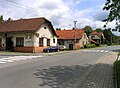
Gallery[edit]
-
 Municipal office and the fire brigade
 -
 Restaurant
 -
 Raková
 -
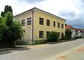 Old school building


References[edit]
- ^ "Population of Municipalities – 1 January 2023". Czech Statistical Office. 2023-05-23.
- ^ "Historie obce" (in Czech). Obec Zádveřice-Raková. Retrieved 2022-01-01.
- ^ "O obci" (in Czech). Obec Zádveřice-Raková. Retrieved 2022-01-01.
Wikimedia Commons has media related to Zádveřice-Raková.
| Authority control databases: National |
|---|
This Zlín Region location article is a stub. You can help Wikipedia by expanding it. |