Hamburg-Altona-Altstadt
|
Altona-Altstadt district of Hamburg |
|
|---|---|
| Coordinates | 53 ° 32 '56 " N , 9 ° 56' 52" E |
| surface | 2.8 km² |
| Residents | 29,169 (Dec. 31, 2019) |
| Population density | 10,418 inhabitants / km² |
| prefix | 040 |
| district | Altona district |
| Transport links | |
| Federal road |
|
| S-Bahn Hamburg |
|
| Source: Statistical Office for Hamburg and Schleswig-Holstein | |
Altona-Altstadt is a district of Hamburg in the Altona district . The district boundaries encompass the core area of the Holstein city of Altona (Elbe), which was independent until 1938 .
geography
The district borders in the west and northwest with Kaistraße, Museumstraße, Max-Brauer-Allee and Holstenstraße on Ottensen and Altona-Nord , in the north with Stresemannstraße on the Sternschanze district , newly formed in 2006 , in the east with Bernstorffstraße, Kleine Freiheit, Holstenstraße, Pepermölenbek , Drum Street and Antonist Street on St. Pauli and in the south on the Elbe .
Until Altona was incorporated into Hamburg in 1938, the border ran further east: from the shoulder blade , along the Grüner Jäger, east of Bleicherstraße and Grosse Freiheit , then between Finkenstraße and Herrenweide to Bachstraße (today Pepermölenbek) and with this to the Elbe. It was then moved to the west in favor of St. Pauli to the Holstenstrasse – Kleine Freiheit – Bernstorffstrasse line; In the south, a small area between Hein-Köllisch-Platz and Pinnasberg Altona was allocated for this purpose. As a result of this demarcation, the Große Freiheit, which is only typical for Altona (and especially not for the Hamburg area), and the Nobistor with the Altona city coat of arms and the monogram of King Christian VIII of Denmark has been in Hamburg-St. Pauli, while the St. Pauli Church, which gives this district its name, is now also in Altona, as is St. Pauli Fischmarkt street .
history
Altona was founded around 1535 as a fishing settlement in the county of Holstein-Pinneberg . According to legend, the nucleus and the reason for the name should have been a red beer pub owned by the fisherman Joachim von Lohe , around which craftsmen and fishermen settled - but in the opinion of the Hamburg council all too close ("too close") to the city limits. The geest slope between the later Nobistor and the Altona fish market in the area of today's Pepermölenbek street is assumed to be the exact location .
With the County of Holstein-Pinneberg, Altona became part of the Duchy of Holstein in 1647 and was given over to the present sovereign King Friedrich III. elevated to a town by Denmark on August 23, 1664. Gradually it grew to become the second largest city in the entire Danish state .

Before that, the city had to suffer cremation by Swedish troops in January 1713 during the Great Northern War . Starting in the east, house by house was set on fire by the Swedish soldiers of General Stenbock . This total destruction explains why, apart from the Palmaille roads, almost nothing is reminiscent of the Altona before the Swedish fire. However, Altona was built up and expanded again very quickly afterwards (see also Christian Detlev von Reventlow ).
Northern Europe's first free port was established in Altona . It had its heyday under the mayor Carl Heinrich Behn († 1853), during whose term of office the Schleswig-Holstein War (1848-1851) also fell. After the German-Danish War (1864) and the Prussian-Austrian War , Schleswig-Holstein as a whole became the Prussian province of Schleswig-Holstein in 1867 .
The old town today
In July 1943, Royal Air Force bombers destroyed large parts of the old town and, in particular, transformed the extremely densely populated border area to St. Pauli between Nobistor and Allee, Holstenstraße (in some areas with up to 800 people / ha) with workers, beneficiaries and socially declassed people and Grosse Elbstraße into a large field of ruins (→ Operation Gomorrah ). The quarter, which the authorities in the Weimar period called the “Abruzzo district” because of its politically and socially barely controllable population mix (workers, beneficiaries and socially declassified), became after the end of the war just like Altona's “more respectable” core around the old town hall and the Coin market not rebuilt.
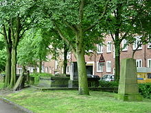
Only the main church of St. Trinity was restored and could be preserved - like the Jewish cemetery opposite on Königstraße. Further to the west, in the direction of the town hall and the train station, the Palmaille streets in particular, with their upper-class buildings from the early 19th century, remained largely intact; next to the entrance to the Königstrasse S-Bahn station (corner of Behnstrasse and Struenseestrasse), the remains of the Heilig-Geist-Kirchhof have been integrated into a green area there.
In the destroyed part of the old town, due to the Neu-Altona planning, multi-storey apartment buildings were built in a relaxed construction, interspersed with individual high-rise buildings, north of the fish market, on the Hexenberg, again in high density. This "New Altona" stretches to the northwest with a green corridor along Holstenstrasse. This is to interconnected parks, a portion was in the 1980s by Walter Möller , one of the Bloody Sunday victims , Walter-Möller-Park called. Another part has been dedicated to the communist Emil Wendt since 2015 . Only between Thedestrasse and Max-Brauer-Allee, i.e. in the area of Behn's urban expansion, were the old buildings still closed after 1945 , and active residents of the district succeeded in doing so from the beginning of the 1980s, whose preservation was still favored at the time Enforce concept of area rehabilitation .
The narrow streets with the repaired houses still show the same urban layout today as they did during the Weimar Republic - but without the problems at the time that the population density in the then densely populated German city brought with it: the inner block areas were mostly gutted, the apartments adapted to today's standards and, where possible, also added some green to the street space. On the other hand, this area is now also suffering from the effects of motorized individual traffic , despite traffic calming measures .
In this quarter north of the Große Bergstraße you can still find a lot of Altona city history:
- One of the oldest preserved buildings from the time of Behn's city expansion (built around 1860), which was saved from demolition around 1990, is located at Billrothstrasse 55 .
- The former public kitchen of the dining establishment for the poor and poor (1880) is located in Billrothstraße 77 , next to it is the Altona City Mission (1889).
- Between Chemnitzstrasse and Max-Brauer-Allee lies the August-Lütgens-Park, also named after a blood Sunday victim, with its old trees: this is the site of the former municipal hospital (until the 1970s), the main building of which (1869) was built by Heinrich, the city architect at the time Oskar Winkler comes from and today houses the college for social education. The rear pavilion buildings (houses 2, 3 and 7, built from 1880) are used by cultural associations, a daycare center and a district center. Next to the main building is the former sister house (Max-Brauer-Allee 136) planned by Gustav Oelsner in 1927 in the style of the New Building , behind it - in the park - the "Jenckelhaus" from 1912, in which condominiums have been located since the 1980s and how almost the entire system could be saved from the intended demolition.
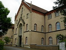
- At the northern end of Thedestrasse there is a listed brick ensemble , consisting of a semicircular indoor swimming pool (the Thedebad , built in 1882, is now used as a studio and for office purposes) and the school opposite, the middle section of which (1867) is the oldest preserved public school building in the Hamburg area is; the side wings were added in 1892.
Historical and current street names
Anyone who deals with the history of Altona repeatedly comes across street names that can no longer be found in the city map; This is mainly due to the fact that the streets were either not laid out again after 1945 or were renamed around 1950 (as a late consequence of the Altona incorporation), sometimes even later. Therefore, the old (left) and new (right) street names of the old town are compared here:
- Adlerstrasse = Scheplerstrasse
- Adolphstraße = Bernstorffstraße (northern part)
- Allee = Max-Brauer-Allee
- Bahnhofstraße = Max-Brauer-Allee (southern part)
- Altonaer Hochstraße = Breite Straße (no longer available connection to the Hamburger Hochstraße near the Hexenberg)
- At the main station = Altonaer Bahnhofsplatz, since 1984 Paul-Nevermann-Platz
- Amselstraße = At the Schiller Opera
- Bachstrasse = Pepermölenbek
- Bäckerstraße = Hoheschulstraße
- Bebelallee = Hohenzollernring
- Blumenstrasse = Billrothstrasse
- Brahmsstrasse = Griegstrasse
- Brunnenstrasse = Bernstorffstrasse (southern part)
- Bürgerstrasse = Thedestrasse
- Carlstraße = since 1992 Karl-Wolff-Straße (after a blood Sunday sacrifice)
- Carolinenstrasse = Olbersweg
- Catharinen- / Katharinenstraße = Elmenhorst- / Schleestraße
- Feldstrasse = Eschelsweg
- Friedensstrasse = Lippmannstrasse
- Friedrichsbader Straße = Holstenstraße (southernmost part)
- Fritz-Reuter-Straße = Goetheallee
- Georgstrasse = Mumsenstrasse
- Große Brauerstraße = de-Voss-Straße
- Große Gärtnerstraße = Thadenstraße
- Große Mühlenstraße = Amundsenstraße
- Große Rosenstraße = Paul-Roosen-Straße (today St. Pauli)
- Große Westerstraße = Jessenstraße
- Grüner Weg = Alsenstraße (southernmost part at Holstenbahnhof)
- Grüne Strasse = Kirchenstrasse
- Gustav-Adolf-Platz = Steinheimplatz
- Gustavstrasse = Gilbertstrasse
- Hafenstrasse = Carsten-Rehder-Strasse
- Hamburger Straße = Max-Brauer-Allee (northern part)
- Herderstrasse = Haubachstrasse
- Humboldtstrasse = Willebrandstrasse
- Kaiserstraße = Museum Street
- Kaiserplatz = Republic Square (Hamburg)
- Karl-Marx-Straße = Stresemannstraße (western part)
- Kleine Elbstraße = Pinnasberg (western part)
- Kleine Fischerstrasse = Buttstrasse
- Kleine Gärtnerstrasse = Stresemannstrasse (eastern part)
- Kleine Mühlenstraße = Struenseestraße
- Kleine Westerstraße = Lawaetzweg
- Way of the Cross = Stresemannstraße (at today's Kaltenkirchener Platz)
- Lessingstrasse = Julius-Leber-Strasse
- Lohmühlenstraße = Esmarchstraße
- Marktstrasse = Ehrenbergstrasse
- Mathildenstrasse = Schillerstrasse
- Mühlendamm = Govertsweg
- Nachtigallstraße = Lerchenstraße (north of Stresemannstraße)
- Norderstraße = Virchowstraße (southern part)
- Palmaillenstrasse = Behnstrasse
- Parallel street = Eifflerstraße
- Paulstrasse = Otzenstrasse
- Poststrasse = Altonaer Poststrasse
- Reventlowplatz = Paulsenplatz
- Röperstraße = Sägemühlenstraße
- Schauenburger Strasse = Schomburgstrasse
- Schillerstraße = Lamp'lweg (only north end between Max-Brauer-Allee and Groß Bergstraße)
- Sonninstraße = Biernatzkistraße
- Steinstraße = Hospitalstraße (south / middle section)
- Stiftstraße = Dohrnweg, Mistralstraße
- Teichstraße = Funkstraße (was repealed in 1970 in favor of the new development on the Gr. Bergstraße / south side)
- Treskowallee = Bleickenallee
- Turnstrasse = Schmarjestrasse
- Weidenstrasse = Virchowstrasse (central / northern part); its northern continuation, the then "Carlstrasse" (see map from 1880) has been called Karl-Wolff-Strasse since 1992 (after a blood Sunday sacrifice)
- Wielandstrasse = Suttnerstrasse
- Wilhelmstrasse = Chemnitzstrasse
No longer available (mainly in the south or south-east part of the old town)
- Altona town hall market
- Annenstrasse
- Bläserstrasse
- Boehmkenstrasse
- Christianstrasse
- Dennerstrasse
- Friedrichstrasse
- Big and Small Johannisstraße
- Great and Little Papagoy Road
- Big and Small Schmiedestrasse
- Great Marienstrasse
- Great Rosenstrasse
- reason
- Herklosgang
- Kibbelstrasse
- Kleine Brauerstrasse
- Konradstrasse
- Long street
- Lohestrasse
- Marienstrasse
- Coin market
- Palmaillenhain
- Quaker Mountain
- Raboisen
- Reichenstrasse
- Rolandstrasse
- Slaughterhouses
- Narrow path
- Seestermannstrasse
- Van-der-Smissens-Allee (not identical to Van-der-Smissen-Straße, which was only named in 1991)
- Wilhelminenstrasse
- various passages and corridors (i.e. built-up backyard access) such as Ehlbeck's terrace, Rodenhof, Pfeiffersgang
Names that only existed during the Nazi dictatorship (in brackets: name before 1933 or after 1945 )
- Adolf-Hitler-Platz, from 1938 Reichsplatz (Republic Square , Republic Square )
- Christian-Andersen-Strasse (Gustavstrasse, Gilbertstrasse )
- Fürst-Ernst-Strasse (Schauenburger Strasse, Schomburgstrasse )
- General-Litzmann-Strasse (Kleine Gärtnerstrasse, Stresemannstrasse east of Holstenstrasse)
- Grimmelshausen-Weg (Wielandstrasse, Suttnerstrasse )
- Harpunierstrasse (Friedensstrasse, Lippmannstrasse )
- Hermann Schnell Platz (Paulsenplatz, Paulsenplatz )
- Hinrich-Lohse-Strasse (Königstrasse, Königstrasse )
- Matthäus-Chemnitz-Strasse (Wilhelmstrasse, Chemnitzstrasse )
- Nopitsch-Weg (Norderstrasse, Virchowstrasse )
- Pettenkofer-Strasse (Steinstrasse, Hospitalstrasse )
- Schlageterstrasse (Karl-Marx-Strasse, Stresemannstrasse )
The Große Bergstrasse business center
The Große Bergstraße stretched from the Altona train station to Kleine Freiheit / Reichenstraße (today Holstenstraße / Nobistor ). In the 1960s it was shortened by half with the creation of the Simon-von-Utrecht-Strasse / Louise-Schroeder-Strasse / Jessenstrasse / Ehrenbergstrasse axis and the renaming of its eastern end to Nobistor . The construction of the Neue Große Bergstraße south of the Große Bergstraße between Altonaer Poststraße and Bahnhofsplatz as the first pedestrian shopping street was followed around 1970 - after the demolition of the entire south side of the Große Bergstraße between Virchow- and Altonaer Poststraße - the new construction of the Frappant shopping center and the Forum Altona .
Since the 1990s, there have been some long-term vacancies in shops in the Altona-Passage and in the former Frappant building on Goetheplatz, as well as the closure of “customer magnets” (such as Karstadt ). As of 2009, the area is a redevelopment area; IKEA has been interested in the Frappant complex, in which artists have settled since 2003, since the beginning of 2009 and opened its first inner-city full-range furniture store here in June 2014. In this context, two petitions for and against its settlement were initiated; the population voted for the construction with a three-quarters majority.
statistics
- Minor quota: 15.3% [Hamburg average: 16.3% (2017)].
- Elderly rate: 12.9% [Hamburg average: 18.2% (2017)].
- Proportion of foreigners: 19.6% [Hamburg average: 17.1% (2017)].
- Unemployment rate: 7.1% [Hamburg average: 5.2% (2017)].
The average income per taxpayer in Altona-Altstadt is EUR 30,833 annually (2013), the Hamburg average is EUR 39,054.
politics
Altona-Altstadt belongs to the constituency of Altona for citizenship elections . The 2015 state election led to the following result:
- SPD 35.2% (−11.4)
- The left 23.8% (+ 7.3)
- Greens 22.3% (+4.6)
- CDU 5.0% (−2.1)
- FDP 3.2% (+0.8)
- AfD 3.0% (+3.0)
- Other 7.5% (−2.2)
Buildings and sights
- St. Trinitatis , the former main baroque church in Altona, planned by Cay Dose in 1742/43
- New Altona town hall , the south wing from 1844 is the former Altona train station of the Altona-Kieler Eisenbahn-Gesellschaft .
- The classicist St. Pauli Church on the Pinnasberg, built in 1819 , used to belong to the Hamburg district of St. Pauli and gave it its name.
- Platz der Republik , a representative green space between the Altona town hall and the Altona train station
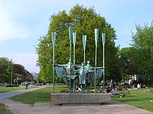
- Chair man fountain in the square of the Republic, provides two fighting each other centaurs , which fall as a symbol of economically competitive cities Altona / Elbe and Hamburg are interpreted
- Schellfisch tunnel , now closed, formerly the longest railway tunnel in Northern Germany from the Altona train station under the Elbe slope down to the Altona port railway near Neumühlen
- For Sunday fish market is, to a large extent by tourists but also by locals after a night on the neighborhood visited
- The Köhlbrandt staircase, which was inaugurated in 1887 and is now a listed building, is located near Grosse Elbstrasse; In the immediate vicinity, there are also two typical Altona restaurants that used to be visited mainly by dock workers, seafarers and workers in the fishing industry: the Haifischbar , which gave its name to a television show of the same name from the 1960s, and Zum Hellfischposten , which has hosted the TV program since 2007 Inas night is recorded
- Altona balcony on the Elbe slope, a vantage point with a wide view over the port of Hamburg
- Beginning of the Elbe bank hiking trail along the water towards Övelgönne and Blankenese to Wedel
- New buildings on the banks of the Elbe, e.g. B. Dockland office building and Hamburg Cruise Center Altona
- Altona Jewish Cemetery , an important Jewish burial ground on Königstrasse
School, education and research
After the Bruno Tesch Comprehensive School in Billrothstrasse was closed in 2004, there are still six schools in Altona-Altstadt: the Thadenstrasse elementary school, the Louise Schröder School (former Chemnitzstrasse elementary school) in Thedestrasse on a sub-area of the former Bruno-Tesch -Gesamtschule, the Struensee-Gymnasium, the special school Carsten-Rehder-Straße, the Catholic School Altona and the all-day school Bernstorffstraße. In addition there is the technical school for social pedagogy II. The Gymnasium Allee is already in Altona-Nord .
A public book hall is located at Norderreihe 5.
The Federal Research Center for Fisheries is located on the Palmaille, and the Institute for Hydrobiology and Fisheries Science belonging to the University of Hamburg is just a stone's throw away in Olbersweg . Both research institutions cooperate with each other.
See also
- List of streets, squares and bridges in Hamburg-Altona-Altstadt
- List of cultural monuments in Hamburg-Altona-Altstadt
- List of stumbling blocks in Hamburg-Altona-Altstadt
Web links
- Website of the Altonaer Stadtarchiv eV
- Information on the Altona-Altstadt development quarter
- Website of the city of Hamburg
Sources and Notes
- ↑ AP McElligott: The “Abruzzo Quarter”. Workers in Altona 1918–1932 . In: Arno Herzig et al. (Ed.): Workers in Hamburg. Lower layers. Workers and the labor movement since the late 18th century. Verlag Erbildung und Wissenschaft, Hamburg 1983, pp. 493–507.
- ↑ taz article from September 15, 2009 on both requests
- ↑ Quota of minors in the Hamburg districts in 2017
- ↑ Proportion of 65-year-olds and older in the Hamburg districts in 2017
- ↑ Proportion of foreigners in the Hamburg districts in 2017
- ↑ Unemployment rate in the Hamburg districts in 2017
- ↑ Statistical Office for Hamburg and Schleswig-Holstein (ed.): Hamburg District Profile 2016 (= NORD.regional . Volume 19 ). 2018, ISSN 1863-9518 ( Online PDF 6.6 MB [accessed February 12, 2018]).
- ↑ http://www.wahlen-hamburg.de/wahlen.php?site=left/gebiete&wahltyp=3#index.php?site=right/result&wahl=973&beispiel=0&gebiet=4&idx=0&typ=4&stimme=2&hoch=0&partei=&untertyp = 23 & flip = 1 & seat = 0 & seat high = 0 & mode = list


