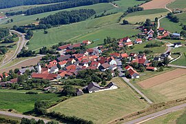
Drove
|
Drove
City of Neunburg vorm Wald
Coordinates: 49 ° 20 ′ 37 ″ N , 12 ° 16 ′ 46 ″ E
|
||
|---|---|---|
| Height : | 510 m above sea level NHN | |
| Residents : | 141 (Dec 31, 1990) | |
| Incorporation : | January 1, 1972 | |
| Postal code : | 92431 | |
| Area code : | 09439 | |
|
Location of Fuhrn in Bavaria |
||
Fuhrn is a district of the city of Neunburg vorm Wald in the Schwandorf district in Bavaria .
geography
Fuhrn is about nine kilometers west of Neunburg vorm Wald on the state road 2151 , which connects Neunburg vorm Wald with the A 93 in Schwarzenfeld .
history
Fuhrn is one of the oldest localities in the district. Your name does not allow any German interpretation. An origin from the South Slavic is possible, as a place that is very exposed to the wind, Sturmplatz. Fuhrn was mentioned in writing as early as 1031 under the name Furdona. As Vogt of the Sankt Emmeram monastery in Regensburg , the Duke of Bavaria was in charge of the church in Fuhrn. The St. Emmeram monastery owned 10 acres in Fuhrn in 1100 with an income of 10 Schilling Pfennigs. This area is still called monastery fields in Fuhrn today. Fuhrn belonged to the ducal Auerbach in 1283 . In 1433 it was registered as a parish in the Regensburg diocesan register. Fuhrn was a parish earlier than Kemnath ; it was, so to speak, the mother parish of Kemnath. In 1675 the parishes of Kemnath and Fuhrn were merged and Fuhrn lost its independence.
On March 3, 1913, Fuhrn was the branch of the parish Kemnath bei Fuhrn, consisted of 26 houses and had 152 inhabitants. On December 31, 1990 Fuhrn had 141 inhabitants and was the branch of the parish of Kemnath near Fuhrn.
Culture and sights
Church of St. Peter and Paul
Fuhrn has a Romanesque church, the current structure of which dates from the 13th or 14th century. The interior is designed in the Baroque and Rococo styles .
In the cemetery there is a medieval stone cross that originally stood at the junction to Hofenstetten.
See also: List of architectural monuments in Neunburg vorm Wald, section Fuhrn
Hirschberg observation tower
On a hilltop north of Fuhrn is the Ramberg castle stable , the remains of a medieval moat and rampart.
At 571 m above sea level NHN high Hirschberg south of Fuhrn has stood since 1973 on a 556 m above sea level north-west of the summit . NHN high mountain spur is a 26.5 m high observation tower made of wood.
Daughters and sons of the place
- Peter Wilhelm (* 1946), German lawyer and former head of the State Office for Finance , holder of the Federal Cross of Merit on ribbon
literature
- Anton Neckermann: Neunburg district in front of the forest. Publishing house for authorities and economy R. Alfred Hoeppner Munich-Assling, 1968
Web links
- List of monuments for Neunburg vorm Wald (PDF) at the Bavarian State Office for Monument Preservation
Individual evidence
- ↑ Fritsch hiking map of the Upper Palatinate Forest, scale 1: 100,000
- ^ Anton Neckermann: Neunburg district in front of the forest. Publishing house for authorities and economy R. Alfred Hoeppner Munich-Assling, 1968
- ^ Anton Neckermann: Neunburg district in front of the forest. Publishing house for authorities and economy R. Alfred Hoeppner Munich-Assling, 1968
- ^ Antonius von Henle (Ed.): Register of the Diocese of Regensburg. Verlag der Kanzlei des Bischöflichen Ordinariates Regensburg, 1916, p. 499
- ↑ Manfred Müller (Ed.): Register of the diocese of Regensburg. Verlag des Bischöflichen Ordinariats Regensburg, 1997, p. 293
- ↑ List of monuments for Neunburg vorm Wald (PDF) at the Bavarian State Office for Monument Preservation
- ↑ Map services of the Federal Agency for Nature Conservation ( information )
- ↑ Peter Wilhelm receives the Federal Cross of Merit. In: Mittelbayerische.de. January 7, 2015, accessed October 2, 2019 .


