Beja (Portugal)
| Be yes | ||||||
|---|---|---|---|---|---|---|
|
||||||
| Basic data | ||||||
| Region : | Alentejo | |||||
| Sub-region : | Baixo Alentejo | |||||
| District : | Be yes | |||||
| Concelho : | Be yes | |||||
| Coordinates : | 38 ° 1 ′ N , 7 ° 52 ′ W | |||||
| Residents: | 35,854 (as of June 30, 2011) | |||||
| Surface: | 1 146.43 km² (as of January 1, 2010) | |||||
| Population density : | 31 inhabitants per km² | |||||
| Beja district | ||||||
|
||||||
| Residents: | 35,854 (as of June 30, 2011) | |||||
| Surface: | 1 146.43 km² (as of January 1, 2010) | |||||
| Population density : | 31 inhabitants per km² | |||||
| Number of municipalities : | 12 | |||||
| administration | ||||||
| Administration address: | Câmara Municipal de Beja Praça da Republica 7800-427 Beja |
|||||
| President of the Câmara Municipal: | Jorge Pulido Valente ( PS ) | |||||
| Website: | www.cm-beja.pt | |||||
Beja is a city in the Alentejo region of southern Portugal . The urban area includes the four parishes of Salvador , Santa Maria da Feira , Santiago Maior and São João Baptista , with which Beja has a population of around 40,000. There is no separate community ( freguesia ) with the name Beja.
The city's roots go back to Celtiberian times. The oldest relics date from Roman times, one of the two churches of the early Middle Ages in Portugal comes from Visigoth times. At the beginning of the 8th century the city became Muslim and remained so - with an interruption from 1162 to 1167 - until 1228. It produced important poets and humanists in both Muslim and Christian times.
history
Beja was probably founded in the 5th century BC. Founded by the Celts , but the first mentions were made in the 2nd century BC. By Polybius and Ptolemaeus .
The Romans named the city Pax Julia , built a road and the city received one of the four Lusitanian law firms created under Augustus .
In the 5th century Alans , Suebi and Vandals appeared on the territory of Portugal, the region around Beja was first occupied by Alans, then by Suebi. Alans and Vandals left the Iberian Peninsula as early as 428 to conquer North Africa. They were followed around 430 by the Suebi who conquered Beja around 440. The Visigoths occupied Seville in 473 and should soon have conquered Beja too; the Suebi withdrew to the northwest of the Iberian Peninsula. Beja was the first seat of a diocese and was named Paca .
The Arabs and Berbers, known as Moors , under the leadership of the Umayyads , who ruled the Arab Empire between 661 and 750 and conquered the region at the beginning of the 8th century, surrounded the city with a new wall. Muslim rule continued under changing masters until 1162. After the Umayyads, the Abadids of Seville played a prominent role. During this time the city was named Beja. It became the birthplace of Al-Mutamid , who not only ruled the city, but also became one of the most important poets. In 756 one of the Umayyads fled from the Abbasids , who ruled the Arab world empire from 750 and made Damascus their capital, to the west and founded an empire on the Iberian Peninsula . By 760, Abd ar-Rahman I managed to conquer the Muslim area there. The dynasty he founded ruled until 929, first as emirs , then as caliphs .
After the fall of the Caliphate of Cordoba in 1031, numerous partial rulers, the Taifa kingdoms, emerged . Beja was initially under the Aftasids until it fell to the Kingdom of Seville. In the years 1162 to 1167, Christian units, among whose leaders Geraldo sem Pavor stood out , succeeded for the first time in pushing through a major offensive, and one of the leaders, Fernando Gonçalves from Santarém , briefly captured Beja in 1162.
With the conquest by the Almohad Berber, Beja became part of a large empire with contacts to North Africa. This period was dominated by rulers such as Ibn Al-Mundhir, Ibn Qasi and the last Moorish king, whom the Portuguese called "Aben Afan". Ibn Wazir from Silves ruled over Beja and Évora for a few years until 1157 .
From 1228 Paio Peres Correia began the final conquest of the Algarve on behalf of the Portuguese king , and Beja fell in 1235. In the Christian era, too, the city produced important poets such as Diogo de Gouveia (1471–1557), the teacher of Francisco de Xavier and counselor to King Joãos III. , then the humanist and rector of the University of Paris André de Gouveia (1497–1548), who also founded the Real Colégio das Artes e Humanidades in Coimbra . The humanist António de Gouveia also came from this family .
Between 1250 and 1267, Portugal and Castile fought over the Algarve, but they agreed on a treaty through the mediation of the Pope. Castile finally renounced its rights to the Algarve for good.
In 1517 Beja received city rights. In 1770, Pope Clement XIV raised the city to the seat of its own diocese again after it had previously belonged to the Archdiocese of Évora .
Between the mid-1960s and the beginning of the 1990s there was a German "colony" in connection with the use of the nearby military airfield by the Air Force .
Attractions
- Beja Castle (Castelo)
- Beja Cathedral (Sé)
- The Beja Regional Museum (Museu Rainha D. Leonor) , in the former Convento de Nossa Senhora da Conceição with the Church of Nossa Senhora da Conceição . The building itself contains numerous valuable azuleijos from the 16th and 17th centuries; the church has a wall decoration made of baroque Talha dourada .
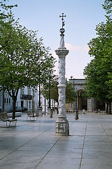
- The Pelourinho was erected on the occasion of the granting of town charter in 1517.
- Sao Francisco Monastery
- The Igreja da Misericórdia was originally a market hall, the arcades of which are still preserved in front of the church.
- The Igreja de Santa Maria , possibly founded by the Visigoths , was transformed into a mosque during the Moorish period . After the city was recaptured in 1162, it was converted into a church.
- Núcleo Visigótico Regional Museum in the former church of Santo Amaro , which was built in the 5th century during the Visigoth times and is one of the four oldest churches in Portugal.
- Not far from Beja Castle , at Largo Dr. Lima Faleiro received an arch of the Roman city wall, also in the east of the old town in the Travessa Funda . In the south of the old town there is a noticeably high section of the Roman city wall at the former city gate Porta de Mértola .
- Ermida de Santo André
- outside
- Roman dam Muro da Prega
- Roman villa of Pisões
Bullfight in Beja 1994
administration
circle
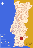
Beja is the capital of the Beja district and the administrative seat of a district ( concelho ). The neighboring districts are (starting clockwise in the north): Cuba , Vidigueira , Serpa , Mértola , Castro Verde , Aljustrel and Ferreira do Alentejo .
With the regional reform in September 2013, several municipalities were merged into new municipalities, so that the number of municipalities decreased from 18 to 9.
The following municipalities ( Freguesias ) are in the Beja district:
| local community | Population (2011) |
Area km² |
Density of population / km² |
LAU code |
|---|---|---|---|---|
| Albernoa e Trindade | 1,032 | 209.38 | 5 | 020519 |
| Baleizão | 902 | 139.74 | 6th | 020502 |
| Beja (Salvador e Santa Maria da Feira) | 11,133 | 22.51 | 495 | 020520 |
| Beja (Santiago Maior e São João Baptista) | 14,015 | 51.27 | 273 | 020521 |
| Beringel | 1,301 | 15.04 | 86 | 020503 |
| Cabeça Gorda | 1,386 | 78.16 | 18th | 020504 |
| Nossa Senhora das Neves | 1,747 | 53.14 | 33 | 020506 |
| Salvada e Quintos | 1,352 | 199.72 | 7th | 020522 |
| Santa Clara de Louredo | 864 | 71.88 | 12 | 020510 |
| Santa Vitória e Mombeja | 981 | 167.10 | 6th | 020523 |
| São Matias | 569 | 70.23 | 8th | 020516 |
| Trigaches e São Brissos | 572 | 68.26 | 8th | 020524 |
| Beja district | 35,854 | 1,146.43 | 31 | 0205 |
Population development
| Population in Beja County (1801–2011) | |||||||||
|---|---|---|---|---|---|---|---|---|---|
| 1801 | 1849 | 1900 | 1930 | 1960 | 1981 | 1991 | 2001 | 2011 | |
| 14,971 | 14,824 | 25,382 | 37.143 | 43,119 | 38,246 | 35,827 | 35,762 | 35,730 | |
Municipal holiday
- Ascension of Christ
Town twinning
traffic
Beja is on the Linha do Alentejo railway line .
The city is integrated in the national bus network of Rede Expressos .
The A26 motorway is to be continued to Beja. So far, Beja has not been directly connected to the country's motorway network. The IP2 leads 53 km south to the A2 . The IP8, here also the national road N260, connects Beja with the A2, at junction no.10 ( Grândola -Sul), also 53 km to the west , and with the border with Spain, which is about 65 km to the east.
The Beja Airport on the premises of the airbase is used for private planes and tourist charter flights since its opening 2011th The expectations could not be met, as no airline has so far included the airport in their route network (as of: winter 2013). However, with the connection to the A26 motorway and the conclusion of contracts, u. a. With cargo and low-cost airlines, those responsible expect an increase in occupancy from 2017.
sons and daughters of the town
- Muhammad al-Mu'tamid ibn Abbad (1040-1095), poet and ruler of the Emirate of Seville
- André de Gouveia (1497–1548), humanist and educator
- Amador Arrais (1530–1600), theologian and writer, Bishop of Portalegre
- Manuel Álvares (1545–1612), doctor, professor at the University of Toulouse
- António Raposo Tavares (1598–1658), Bandeirante in Brazil
- Soror Mariana Alcoforado (1640–1723), nun and writer
- José Agostinho de Macedo (1761–1831), writer and historian
- Carlos Zeferino Pinto Coelho (1819–1893), lawyer and politician, miguelist
- Tomás António Garcia Rosado (1864–1937), military, 1918 commander of the Portuguese Expeditionary Corps in World War I.
- António Maria Baptista (1866–1920), Prime Minister of Portugal
- Mário Beirão (1890–1965), writer, Salazar supporter, lyricist of the hymn of the regime's youth organization, the Mocidade Portuguesa
- Catarina Eufémia (1928–1954), shot farm worker, symbol of resistance against the Estado Novo dictatorship
- Tonicha (* 1946), singer
- Linda de Suza (* 1948), singer in France
- Fernando Mamede (* 1951), record long-distance runner
- Graça Carvalho (* 1955), engineer and minister
- Custódia Galego (* 1959), actress
- António Machuco Rosa (* 1959), university professor and communication theorist
- José António Falcão (* 1961), university professor, historian and museologist
- Pedro Caixinha (* 1970), successful soccer coach, especially in Mexico
- Carlos Moedas (* 1970), civil engineer, economist and politician
- Ana Cabecinha (* 1984), Olympic track and field athlete
- Anna Julia Kapfelsperger (* 1985), German actress
- Tiago Targino (* 1986), football player
- Isaac Alfaiate (* 1988), model and actor
- João Miguel Coimbra Aurélio (* 1988), football player
Mariana Alcoforado (drawing by Modigliani )
Carlos Zeferino Pinto Coelho (caricature by Rafael Bordalo Pinheiro , 1881)
Web links
- City administration website (Portuguese)
- Museu Regional de Beja
- Beja Polytechnic Institute
- RailFanEurope.net shows pictures of the Beja train station
Individual evidence
- ↑ a b www.ine.pt - indicator resident population by place of residence and sex; Decennial in the database of the Instituto Nacional de Estatística
- ↑ a b Overview of code assignments from Freguesias on epp.eurostat.ec.europa.eu
- ↑ Beja Online, História ( Memento of the original from June 1, 2007 in the Internet Archive ) Info: The archive link was inserted automatically and has not yet been checked. Please check the original and archive link according to the instructions and then remove this notice. .
- ↑ María Helena da Cruz Coelho, Manuel Fernández Álvarez , Slobodan Pajovic and others: Pueblos, naciones y estados en la historia. Universidad de Salamanca, 1994, p. 20.
- ^ Wilhelm Voss-Gerling: Portugal. Munich 1972, p. 57.
- ^ Publication of the administrative reorganization in the Diário da República gazette of January 28, 2013, accessed on March 16, 2014
- ↑ www.anmp.pt , accessed on January 4, 2012


