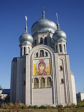
Berezan (city)
| Berezan | ||
| Березань | ||

|
|
|
| Basic data | ||
|---|---|---|
| Oblast : | Kiev Oblast | |
| Rajon : | District-free city | |
| Height : | 105 m | |
| Area : | 32.92 km² | |
| Residents : | 16,585 (2018) | |
| Population density : | 504 inhabitants per km² | |
| Postcodes : | 07540-07543 | |
| Area code : | +380 4476 | |
| Geographic location : | 50 ° 19 ′ N , 31 ° 28 ′ E | |
| KOATUU : | 3210400000 | |
| Administrative structure : | 1 city | |
| Address: | вул. Небесної Сотні 1 07540 м. Березань |
|
| Website : | http://www.berezan.in.ua/ | |
| Statistical information | ||
|
|
||
Beresan ( Ukrainian and Russian Березань ) is an independent city in the east of the Ukrainian Oblast of Kiev with around 16,500 inhabitants (2018).
history
The town, first mentioned in 1616, received urban-type settlement status in 1965 and town status in 1981. Since 1993 it has been directly subordinate to the oblast.
The village was visited in October 1843 by Taras Shevchenko , who was here with the ethnographer and folklorist Platon Lukashevich ( Платон Якимович Лукашевич ; 1809-1887) as a guest. Beresan was occupied by Wehrmacht troops between September 16, 1941 and September 21, 1943 .
Geographical location
Beresan lies in the middle of the Rajon Baryschiwka at an altitude of 105 m on the bank of the Nedra ( Недра ), a 61 km long, left tributary of the Trubisch , about 70 km east of Kiev . The M 03 / E 40 highway runs through the city between Kiev and Kharkiv . North of the city center, Berezan has had a train station on the Kiev – Poltava line since 1901 .
Partnerships
- Together with the Baryschiwka Rajon , Beresan has been a twin town of Pullach in the Isar Valley ( Germany ) since 1990 .
Web links
- Municipal Council website on rada.info (Ukrainian)
Individual evidence
- ↑ Cities and Settlements in Ukraine on pop-stat.mashke.org ; accessed on December 22, 2018
- ↑ a b Local history of Beresan in the history of the cities and villages of the Ukrainian SSR ; accessed on 2018 (ukrainian)


