
Bolshoye Murashkino (Nizhny Novgorod)
| Urban-type settlement
Bolshoye
Murashkino Большое Мурашкино
|
||||||||||||||||||||||||||||||
|
||||||||||||||||||||||||||||||
|
||||||||||||||||||||||||||||||
.svg)
.svg)
Bolshoye Murashkino ( Russian Большо́е Мура́шкино ) is an urban-type settlement in the Nizhny Novgorod Oblast in Russia with 5554 inhabitants (as of October 14, 2010).
geography
The place is located about 80 km as the crow flies southeast of the Nizhny Novgorod Oblast Administrative Center on the right-hand Volga tributary Sundowik .
Bolshoye Muraschkino is the administrative center of the Rajons Bolschmuraschkinski and seat and only town of the municipality (gorodskoje posselenije) Rabotchi possjolok Bolshoye Muraschkino.

Local panorama

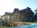
Brothers Monew House from the 19th century (now a museum)
One of the buildings of the former Zemstvo hospital


history
The place was first mentioned in 1377 in a sales deed of the Suzdal- Nizhny-Novgorod Grand Duke Dmitri Konstantinowitsch. There was later a border fortress to the Kazan Khanate , and the place was considered a city (gorod) until the 17th century . From the end of the 18th century it belonged as a village and seat of a Volost to the Ujesd Knjaginin of the Nizhny Novgorod governorate .
On June 29, 1929 Bolshoye Murashkino became the administrative seat of a newly created Rajons named after him. In 1959 the place received the status of an urban-type settlement.
Population development
| year | Residents |
|---|---|
| 1897 | 5341 |
| 1939 | 5336 |
| 1959 | 4850 |
| 1970 | 6335 |
| 1979 | 6845 |
| 1989 | 6728 |
| 2002 | 6377 |
| 2010 | 5554 |
Note: census data
traffic
The regional road 22K-0162 runs through Bolshoye Murashkino and branches off a good 25 km north of the federal highway M7 Moscow - Nizhny Novgorod - Kazan - Perm / Ufa and continues to Knjaginino, Sergach and the border of the Chuvash Republic (towards Alatyr ). First to the west in Bolshoye Murashkino the 22K-0052 branches off to the southwest neighboring district center of Perewos , to the south the 22K-0054 to the neighboring district center Buturlino . The nearest train station Smagino on the Moscow - Arsamas - Kazan line is about 25 km away .
Web links
Individual evidence
- ↑ a b Itogi Vserossijskoj perepisi naselenija 2010 goda. Tom 1. Čislennostʹ i razmeščenie naselenija (Results of the All-Russian Census 2010. Volume 1. Number and distribution of the population). Tables 5 , pp. 12-209; 11 , pp. 312–979 (download from the website of the Federal Service for State Statistics of the Russian Federation)