Bucka (Greiz)
|
Bucka
City of Greiz
Coordinates: 50 ° 38 ′ 0 ″ N , 12 ° 9 ′ 19 ″ E
|
||
|---|---|---|
| Height : | 394 m above sea level NN | |
| Postal code : | 07973 | |
| Area code : | 03661 | |
|
Location of Bucka in Thuringia |
||
|
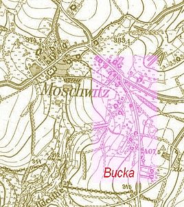
Moschwitz and Bucka
|
||
Bucka was a hamlet in Moschwitz , part of the city of Greiz in the district of Greiz in Thuringia . After growing together with Moschwitz and Kleinmoschwitz, it was absorbed in this place.
history
The village "Buckau" was first mentioned in 1448. There is also a document from March 13, 1614. Bucka was located southeast of the city of Greiz on a plateau of the White Elster Lowlands with Moschwitz. In the west and north-west of the settlement there was Moschwitz, north and east the Grochlitzer Flur. To the south there was a connection to Tremnitz and across the state border with Saxony to Noßwitz and Elsterberg .
The settlement area today forms an economically important part of Moschwitz with the "RIMA Agrofarm". The name of the main street K 204 "Buckestraße" indicates the old name .
Individual evidence
- ^ Wolfgang Kahl : First mention of Thuringian towns and villages. A manual. Rockstuhl Verlag, Bad Langensalza, 2010, ISBN 978-3-86777-202-0 , p. 44

