
Burgstall Stauf
| Burgstall Stauf | ||
|---|---|---|
 Image 1: View into the trench section (December 2013) |
||
| Alternative name (s): | Staufenberg | |
| Creation time : | High medieval | |
| Castle type : | Höhenburg, summit location | |
| Conservation status: | Disappeared, ring wall and section ditch preserved | |
| Place: | Neumarkt in the Upper Palatinate - Stauf - "Staufer Berg" | |
| Geographical location | 49 ° 15 '44.1 " N , 11 ° 25' 31.4" E | |
| Height: | 512 m above sea level NN | |
|
||

The Burgstall Stauf or Staufenberg is the remnant of an abandoned high medieval castle. It is located above Stauf , a district of Neumarkt in the Upper Palatinate , on the summit plateau of the Staufer Berg . Only a few historical dates of the castle nobility from the late Middle Ages are known of the complex. No building structure has been preserved from the castle itself, only a ring wall around the entire plateau and a mighty section ditch that divided the summit plateau can still be seen. This high medieval castle complex could possibly have been built in place of an older fortification.
Geographical location

The castle site is located in the central area of the Frankenjura low mountain range , at 512 m above sea level. NN high Staufer mountain , an oval and east-west facing Zeugenberg . The free-standing mountain drops steeply about 80 meters on all sides .
The Burgstall is located around 730 meters west-southwest of the local church of St. Walburga in Stauf or around 3100 meters southwest of downtown Neumarkt in the Stauf district.
There are other former medieval or prehistoric castles in the vicinity: around 3.1 kilometers north-northwest of the castle site is the Pölling Castle near Rittershof. The Heinrichsbürg castle ruins are located about 4.9 kilometers to the north on a hilltop of the Schlossberg, and the Wolfstein castle ruins are six kilometers to the northeast . There was also a castle in Neumarkt, today's Count Palatinate Palace . There was direct eye contact from Stauf or Staufenberg Castle to Mönning Castle, 8.4 kilometers to the south-west, which is now Möningerberg Castle Stables .
A very large prehistoric ring wall is located on the Buchberg to the south, another prehistoric and prehistoric fortification, which also had a castle in the Middle Ages, was located above the town of Deining , about nine kilometers to the southeast. Another castle site was 9.3 kilometers to the east, the Rothenfels castle stable near the place of the same name.
history
To date, no information is known about the castle on the Staufer Berg, also called Staufenberg in earlier documents . Only the Burgadel was mentioned in 1410 with a Staufer von Staufenberg, she was then married to Friedrich von Raitenbuch. The Raitenbucher family of ministers who served the diocese of Regensburg also built Hohenfels Castle and Ehrenfels Castle . Even Albert III. von Stauffenberg , bishop of Regensburg from 1409 to 1421, belongs to this family.
Presumably the Hans and Dietrich von Staufenberg mentioned in 1424 and 1427 also belonged to this castle nobility. The high medieval castle could probably have been built in the area of an earlier ring wall. When the castle was built, the ring wall was used and the section ditch was created.
Today the former castle is registered as a ground monument D-3-6734-0038 "Medieval Castle Stables" by the Bavarian State Office for Monument Preservation .
description
The castle is located on the oval summit plateau of the Staufer Berg (Fig. 2), which is surrounded by a ring wall. The wall lies about eight meters below the plateau of the mountain and forms a ditch to this mountain top as an additional obstacle to approach. Today the wall is still up to 2.5 meters high, but in some places it is completely flattened and eroded into a slope terrace (Fig. 4 and 5). The best-preserved areas are on the northeast side (Fig. 6) and the western tip of the mountain (Fig. 7), on the southeast side the wall is almost completely exposed today (Fig. 8). The hilltop, which rises steeply from the ring ditch formed in this way, is divided into two parts by a section ditch about eight meters deep and straight from north to south (Fig. 1, 3 and 9) into a slightly larger western and an eastern area. It also pierces the ring wall on the north side (Fig. 6). At the northern (Fig. 10) as well as the southern end of this trench, overburden mounds are visible, the northern one being rather smaller and the northern one being rather large.
The high medieval castle stood on the approximately 80 by 50 meter large area on the west side, to the east of the moat there was possibly a bailey . The relatively flat terrain of the castle, which only slopes slightly towards the edges, no longer shows any special features or traces of former buildings, only on the edge of the slope in the south a barely recognizable step could indicate this.

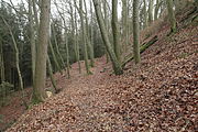
Image 4: Heavily eroded section of the ring wall on the northwest side of the mountain cone (December 2013)
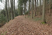
Photo 5: Section of the ring wall flattened to a terrace on the southwest side of the mountain cone (December 2013)

Fig. 6: The ring wall section pierced by the trench on the north side of the mountain cone, on the right the ascent to the outer bailey area (December 2013)
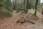
Figure 7: Section of the ring wall at the western tip of the mountain cone (December 2013)

Photo 8: Eastern tip of the outer bailey, on the left the ring wall is exposed (December 2013)

Figure 9: Profile of the trench section, view to the north (December 2013)

Photo 10: Northern overburden mound of the section trench (December 2013)


literature
- Herbert Rädle: Castles and fortress stables in the Neumarkt district . Published by the district of Neumarkt in der Oberpfalz, Neumarkt approx. 2001, ISBN 3-920142-14-4 , pp. 111–113.
- Armin Stroh : The prehistoric and early historical monuments of the Upper Palatinate . (Material booklets on Bavarian prehistory, series B, volume 3). Verlag Michael Lassleben, Kallmünz 1975, ISBN 3-7847-5030-3 , pp. 205-206.
Web links
Individual evidence
- ↑ Armin Stroh: The prehistoric and prehistoric terrain monuments of the Upper Palatinate , p. 206.
- ^ Location of the Burgstall in the Bavaria Atlas
- ^ Herbert Rädle: Castles and castle stables in the Neumarkt district , p. 112 f.
- ↑ Armin Stroh: The prehistoric and prehistoric terrain monuments of the Upper Palatinate , p. 206.
- ↑ List of monuments for Neumarkt in der Oberpfalz (PDF) at the Bavarian State Office for Monument Preservation (PDF; 149 kB)


Castles: Berg Castle | Breitenbrunn Palace | Deining Castle | Deinschwang Castle | Dietfurt Palace (exited) | Erasbach Castle | Froschau Castle (exited) | Grünstein Castle (exited) | Herrnried Castle | Holnstein Castle (exited) | Ittelhofen Castle (exited) | Jettenhofen Castle | Kago Castle | Kirchenödenhart Castle (exited) | Schloss Lauf (exited) | Pfalzgrafenschloss Neumarkt | Oberbürg Castle (exited) | Oberlauterhofen Castle (exited) | Oberrohrenstadt Castle | Ottmaring Castle (exited) | Pilsach Castle | Pollanten Castle | Teutonic Order Castle Postbauer-Heng | Pyrbaum Castle (exited) | Raitenbuch Castle (exited) | Rohrenstadt Castle | Staufersbuch Castle (exited) | Thannbrunn Palace | Upper Töging Castle | Lower Töging Castle (exited) | Wappersdorf Castle | Woffenbach Castle (exited)
Castles and ruins: Castle ruins Adelburg (Adelnburg) | Breitenegg castle ruins | Burggriesbach Castle (exited) | Burg Mauer (Burg Schellenstein) (dismissed) | Frickenhofen Castle (exited) | Habsberg Castle (exited) | Haimburg castle ruins | Heinrichsbürg castle ruins (Heinzburg) | Helfenberg castle ruins | Hohenburg castle ruins | Hohenfels castle ruins | Burg Holnstein (Burgstall Bäckerberg) (removed) | Kemnathen Castle (exited) | Laaber Castle (exited) | Loderbach Castle (exited) | Lupburg Castle | Lützelburg Castle (exited) | Lutzmannstein castle ruins | Castle ruins of Niedersulzbürg | Obersulzbürg castle ruins | Castle ruin Ödenburg | Parsberg Castle | Plankenstein Castle (exited) | Pölling Castle (exited) | Rothenfels Castle (exited) | Schauerstein Castle (exited) | Thannhausen Castle (exited) | Burg Stauf (Burg Staufenberg) (dismissed) | Troßberg Castle (exited) | Castle ruin Velburg | Wappersdorf Castle (Schweppermann ruins) (dismissed) | Wildenstein castle ruins | Wolfstein castle ruins
Tower hill castles (all gone): Burg Grögling | Grubach Tower Hill | Gutser Schloss tower hill | Habertshofen Tower Hill | Oedenthurn tower hill
Manor: Manor Berg (sold) | Hackenhofen manor (dismissed) | Noble seat Leutenbach (dismissed) | Aristocratic seat Mörsdorf (dismissed) | Unterwall manor (sold) | Wünricht manor
Castle stables (lost, unknown castles): Burgstall Alte Burg (Deining) | Burgstall Altenburg (Bachhaupt) | Burgstall Altenburg (Oberbürg) | Section fortification of the Old Castle (Deinschwang) | Ringwall Buchberg | Burgstall Bergheim | Ringwall oak strike | Section fortification Effersdorf | Section fortification Ernersdorf | Burgstall Frabertshofen | Section fortification Fribertshofen | Burgstall Häferloch (Weidenwang Castle?) | Harenzhofen ring wall | Burgstall Hausraitenbuch | Section fortification Herrenwald | Burgstall Hirschstein | Burgstall Hofberg (Burgstall Old Church) | Hohenbrunnen Castle Stables | Section fortification Leistelberg | Burgstall Kopffelsen | Burgstall Mallerstetten | Burgstall Möningerberg | Burgstall Oedenthurn (Plassenburg?) | Burgstall Ottenberg | Burgstall Pruppach | Burgstall Quakhaus | Burgstall Racklburg | Ringwall Reiselsberg | Burgstall Röschberg | Ringwall Röschberg | Section fortification Schanzberg | Section fortification Schanze (Holnstein) | Schanze section fortification (Neumarkt in der Oberpfalz) | Ringwall Schanze (Eispertshofen) | Burgstall Schweppermannsburg (Thierenstein Castle) | Section fortification Sindelbach | Ringwall Stiglerfelsen | Burgstall Sondersfeld | Burgstall Thürsnacht (Thürstein Castle?) | Section fortification Tischnerberg | Ringwall Wolfsberg | Ringwall Wolkensberg
Fortified churches: Fortified Church Helena (St. Helena) | Trautmannshofen fortified church (name of the Virgin Mary)