Burgstall Frickenhofen
| Burgstall Frickenhofen | ||
|---|---|---|
|
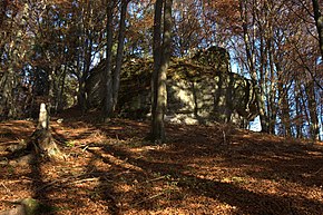
Burgstall Frickenhofen - View of the castle stable and the ring moat from the east |
||
| Creation time : | High Middle Ages | |
| Castle type : | Höhenburg, spur location | |
| Conservation status: | Burgstall | |
| Standing position : | Ministerialenburg | |
| Place: | Neumarkt in the Upper Palatinate-Frickenhofen | |
| Geographical location | 49 ° 16 ′ 47.4 " N , 11 ° 34 ′ 34.7" E | |
| Height: | 550 m above sea level NN | |
|
|
||
The Burgstall Frickenfofen is a small abandoned high medieval local aristocratic castle of the Frickenhof family, which once rose on a rock spur. The Burgstall is located southeast of the village of Frickenhofen, a district of Neumarkt in the Upper Palatinate in Bavaria , Germany . Except for the moat, nothing remains of this castle today.
Geographical location
The castle site of the abandoned Spornburg is located in the Middle Franconian Jura , on a 550 meter high hilltop . A short spur protrudes from this mountain at a north-western corner of the Steinlohe forest department, which also forms the highest point of the mountain. This mountain, which continues like a spur from a high plateau, is bounded in the north by the depression of the Lampertshofener Bach, and in the west by a side valley. Its flanks drop steeply about 70 meters in altitude to the village of Frickenhofen, which is located in the valley floor. The Burgstall is located in a south-easterly direction, about 330 meters away, to the center of Frickenhofen.
There are other former medieval castles in the vicinity, in a south-easterly direction is the Burgstall Plankenstein and to the northeast is the Burgstall Alte Kirche or Jägerhäusl near Unterwiesenacker. To the southwest there are also two castle stables near the village of Rothenfels, to the west above Neumarkt in the Upper Palatinate lies the Wolfstein castle ruins .
history
Little historical information is known about the small castle itself, it was the seat of the Frickenhofer family of service men , they served the Ehrenfelsers in Helfenberg .
The low-nobility family of the Frickenhofer, who had probably also built this castle complex, were wealthy in the area, so they had a second seat with the Allersburg (in the town of the same name near Hohenburg in the Lauterachtal ) from 1342, where they also called themselves “Frickenhofer die Pauren " . They had other possessions in the villages of Hausen , Garsdorf and Mittersdorf (today deserted in the Hohenfels military training area ). Also in Ischhofen , Wiesenacker , Alfalterbach and Sallmannsdorf .
In addition, the Frickenhofer had very close relationships with the Seligenporten monastery , and several daughters of Albrecht I von Frickenhofen were nuns in this monastery . Some members of the family were buried there in the so-called Frickenhoferkapelle, probably a predecessor of today's monastery church. However, their tombstones are lost today. Agnes, the wife of Albrecht I, donated all of her property at Alfalterbach to her son Albrecht Frickenhofer in this chapel on May 25, 1336 . Later members of the Frickenhofer, the “Pauren zu Allersburg”, founded a mass to be read daily in this chapel in 1342 .
The lower aristocratic family probably died out during the second half of the 15th century, the last known members were a Kunigunde Frickenhofer, who donated for the Neumarkt hospital in 1381 , and a Neumarkt mayor named Heinrich Frickenhofer in 1408 .
The castle is likely to have been abandoned after the noble family died out.
description
The location of the castle complex is on the highest point of the mountain at a corner of the mountain from which a rock spur protrudes to the west . This small hilltop castle probably only consisted of a tower-shaped building. However, there is also a shallow, trough-shaped depression immediately to the east, outside of the ring moat, whether it represents the rest of a building of a possible outer bailey is not known. Other fortifications of a bailey such as an outer ditch or the like, however, are completely missing.
The castle site is separated from the slightly lower lying plateau of the mountain by a semicircular ditch (cover picture and picture 3). This trench is still about three meters deep today, and stretches from the southern mountain slope in a circle around the castle hill to the northern slope, which it also accompanies a few meters down.
The castle hill rises several meters very steeply from the moat, on the other hand it drops about five meters vertically over rocks on its west side (Fig. 2 and 3). The relatively flat surface of this hill is roughly rectangular in shape and today no longer shows any traces of former buildings.
Current condition
Today the area of the former castle is densely overgrown by high forest, only the ring moat has survived. Today there is no signposted route to the freely accessible Burgstall.
The ground monument registered by the Bavarian State Office for the Preservation of Monuments as "Medieval Castle Stables " has the monument number D-3-6735-0031.
literature
- Herbert Rädle: Castles and fortress stables in the Neumarkt district . Published by the district of Neumarkt in der Oberpfalz, Neumarkt o. J., ISBN 3-920142-14-4 , pp. 35–37.
Web links
Individual evidence
- ^ The Burgstall on the website of the Bavarian State Office for Monument Preservation
- ^ The Burgstall Rothenfels on the website of the Bavarian State Office for Monument Preservation
- ^ Herbert Rädle: Castles and castle stables in the Neumarkt district , p. 35 ff.
- ^ The Burgstall Frickenhofen on the website of the Bavarian State Office for Monument Preservation


