
Burgstall Häferloch
| Burgstall Häferloch | ||
|---|---|---|
 Burgstall Häferloch - View of the castle hill from the north-west |
||
| Alternative name (s): | Weidenwang | |
| Creation time : | probably 12th century | |
| Castle type : | Höhenburg, hillside location | |
| Conservation status: | Burgstall | |
| Standing position : | Reichsministeriale | |
| Place: | Freystadt -Burggriesbach | |
| Geographical location | 49 ° 8 '29.6 " N , 11 ° 23' 9.7" E | |
| Height: | 529.3 m above sea level NN | |
|
||

The Häferloch castle stable is the remainder of an abandoned , presumably high medieval castle that once stood on a terrace on a steep mountain slope. The Burgstall is located northeast of the parish village of Burggriesbach in the municipality of Freystadt in the Upper Palatinate district of Neumarkt in the Upper Palatinate in Bavaria , Germany . Of the castle, about which not much is known to this day, and which was probably the ancestral castle of the Weidenwanger local nobility, only an impressive castle hill remains.
Geographical location
The site of the former castle is located in the center of the Franconian Alb on a terrace of a very steep north-sloping slope of the Kesselberg. This slope descends towards Weidenwang into the lowland in which the Main-Danube Canal and the Roßbach run today . The Burgstall is located about 2440 meters northeast of the Catholic parish church of Sankt Gangolf in Burggriesbach and 1170 meters south-southwest of the Catholic parish church of Sankt Willibald von Weidenwang.
There are other former medieval castles in the vicinity, just a few kilometers southeast of the Hohenbrunnen castle stables , in a north-westerly direction a castle stables on the Röschberg, and in the nearby Erasbach an aristocratic seat. Another castle stable is located in the nearby Burggriesbach, and in a south-westerly direction the tower hill Gutser Schloss is north of Viehhausen. In the north are the Sulzbürg with the Obersulzbürg castle ruins and the Niedersulzbürg castle stable and a ring wall from the Middle Ages on the 573.1 meter high Schlüpfelberg.
History of the castle
Nothing is known of an early documentary mention of the small castle Häferloch, so that neither the builder nor the time of construction of the castle can be found. The name Häferloch comes from the field name of the same name and probably refers to the deeply cut ravines that are there on the mountain slope.
According to Rädle, it could have been the castle of the local nobility of Weidenwang, which has been attested since the 12th century. The Lords of Weidenwang were imperial ministerials whose task, like that of the imperial ministerials from the nearby Burggriesbach, Sollngriesbach and Erasbach, was to administer the imperial forest for the emperor and the Staufer empire and to settle it after clearing . This forest is still surrounded by the former seats of these Reich ministerials. In addition, the castle was used to monitor a section of the old road that led to the elevated road on the plateau. Immediately in front of the castle area, several sunken paths run up the mountainside.
In 1142, with " Gerhard von Widenwangk " a member of the imperial ministerial family was attested for the first time. Later, in 1223, a Konrad and his brother Ulrich von Weidenwang were mentioned. With the end of the Staufer empire, the entire property of the Staufer, including Weidenwang Castle, came into the hands of Bavarian Duke Ludwig the Strict , and the lords of the castle became Bavarian ministerials. In 1318 another Konrad and his wife Elisabeth Loter von Weidenwang were mentioned, they sold their half of the castle in the same year to Hilpolt von Stein ( Hilpoltstein Castle ); the other half belonged to her cousin. A year later, however, the “Weidenwangerin zu Berching and her daughter zu Beilngries ” sued Hilpolt. This half of the castle was owned by Hermann von Thann (Thann Castle ) in 1327 , who sold it to the Seligenporten monastery in the same year .
Because of the frequent changes of ownership within a few years, Rädle suspects that the castle only existed as a ruin at that time. In the same year, King Ludwig the Bavarian gave the monastery permission to demolish the castle and build a monastery courtyard in Weidenwang.
Today the site of the former castle is densely overgrown with forest, only the mighty castle hill with a ring moat surrounding it has survived. The freely accessible castle stable can be reached from Weidenwang via a hiking trail that runs directly past the castle grounds.
The ground monument registered by the Bavarian State Office for the Preservation of Monuments as a medieval castle stable bears the monument number D-3-6834-0083.
description
The place of the abandoned hilltop castle lies on a slope terrace that drops from the upper third of a northern slope of the Kesselberg into a wide valley. Very steep terrain naturally protected the east side of the castle stable, so that there was no need to dig a ditch there. To the north of the Burgstall, the terrain is flat, but criss-crossed by several sunken paths (Fig. 1) that lead directly uphill past the Burgstall. Only after a few meters does the terrace drop steeply down to the valley. The other two sides are raised by the rising slope of the mountain and had to be protected by a deep ditch.
The area of this small, one-piece hillside castle is oval and consists of a ten-meter-high truncated cone-shaped castle hill (title picture) with the dimensions of about 33 × 29 meters. This hill is surrounded on three sides by a U-shaped ring ditch, which is only very shallow in the north (Fig. 2), but still around 10 meters deep on the south and west side (Fig. 3 and 5). This trench was carved out of the pending sandstone , traces of machining can still be seen in the southern part (Fig. 4). Both ends of the ring trench run to the steep eastern slope and form two large overburden mounds (Fig. 6), a sign of the artificial origin of the trench. In the south, where the castle hill is directly elevated by the Kesselberg, a second ditch can be seen, which was in front of the ring ditch and left a wall between the two ditches (Fig. 7). This straight trench, which runs from east to west, ends after a few meters, where it joins a ravine (Fig. 8). Since this path then went north around the moat, it could have formed a second, outer moat through which the path ran uphill.
Remnants of former buildings are no longer available above ground on the castle hill. The plateau of the hill (Fig. 9) is disturbed by a wood discharge path, and in the south and east forms a terrace a few meters lower, which is densely overgrown with spruce (Fig. 10).

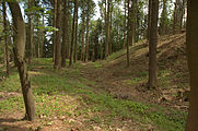
Image 2: View of the heavily flattened northern part of the moat
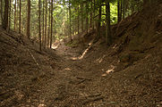
Image 3: View into the deep south-western part of the ring trench, left slope of the castle hill cut out of the terrain

Image 4: Rocks with traces of processing in the southwestern trench area

Image 5: View of the south-eastern part of the moat, the castle area on the left

Photo 6: The northern overburden hill on the steep slope in the east

Fig. 7: On the right the inner ring trench, next to it the outer trench remnant

Image 8: View into the ravine into which the outer ring trench opens

Photo 9: The surface of the castle hill from the northwest

Photo 10: Terrace in the south of the hill


literature
- Herbert Rädle: Castles and fortress stables in the Neumarkt district . Published by the district of Neumarkt in der Oberpfalz, Neumarkt o. J., ISBN 3-920142-14-4 , pp. 129–130.
- Ingrid Burger-Segl: Archaeological Hikes, Volume 2: Middle Altmühltal . Verlag Walter E. Keller, Treuchtlingen 1993, ISBN 3-924828-57-1 , pp. 115-118.
- Armin Stroh : The prehistoric and early historical monuments of the Upper Palatinate . (Material booklets on Bavarian prehistory, series B, volume 3). Verlag Michael Lassleben, Kallmünz 1975, ISBN 3-7847-5030-3 , p. 170.
Web links
Individual evidence
- ^ Topographic map 1: 25000, sheet 6834 Berching
- ^ The Burgstall on the website of the Bavarian State Office for Monument Preservation
- ^ The aristocratic seat on the side of the Bavarian State Office for Monument Preservation
- ^ The Burgstall on the website of the Bavarian State Office for Monument Preservation
- ^ The tower hill Gutser Schloss on the side of the Bavarian State Office for Monument Preservation
- ^ The ring wall on the side of the Bavarian State Office for Monument Preservation
- ^ The Burgstall Häferloch on the website of the Bavarian State Office for Monument Preservation


Castles: Berg Castle | Breitenbrunn Palace | Deining Castle | Deinschwang Castle | Dietfurt Palace (exited) | Erasbach Castle | Froschau Castle (exited) | Grünstein Castle (exited) | Herrnried Castle | Holnstein Castle (exited) | Ittelhofen Castle (exited) | Jettenhofen Castle | Kago Castle | Kirchenödenhart Castle (exited) | Schloss Lauf (exited) | Pfalzgrafenschloss Neumarkt | Oberbürg Castle (exited) | Oberlauterhofen Castle (exited) | Oberrohrenstadt Castle | Ottmaring Castle (exited) | Pilsach Castle | Pollanten Castle | Teutonic Order Castle Postbauer-Heng | Pyrbaum Castle (exited) | Raitenbuch Castle (exited) | Rohrenstadt Castle | Staufersbuch Castle (exited) | Thannbrunn Palace | Upper Töging Castle | Lower Töging Castle (exited) | Wappersdorf Castle | Woffenbach Castle (exited)
Castles and ruins: Castle ruins Adelburg (Adelnburg) | Breitenegg castle ruins | Burggriesbach Castle (exited) | Burg Mauer (Burg Schellenstein) (dismissed) | Frickenhofen Castle (exited) | Habsberg Castle (exited) | Haimburg castle ruins | Heinrichsbürg castle ruins (Heinzburg) | Helfenberg castle ruins | Hohenburg castle ruins | Hohenfels castle ruins | Burg Holnstein (Burgstall Bäckerberg) (removed) | Kemnathen Castle (exited) | Laaber Castle (exited) | Loderbach Castle (exited) | Lupburg Castle | Lützelburg Castle (exited) | Lutzmannstein castle ruins | Castle ruins of Niedersulzbürg | Obersulzbürg castle ruins | Castle ruin Ödenburg | Parsberg Castle | Plankenstein Castle (exited) | Pölling Castle (exited) | Rothenfels Castle (exited) | Schauerstein Castle (exited) | Thannhausen Castle (exited) | Burg Stauf (Burg Staufenberg) (dismissed) | Troßberg Castle (exited) | Castle ruin Velburg | Wappersdorf Castle (Schweppermann ruins) (dismissed) | Wildenstein castle ruins | Wolfstein castle ruins
Tower hill castles (all gone): Burg Grögling | Grubach Tower Hill | Gutser Schloss tower hill | Habertshofen Tower Hill | Oedenthurn tower hill
Manor: Manor Berg (sold) | Hackenhofen manor (dismissed) | Noble seat Leutenbach (dismissed) | Aristocratic seat Mörsdorf (dismissed) | Unterwall manor (sold) | Wünricht manor
Castle stables (lost, unknown castles): Burgstall Alte Burg (Deining) | Burgstall Altenburg (Bachhaupt) | Burgstall Altenburg (Oberbürg) | Section fortification of the Old Castle (Deinschwang) | Ringwall Buchberg | Burgstall Bergheim | Ringwall oak strike | Section fortification Effersdorf | Section fortification Ernersdorf | Burgstall Frabertshofen | Section fortification Fribertshofen | Burgstall Häferloch (Weidenwang Castle?) | Harenzhofen ring wall | Burgstall Hausraitenbuch | Section fortification Herrenwald | Burgstall Hirschstein | Burgstall Hofberg (Burgstall Old Church) | Hohenbrunnen Castle Stables | Section fortification Leistelberg | Burgstall Kopffelsen | Burgstall Mallerstetten | Burgstall Möningerberg | Burgstall Oedenthurn (Plassenburg?) | Burgstall Ottenberg | Burgstall Pruppach | Burgstall Quakhaus | Burgstall Racklburg | Ringwall Reiselsberg | Burgstall Röschberg | Ringwall Röschberg | Section fortification Schanzberg | Section fortification Schanze (Holnstein) | Schanze section fortification (Neumarkt in der Oberpfalz) | Ringwall Schanze (Eispertshofen) | Burgstall Schweppermannsburg (Thierenstein Castle) | Section fortification Sindelbach | Ringwall Stiglerfelsen | Burgstall Sondersfeld | Burgstall Thürsnacht (Thürstein Castle?) | Section fortification Tischnerberg | Ringwall Wolfsberg | Ringwall Wolkensberg
Fortified churches: Fortified Church Helena (St. Helena) | Trautmannshofen fortified church (name of the Virgin Mary)