
Troßberg Castle Stables
| Troßberg Castle Stables | ||
|---|---|---|
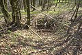
 Burgstall Trossberg - neck moat of the castle, on the left the castle area |
||
| Alternative name (s): | Trossberg, Trosberg | |
| Creation time : | High Middle Ages | |
| Castle type : | Höhenburg, spur location | |
| Conservation status: | Burgstall | |
| Construction: | Ashlar masonry | |
| Place: | Pilsach - Langenmühle | |
| Geographical location | 49 ° 20 '8.9 " N , 11 ° 31' 59" E | |
| Height: | 536 m above sea level NN | |
|
||


The Troßberg castle stable is the remnant of a high to late medieval aristocratic castle that once rose on a mountain spur about 55 meters above the valley floor of the Pilsach. The castle stable of the Spornburg is located north of the village of Tartsberg , immediately west of the Langenmühle in the municipality of Pilsach in the Upper Palatinate district of Neumarkt in the Upper Palatinate in Bavaria , Germany . Only the impressive neck moat and a few remains of the foundation wall have survived from the former district castle .
Geographical location
The site of the former castle is located on a mountain corner of the Schweinberg, surrounded by the upper reaches of the Pilsach, in the central Franconian Alb , a low mountain range in the western Upper Palatinate and in Franconia. This mountain corner forms a rocky spur that descends steeply to the valley, which advances in a south-easterly direction into the Pilsach valley and turns into a plateau on the north-west side. The complex was naturally well protected on three sides, only the north-west side had to be secured by a ditch that was probably mostly naturally created.
The Burgstall is located about 800 meters south of the Herz Jesu chapel in Eispertshofen , or about 200 meters west-southwest of the Langenmühle in the Pilsach valley.
There are a few other former medieval castles nearby, just a few kilometers to the southwest is Pilsach Castle and a little further a castle stable on the 588 meter high Ottenberg, which was the older Pilsach Castle. Another castle in this direction is the Wolfstein castle ruins , 5.5 kilometers away , of which some remains have been preserved. To the south is the lost seat of the Frickenhofer, the Burgstall Frickenhofen , to the east near Hillohe on the 626.6 meter high Dietrichstein there is another castle stable, presumably the castle Thierenstein or Thierstein, today also known as Schweppermannsburg. To the north, near Unterried, was the aristocratic seat of Freyenried, of which only a few remains of masonry are visible, and 6.4 kilometers to the northwest, the Haimburg castle ruins can be visited above the town of the same name.
history
During the High Middle Ages Troßberg Castle was the seat of the bailiffs who ruled the Litzlohe Office, which later became the Pfaffenhofen Care Office. This office consisted of land owned by the Regensburg monastery Sankt Emmeram .
The earlier magistrates were the Counts of Kastl , followed by the Wolfstein family . The Bailiwick of Litzlohe then passed to the Dukes of Bavaria at the end of the 13th century. They installed their ministerials as bailiffs at the castle.
In 1293 a Konrad Senfft is recorded at the castle. They sat at the Pilsach moated castle from around 1322 . One year later, in 1294, “ Rudigerus dictus Furhenriet ” ( Fürnried in the municipality of Birgland ) is sitting in the castle. This magistrate testified for Seyfried Schweppermann .
The last safe owner of the castle is Heinrich der Zenger in 1377, this Bavarian ducal ministerial family also sat at the Velburg and Lutzmannstein castles (today a castle stable in the Hohenfels military training area ). Later another magistrate can be proven, namely in 1487 an Albrecht "Ratz von Freyenried" ( Unterried ), they were a sideline of the Ratz von Eismannsberg .
Current condition
Today the area of the former castle is densely overgrown by high forest, only the neck ditch, a slope ditch with an outer wall and some traces of construction on the castle plateau have survived. The freely accessible Burgstall is located on the “Felsen- und Kreuzwanderweg” between Danlohe and Scheemühle.
The ground monument registered by the Bavarian State Office for the Preservation of Monuments as "Medieval Burgstall" Troßberg "" bears the monument number D-3-6635-0007.
description
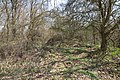
The mountain spur on which the Burgstall is located drops steeply to the valley on three sides (Fig. 1), and on the northwest side merges into a plateau that is at the same height as the Burgplatz. This side is secured by a mighty neck ditch (Fig. 2 and 3), which is slightly curved outwards and runs from the eastern to the southern mountain slope. An outer wall is no longer visible on the plateau, but the neck ditch on the southern steep drop is continued several meters as a slope ditch to which an outer wall was placed (Fig. 4). On the east side of the castle site, a step in the terrain is visible on the slope (Fig. 5), which perhaps served as a kennel , possibly the entrance to the castle was located here.
The Burgplatz itself is located on a triangular rock plateau that has a truncated cone shape. The plateau drops almost vertically towards the neck ditch, the remaining sides are formed by steep slopes, partially interspersed with rocks. The plateau is completely flat on its surface, traces of buildings are numerous as smaller and larger hollows and as hills recognizable (Fig. 6). A slightly larger pit in the western part of the area is certainly the remains of the cellar of a larger building, a small, funnel-shaped depression could possibly mark the plates of a cistern (Fig. 7). Another building stood at the southern tip of the facility (Fig. 8), here a few remains of the foundation wall have survived, which probably belonged to a tower-shaped building. A larger ashlar is still visible from it (Fig. 9).


View into the neck ditch, on the right the castle area

Sloping moat with outer wall on the south side of the castle site

Ramp-like terrain on the east side

Surface of the castle stable
Possible place of a cistern
Location of a building at the southern tip of the facility

Wall block of a building


literature
- Herbert Rädle: Castles and fortress stables in the Neumarkt district . Published by the district of Neumarkt in der Oberpfalz, Neumarkt o. J., ISBN 3-920142-14-4 , p. 122.
- Armin Stroh : The prehistoric and early historical monuments of the Upper Palatinate . (Material booklets on Bavarian prehistory, series B, volume 3). Verlag Michael Lassleben, Kallmünz 1975, ISBN 3-7847-5030-3 , p. 194.
Web links
Individual evidence
- ^ Location of the castle stable in the Bayern viewer
- ^ Topographic map 1: 25000, sheet 6635 Lauterhofen
- ^ The Burgstall Ottenberg on the website of the Bavarian State Office for Monument Preservation
- ^ Burgstall Schweppermannsburg on the website of the Bavarian State Office for Monument Preservation
- ↑ Information board at the Burgstall
- ^ Herbert Rädle: Castles and castle stables in the Neumarkt district, p. 123
- ^ Source history: Herbert Rädle: Castles and castle stables in the Neumarkt district , p. 122
- ^ The Troßberg castle stable on the website of the Bavarian State Office for Monument Preservation


Castles: Berg Castle | Breitenbrunn Palace | Deining Castle | Deinschwang Castle | Dietfurt Palace (exited) | Erasbach Castle | Froschau Castle (exited) | Grünstein Castle (exited) | Herrnried Castle | Holnstein Castle (exited) | Ittelhofen Castle (exited) | Jettenhofen Castle | Kago Castle | Kirchenödenhart Castle (exited) | Schloss Lauf (exited) | Pfalzgrafenschloss Neumarkt | Oberbürg Castle (exited) | Oberlauterhofen Castle (exited) | Oberrohrenstadt Castle | Ottmaring Castle (exited) | Pilsach Castle | Pollanten Castle | Teutonic Order Castle Postbauer-Heng | Pyrbaum Castle (exited) | Raitenbuch Castle (exited) | Rohrenstadt Castle | Staufersbuch Castle (exited) | Thannbrunn Palace | Upper Töging Castle | Lower Töging Castle (exited) | Wappersdorf Castle | Woffenbach Castle (exited)
Castles and ruins: Castle ruins Adelburg (Adelnburg) | Breitenegg castle ruins | Burggriesbach Castle (exited) | Burg Mauer (Burg Schellenstein) (dismissed) | Frickenhofen Castle (exited) | Habsberg Castle (exited) | Haimburg castle ruins | Heinrichsbürg castle ruins (Heinzburg) | Helfenberg castle ruins | Hohenburg castle ruins | Hohenfels castle ruins | Burg Holnstein (Burgstall Bäckerberg) (removed) | Kemnathen Castle (exited) | Laaber Castle (exited) | Loderbach Castle (exited) | Lupburg Castle | Lützelburg Castle (exited) | Lutzmannstein castle ruins | Castle ruins of Niedersulzbürg | Obersulzbürg castle ruins | Castle ruin Ödenburg | Parsberg Castle | Plankenstein Castle (exited) | Pölling Castle (exited) | Rothenfels Castle (exited) | Schauerstein Castle (exited) | Thannhausen Castle (exited) | Burg Stauf (Burg Staufenberg) (dismissed) | Troßberg Castle (exited) | Castle ruin Velburg | Wappersdorf Castle (Schweppermann ruins) (dismissed) | Wildenstein castle ruins | Wolfstein castle ruins
Tower hill castles (all gone): Burg Grögling | Grubach Tower Hill | Gutser Schloss tower hill | Habertshofen Tower Hill | Oedenthurn tower hill
Manor: Manor Berg (sold) | Hackenhofen manor (dismissed) | Noble seat Leutenbach (dismissed) | Aristocratic seat Mörsdorf (dismissed) | Unterwall manor (sold) | Wünricht manor
Castle stables (lost, unknown castles): Burgstall Alte Burg (Deining) | Burgstall Altenburg (Bachhaupt) | Burgstall Altenburg (Oberbürg) | Section fortification of the Old Castle (Deinschwang) | Ringwall Buchberg | Burgstall Bergheim | Ringwall oak strike | Section fortification Effersdorf | Section fortification Ernersdorf | Burgstall Frabertshofen | Section fortification Fribertshofen | Burgstall Häferloch (Weidenwang Castle?) | Harenzhofen ring wall | Burgstall Hausraitenbuch | Section fortification Herrenwald | Burgstall Hirschstein | Burgstall Hofberg (Burgstall Old Church) | Hohenbrunnen Castle Stables | Section fortification Leistelberg | Burgstall Kopffelsen | Burgstall Mallerstetten | Burgstall Möningerberg | Burgstall Oedenthurn (Plassenburg?) | Burgstall Ottenberg | Burgstall Pruppach | Burgstall Quakhaus | Burgstall Racklburg | Ringwall Reiselsberg | Burgstall Röschberg | Ringwall Röschberg | Section fortification Schanzberg | Section fortification Schanze (Holnstein) | Schanze section fortification (Neumarkt in der Oberpfalz) | Ringwall Schanze (Eispertshofen) | Burgstall Schweppermannsburg (Thierenstein Castle) | Section fortification Sindelbach | Ringwall Stiglerfelsen | Burgstall Sondersfeld | Burgstall Thürsnacht (Thürstein Castle?) | Section fortification Tischnerberg | Ringwall Wolfsberg | Ringwall Wolkensberg
Fortified churches: Fortified Church Helena (St. Helena) | Trautmannshofen fortified church (name of the Virgin Mary)