
Burgstall Plankenstein (Velburg)
| Burgstall Plankenstein | ||
|---|---|---|
 South-west corner of the main castle, seen from the lower castle (June 2015) |
||
| Creation time : | before 1196 | |
| Castle type : | Höhenburg, summit location | |
| Conservation status: | Burgstall, ring moat preserved | |
| Standing position : | Episcopal Regensburg Ministeriale | |
| Construction: | Ashlar masonry | |
| Place: | Velburg - Deusmauer - "Plankenstein" | |
| Geographical location | 49 ° 15 '54.3 " N , 11 ° 37' 53.5" E | |
| Height: | 587.8 m above sea level NN | |
|
||

The Burgstall Plankenstein was a presumably high medieval aristocratic castle near the village of Deusmauer , a district of Velburg in the Upper Palatinate district of Neumarkt in the Upper Palatinate in Bavaria , Germany .
The castle stable of the former hilltop castle is freely accessible.
Geographical location
The Outbound hilltop castle was on the 587.8 m above sea level. NN meter high summit of the mountain of the same name, which rises on the eastern edge of the valley of the Schwarzen Laber (Fig. 3). The Burgstall is located about 1,450 meters north-northeast of the Catholic parish church in the village of Deusmauer and 13 kilometers east of Neumarkt in the Upper Palatinate.
You can reach the Burgstall from the Velburg exit of the federal motorway 9 , which passes it to the west, by driving north. From Deusmauer the rest of the way has to be covered on foot.
Nearby there are other former medieval castles, to the south the ruins of Velburg and Helfenburg and the ruins of Adelburg , to the north the Schanzberg castle stables and the old church at Unterwiesenacker, as well as the Lützelburg and Habsberg castle stables , on which the pilgrimage church stands today.
History of the castle
Not much is known about Plankenstein Castle. Between 1196 and 1207 a landlord von Plankenstein, Bischöflich-Regensburger Ministeriale is mentioned as the owner of the castle. From around 1300 the castle belonged to the Ehrenfelsern zu Helfenberg, who sold it to Count Palatine Ruprecht I in 1374 .
Today the place of the castle, near which there is an unmarked forest path, is densely wooded. Only the moat with outer wall has been preserved.
The castle site is protected as a ground monument number D-3-6735-0048: "Medieval Castle Stable Plankenstein".
description
The castle site is located on the highest point of the Plankenstein of the same name, on a dolomite rock reef towering over the surrounding area (Fig. 3). The former castle was divided into an upper castle or core castle on the small summit plateau of the mountain and a lower castle or outer castle on the southwest corner of the core castle.
The area of the core castle falls vertically on the west side, partly overhanging rocks (Fig. 4). The northern slope is also largely secured by rockfalls, only where these rocks form a gap and the terrain slopes very steeply are the last remnants of broken brickwork (Fig. 5). Further down on the slope you can still find the fallen cuboids of this wall (Fig. 6). The south side of the main castle also drops very steeply for several meters (cover picture and picture 7), only the most endangered east side and the north-east corner had to be additionally fortified. A ring trench was placed on this side, which rises only a few meters, and the remaining railing in front of this trench forms an outer wall (Fig. 2). The area of the irregular inner castle measures about 40 by 30 meters. The masonry is no longer preserved in the entire castle area, the only remnant of the former building is a hollow on the east side of the core castle, probably the place of a building of the castle (Fig. 8).
The outer bailey is located on the southwest corner of the inner bailey, a few meters lower than it. Here, too, only a hollow has been preserved as the last remnant of the development (Fig. 9). At the foot of the western rock face is a small cave that was either artificially created or largely reworked (Fig. 4 and 10). This grotto is around four meters deep and 3.5 meters wide and was probably used as a cellar by the castle residents. Immediately to the south of the grotto there is also a tapering abri (rock roof) (title picture, pictures 4 and 10).
photos

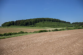
Image 3: View of the gently sloping plank stone from the east (June 2015)

Photo 4: Cave and Abri on the west side of the core castle (June 2015)
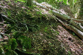
Photo 5: Worn masonry on the northern slope of the core castle (June 2015)

Fig. 6: Wall cuboid at the foot of the northern slope of the main castle (July 2012)

Photo 7: Rocks at the southwest corner of the core castle (June 2015)

Image 8: View over the main castle plateau, in the background a small hollow, probably the location of a building (June 2015)
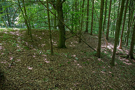
Image 9: Mulde in the area of the outer bailey (June 2015)

Photo 10: West side of the core castle with a small cave and abri. In the background the location of the outer bailey. (June 2015)


literature
- Herbert Rädle: Castles and fortress stables in the Neumarkt district. Published by the district of Neumarkt in der Oberpfalz, Neumarkt o. J., ISBN 3-920142-14-4 , pp. 86–87.
- Armin Stroh : The prehistoric and early historical monuments of the Upper Palatinate . (Material booklets on Bavarian prehistory, series B, volume 3). Verlag Michael Lassleben, Kallmünz 1975, ISBN 3-7847-5030-3 , p. 166.
Web links
References and comments
- ^ Location of the Burgstall in the Bavarian Monument Atlas
- ^ The Burgstall on the website of the Bavarian State Office for Monument Preservation
- ^ The Burgstall on the website of the Bavarian State Office for Monument Preservation
- ^ The Burgstall on the website of the Bavarian State Office for Monument Preservation
- ^ Source history: Herbert Rädle: Castles and castle stables in the Neumarkt district, p. 86 ff.
- ↑ List of monuments for Velburg (PDF) at the Bavarian State Office for Monument Preservation (PDF; 167 kB)
- ↑ This outer bailey is not mentioned in either Rädle or Stroh
- ^ Source description: Armin Stroh: The prehistoric and prehistoric terrain monuments of the Upper Palatinate , p. 166


Castles: Berg Castle | Breitenbrunn Palace | Deining Castle | Deinschwang Castle | Dietfurt Palace (exited) | Erasbach Castle | Froschau Castle (exited) | Grünstein Castle (exited) | Herrnried Castle | Holnstein Castle (exited) | Ittelhofen Castle (exited) | Jettenhofen Castle | Kago Castle | Kirchenödenhart Castle (exited) | Schloss Lauf (exited) | Pfalzgrafenschloss Neumarkt | Oberbürg Castle (exited) | Oberlauterhofen Castle (exited) | Oberrohrenstadt Castle | Ottmaring Castle (exited) | Pilsach Castle | Pollanten Castle | Teutonic Order Castle Postbauer-Heng | Pyrbaum Castle (exited) | Raitenbuch Castle (exited) | Rohrenstadt Castle | Staufersbuch Castle (exited) | Thannbrunn Palace | Upper Töging Castle | Lower Töging Castle (exited) | Wappersdorf Castle | Woffenbach Castle (exited)
Castles and ruins: Castle ruins Adelburg (Adelnburg) | Breitenegg castle ruins | Burggriesbach Castle (exited) | Burg Mauer (Burg Schellenstein) (dismissed) | Frickenhofen Castle (exited) | Habsberg Castle (exited) | Haimburg castle ruins | Heinrichsbürg castle ruins (Heinzburg) | Helfenberg castle ruins | Hohenburg castle ruins | Hohenfels castle ruins | Burg Holnstein (Burgstall Bäckerberg) (removed) | Kemnathen Castle (exited) | Laaber Castle (exited) | Loderbach Castle (exited) | Lupburg Castle | Lützelburg Castle (exited) | Lutzmannstein castle ruins | Castle ruins of Niedersulzbürg | Obersulzbürg castle ruins | Castle ruin Ödenburg | Parsberg Castle | Plankenstein Castle (exited) | Pölling Castle (exited) | Rothenfels Castle (exited) | Schauerstein Castle (exited) | Thannhausen Castle (exited) | Burg Stauf (Burg Staufenberg) (dismissed) | Troßberg Castle (exited) | Castle ruin Velburg | Wappersdorf Castle (Schweppermann ruins) (dismissed) | Wildenstein castle ruins | Wolfstein castle ruins
Tower hill castles (all gone): Burg Grögling | Grubach Tower Hill | Gutser Schloss tower hill | Habertshofen Tower Hill | Oedenthurn tower hill
Manor: Manor Berg (sold) | Hackenhofen manor (dismissed) | Noble seat Leutenbach (dismissed) | Aristocratic seat Mörsdorf (dismissed) | Unterwall manor (sold) | Wünricht manor
Castle stables (lost, unknown castles): Burgstall Alte Burg (Deining) | Burgstall Altenburg (Bachhaupt) | Burgstall Altenburg (Oberbürg) | Section fortification of the Old Castle (Deinschwang) | Ringwall Buchberg | Burgstall Bergheim | Ringwall oak strike | Section fortification Effersdorf | Section fortification Ernersdorf | Burgstall Frabertshofen | Section fortification Fribertshofen | Burgstall Häferloch (Weidenwang Castle?) | Harenzhofen ring wall | Burgstall Hausraitenbuch | Section fortification Herrenwald | Burgstall Hirschstein | Burgstall Hofberg (Burgstall Old Church) | Hohenbrunnen Castle Stables | Section fortification Leistelberg | Burgstall Kopffelsen | Burgstall Mallerstetten | Burgstall Möningerberg | Burgstall Oedenthurn (Plassenburg?) | Burgstall Ottenberg | Burgstall Pruppach | Burgstall Quakhaus | Burgstall Racklburg | Ringwall Reiselsberg | Burgstall Röschberg | Ringwall Röschberg | Section fortification Schanzberg | Section fortification Schanze (Holnstein) | Schanze section fortification (Neumarkt in der Oberpfalz) | Ringwall Schanze (Eispertshofen) | Burgstall Schweppermannsburg (Thierenstein Castle) | Section fortification Sindelbach | Ringwall Stiglerfelsen | Burgstall Sondersfeld | Burgstall Thürsnacht (Thürstein Castle?) | Section fortification Tischnerberg | Ringwall Wolfsberg | Ringwall Wolkensberg
Fortified churches: Fortified Church Helena (St. Helena) | Trautmannshofen fortified church (name of the Virgin Mary)