
Cordoba Province (Argentina)
| Basic data | |
|---|---|
 ( Details ) |
 ( Details ) |
| Capital: | Cordoba |
| Surface:
- Total |
Rank 5 of 24 165,321 km² |
|
Population :
- Total 2010 |
Rank 2 of 24
3,308,876 inhabitants |
 .svg) |
|
| ISO 3166-2 code: | AR-X |
| politics | |
| Region : | Centro region |
| Structure: | 26 departments |
| Gobernador: | Juan Schiaretti |
| Website of the Province of Cordoba | |
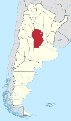
The province of Cordoba is located in central Argentina a little north of its geographical center, which is why it is sometimes also called the "heart of Argentina". Cordoba is one of the more densely populated and economically important areas of the country. Its capital, which is also called Cordoba and gave the province its name, is the second largest city in Argentina and an important industrial center.
Córdoba borders in the north on Santiago del Estero , in the east on Santa Fe , in the southeast on Buenos Aires , in the south on La Pampa , in the southwest on San Luis , in the west on La Rioja and in the northwest on Catamarca .
geography
From a geographical point of view, the province consists of two parts: the mountainous west with the Sierras de Córdoba , which belongs to the Sierras Pampeanas , and the flat east, half each belonging to the Pampa and Chaco plains.
Mountains
The Sierras de Córdoba consist of three mountain ranges running in a north-south direction: the Sierra Grande in the west, the Sierra Chica in the east and the Sierra de los Comechingones , which connects to both of the aforementioned mountain ranges to the south. Several, lower side ranges branch off from these three main mountain ranges; the most important are the Sierra de Ambargasta in the north of the Sierra Chica and the Sierra de Pocho in the west of the Sierra Grande.
The highest peaks are the Cerro Champaquí (2790 m) in the Sierra Grande and the Cerro Los Gigantes (2370 m) in the Sierra Grande, the highest point of the Sierra Chica is the Uritorco (1979 m). Between the individual sierren there are three valleys running in north-south direction, the Valle de Punilla , the Valle de Calamuchita and the Valle de Traslasierra , as well as plateaus at 1500-2000 meters altitude, the so-called pampas serranas , which have barren vegetation and are only very sparsely populated.
Levels
The plains to the east are the most densely populated area of the province. It is geographically divided into the areas in the north around the Río Dulce and Lake Mar Chiquita , which are included in the Gran Chaco , and in the south, which belongs to the pampas . The boundary between the two vegetation zones cannot be precisely defined, as the plain is used intensively for agriculture and therefore hardly any original vegetation has been preserved; it used to be south of the city of Córdoba, but dry forests like the Chaco are now only to be found north of the city of Deán Funes (approx. 100 km north of Córdoba).
Waters
The most striking body of water in the province is Lake Mar Chiquita in the northeast of the province, which is the largest in Argentina and the second largest in South America with an area of 5,770 square kilometers. It has no drainage and is salty and drains a large area in northwest Argentina. The most important tributaries are the Río Dulce in the north and the Río Suquía or Río Primero and the Río Xanaes or Río Segundo in the south.
Two other rivers cross the province from west to east: the Río Ctalamochita (Río Tercero) and the Río Chocancharava (Río Cuarto); they unite in the east of the province to the Río Saladillo , which flows into the Río Paraná . In the extreme south of Córdoba the Río Popopis (Río Quinto) also flows from west to east, but it dries up in a swamp area in the southeast of the province.
Several artificial reservoirs dam the respective rivers. The largest are the Embalse Río Tercero (near Embalse ), the Embalse Cruz del Eje in the northwest, the Embalse Ingeniero Medina Allende in the west, the Embalse Los Molinos in the center and the Embalse San Roque near Villa Carlos Paz .
climate
The climate in the low-lying parts of the province is temperate with warm to hot, humid summers (22 ° -26 ° C average temperature) and mild, extremely dry winters (10 ° -13 ° C average temperature, with large fluctuations between day and night) which often lead to forest fires. The plains west of the Sierras are drier than those in the east with 750 to 850 mm due to the prevailing easterly winds with around 550 mm of precipitation per year. The Pampas Serranas and the high elevations of the Sierras have a harsh climate with cool summers (15 ° C) and cold winters (5 ° C) with frequent, but mostly only weak snowfalls.
Flora and fauna
Little of the original flora has been preserved in the plains; the areas around the Salinas Grandes salt desert in the north-west of the province are the most pristine , as there is no agriculture there due to the poor quality of the soil. The Sierras de Córdoba are also largely in a natural state outside the tourist zones. Both in the plains and in the mountains, low trees and thorn bushes dominate.
Wild animals include big cats such as the puma , the mountain cat and the rare yaguareté , a type of jaguar . In the south there are also deer and roe deer . The most famous bird is the Andean condor , which is found in the Sierras Grandes and Sierras de Comechingones.
Nature reserves
There is only one national park in the province, the Quebrada del Condorito National Park , which is located in the Sierras Grandes and protects the area around a gorge in which a particularly large number of condors nest. Significant nature reserves under the administration of the province are the nature reserve swamps of the Río Dulce and Mar Chiquita around the lake of the same name, as well as the nature reserve Salinas Grandes in the northwest around the salt pans of the same name. There are also numerous smaller nature reserves in the Sierras de Córdoba.
population
With about 3.3 million inhabitants (2010), the province is the second most important in terms of population in Argentina after the province of Buenos Aires .
The province's population consists mainly of the descendants of immigrants ( Spaniards , Italians , Syrians , Lebanese , Armenians, and Germans ) as well as Argentine immigrants from the northern provinces. Around ten percent are foreigners, mainly from Bolivia and Peru . But there are also numerous foreigners from Europe who have moved to the province because of nature ( migrantes ambientales ).
The natives ( Comechingones in the west and Sanavirones in the east) were sedentary and made use of relatively sophisticated technology. However, they were deported during the colonial period and then exterminated, so that only a few local terms were able to save themselves into modern times. The few remaining mingled with the immigrants through mestizo .
The population growth of 10.3 percent between 1991 and 2001 was, according to the INDEC census, slightly below the national average (10.5%). It should be noted that the tourist-oriented areas in the Sierras de Córdoba are growing significantly faster than the regions in the east of the province. Between 2001 and the 2008 census, growth was 4.9 percent.
The distribution of the population is uneven. In the greater Cordoba area and the eastern Sierras, for example, population densities of over 100 inhabitants per square kilometer can be found, while it is less than 1 on the plateaus of the Sierras and in some areas in the west and northwest. In the east of the province, the rate is fairly even at around 10.
Important cities
With 1.8 million people, more than half of the province's population lives in the greater Cordoba area. There are also many small and medium-sized cities, which are mainly located in the eastern regions, where the population density is highest and relatively evenly distributed apart from the greater Cordoba area. About another third of the population lives in them. Large parts of the west of the province, on the other hand, are almost uninhabited.
In addition to Córdoba as an administrative-industrial center, Río Cuarto (agricultural and chemical industry), Villa María (food industry), San Francisco (commercial center), Villa Carlos Paz ( tourism ) and Río Tercero (chemical and arms industry) are the largest cities in the province. Even if it is much smaller, the city of Arroyito is of particular importance as the seat of the largest group in the province, Arcor . Villa General Belgrano is considered the center of colonization by Germans and is also important today as a tourist destination.
Cities with more than 10,000 inhabitants
Population in brackets (2008 census):
- Cordoba (1,301,572)
- Río Cuarto (155,911)
- Villa María (75,551)
- San Francisco (61,260)
- Villa Carlos Paz (56,970)
- Alta Gracia (46,923)
- Río Tercero (46,167)
- Bell Ville (33,281)
- Villa Dolores (31,193)
- Jesús María (30,727)
- Cruz del Eje (30,586)
- La Calera (30,339)
- Villa Allende (27,164)
- Marcos Juarez (26,452)
- Deán Funes (21,561)
- Arroyito (21,422)
- Laboulaye (20,514)
- Cosquín (19,965)
- Segundo River (19,559)
- Colonia Caroya (19,272)
- Río Ceballos (18,939)
- Villa Nueva (18,268)
- Morteros (16,723)
- Unquillo (16,714)
- Las Varillas (16,124)
- La Falda (15,022)
- Villa del Rosario (14,970)
- Pilar (13,608)
- Oncativo (12,655)
- La Carlota (12,542)
- Malvinas Argentinas (12,484)
- Malagueño (12,461)
- Oliva (12,156)
- Santa Rosa de Calamuchita (12,041)
- General Cabrera (11,321)
- Almafuerte (11,265)
- Hernando (10,875)
- Leones (10,596)
- Vicuña Mackenna (10,412)
- Saldán (10,402)
- Estación Juárez Celman (10,370)
- Corral de Bustos (10,334)
- Capilla del Monte (10,331)
- General Deheza (10,163)
- Brinkmann (10,049)
- Montecristo (10,014)
economy
economic sectors
The province's economy rests on several pillars. There is a lot of industry in the cities (automotive and aircraft industries, mechanical engineering, cement, chemicals, electronics and software in Cordoba, agribusiness and chemicals in Río Cuarto and Villa María), and agriculture and livestock are successful on the plains to the east and south operated. In the field of energy generation, the province of Córdoba is one of the front runners in Argentina, with several reservoirs and the country's largest nuclear power plant in Embalse , which is notorious for several incidents.
tourism
Tourism plays a major role in the province. The Sierras de Córdoba are the second most popular travel area in Argentina after the Argentine Atlantic coast, with around three million visitors per year. In addition to the provincial capital, the main tourist centers are Villa Carlos Paz , Cosquín , La Falda , Villa General Belgrano and Mina Clavero , where you can swim, hike and do various sporting activities in crystal clear rivers. Another tourist center is the Laguna Mar Chiquita in the northeast of the province.
Economic situation
The province has an average level of gross national product per capita in Argentina, but the distribution of national income among the various classes is relatively even; therefore, the poverty rate and the so-called misery rate (a lower poverty rate that is used in Argentina and describes the population with particularly low incomes) are lower than the national average.
Generally speaking, there is a north-west-south-east divide, with the south-east (around Río Cuarto ) being the richest, while in the north-west the poverty rate is well above average. Further islands of prosperity are to be found in the Sierras, especially in places that are successful in tourism and whose traditional residents have been joined by urban refugees from the upper income brackets.
Transport and infrastructure
The province has good transport links in almost all regions, with the exception of parts of the Sierras de Córdoba and the extreme north-west.
There is an international airport in Córdoba itself, the Aeropuerto Internacional Ingeniero Taravella , also known as Pajas Blancas . There are other airports in Río Cuarto, Villa María, Villa Dolores and La Cumbre, but they have no regular scheduled flights.
The road network is star-shaped towards the capital Córdoba. Motorways and motorway-like expressways are located between Córdoba and Villa Carlos Paz and between Córdoba and Villa María (partly still under construction, planned connection to Rosario ). The Córdoba - Jesús María line is under construction . The plan is for Río Cuarto - Las Higueras, Córdoba - San Francisco , Córdoba - Río Cuarto and the expansion of the south east-west connection Ruta Nacional 7 ( Buenos Aires - Mendoza ). Also worth mentioning is the Ruta Nacional 20 between Villa Carlos Paz and Mina Clavero , called Camino de las Altas Cumbres , which was only completed in the 1990s and leads over a plateau up to 2,000 meters high in the Sierras Grandes .
The rail network is also geared towards the provincial capital, but has been in a very poor condition since the early 1990s. There are only two routes served by a passenger train (Córdoba - Villa María - Rosario - Buenos Aires and Córdoba - Cosquín ).
Administrative division
The province of Córdoba is divided into 26 departments , which in turn are subdivided into Municipios (larger municipalities over 2,000 inhabitants) and Comunas (smaller municipalities). The Municipios are headed by an Intendente , while the Comunas are headed by a Jefe Comunal . According to the provincial constitution, a municipality can apply for city rights if it has more than 10,000 inhabitants.
| Department | surface | Population (2010 census) | Population density | Capital | Population capital (2001 census) |
|---|---|---|---|---|---|
| Calamuchita | 4,642 | 54,730 | 11.8 | San Agustin | 3,588 |
| Capital | 562 | 1,329,604 | 2,365.8 | Cordoba *) | 1,301,572 |
| Colón | 2,588 | 225.151 | 87.0 | Jesús María | 30,727 |
| Cruz del Eje | 6,653 | 58,759 | 8.8 | Cruz del Eje | 30,586 |
| General Roca | 12,659 | 35,645 | 2.8 | Villa Huidobro | 5,871 |
| General San Martin | 5,006 | 127.454 | 25.5 | Villa María | 75,551 |
| Ischilín | 5.123 | 31,312 | 6.1 | Deán Funes | 21,561 |
| Juarez Celman | 8,902 | 61,078 | 6.9 | La Carlota | 12,542 |
| Marcos Juarez | 9,490 | 104.205 | 11.0 | Marcos Juarez | 26,452 |
| Minas | 3,730 | 4,727 | 1.3 | San Carlos Minas | 1,744 |
| Pocho | 3,207 | 5,380 | 1.7 | Salsacate | 1,872 |
| Presidente Roque Saénz Peña | 8,228 | 36,282 | 4.4 | Laboulaye | 20,514 |
| Punilla | 2,592 | 178,401 | 68.8 | Cosquín | 19,965 |
| Río Cuarto | 18,394 | 246.393 | 13.4 | Río Cuarto | 155.911 |
| Río Primero | 6,753 | 46,675 | 6.9 | Santa Rosa de Río Primero | 7,750 |
| Río Seco | 6,754 | 13,242 | 2.0 | Villa de María | 4,782 |
| Rio Segundo | 4,970 | 103.718 | 20.9 | Villa del Rosario | 14,970 |
| San Alberto | 3,327 | 37.004 | 11.1 | Villa Cura Brochero | 5,680 |
| San Javier | 1,652 | 53,520 | 32.4 | Villa Dolores | 31,193 |
| San Justo | 13,677 | 206307 | 14.8 | San Francisco | 61,260 |
| Santa María | 3,427 | 98,188 | 28.7 | Alta Gracia | 46,923 |
| Sobremonte | 3,307 | 4,591 | 1.4 | San Francisco del Chañar | 2,759 |
| Tercero Arriba | 5,187 | 109,554 | 21.1 | Oliva | 12,156 |
| Totoral | 3,145 | 18,556 | 5.9 | Villa del Totoral | 8,494 |
| Tulumba | 10.164 | 12,673 | 1.2 | Villa Tulumba | 1,495 |
| Union | 11,182 | 105,727 | 9.5 | Bell Ville | 33.281 |
*) The Departamento Capital has only one municipality, the city of Córdoba itself. However, some remote areas of the urban area are not counted as part of the city itself in the INDEC censuses , even if they belong to the same municipality, hence the difference in the number of inhabitants.
Data: Statistics Office INDEC
politics
In the province there has been a de facto three-party system consisting of the PJ , UCR and the regional party Partido Nuevo since 2003 .
Cordoba was traditionally dominated by the Unión Cívica Radical (UCR) party in the 20th century . Since the late 1990s, however, there has been a change in this party, particularly because of corruption scandals; the current governor since 2007, Juan Schiaretti , and his predecessor José Manuel de la Sota (1999-2007) belong to the Partido Justicialista (PJ, also "Peronist Party"), which now has a majority in the Provincial Legislatura . The UCR and PJ, which operates in this province as Unión Por Córdoba (UPC) , are the undisputed dominant in the interior of the country, with the UCR providing most of the mayors in smaller towns.
It was not until 2003, after the Argentina crisis , that the third major actor, the Partido Nuevo (officially: Partido Nuevo Contra la Corrupción - New Party Against Corruption) was founded. Since the fall of the UCR in provincial politics, it sees itself as the first opposition force to Peronism, but works with it to some extent at the national level. The party has a voter potential of around 30 percent, whereby it is most popular in the capital Córdoba itself and has provided the mayor there since 2003 (2003-2007 Luis Juez , the party’s founder, Daniel Giacomino from the end of 2007 ). In 2007, the PN became the strongest force in most areas around the capital. She is currently striving to set up a nationwide party front (initially as Frente Nuevo , since mid-2007 Frente Cívico ), which among others works with the center-left Afirmación para una República Igualitaria (ARI) and Partido Socialista .
Partnerships
The province of Cordoba has had a partnership with the city of Chongqing , People's Republic of China , since 2010 .
Web links
- Provincial government website
- Data from the 2001 census for the province of Cordoba ( Memento of October 15, 2003 in the Internet Archive )
Individual evidence
- ↑ Results of the 2008 census (PDF; 29 kB), source: La Voz del Interior
- ↑ Results of the 2010 census (PDF) Departamentos
- ↑ Preliminary results of the election of September 2, 2007 ( Flash ; 151 kB)
- ^ Chongqing Municipal Government
Coordinates: 32 ° 0 ′ S , 64 ° 0 ′ W
Buenos Aires | Catamarca | Chaco | Chubut | Cordoba | Corrientes | Entre Ríos | Formosa | Jujuy | La Pampa | La Rioja | Mendoza | Misiones | Neuquén | Río Negro | Salta | San Juan | San Luis | Santa Cruz | Santa Fe | Santiago del Estero | Tierra del Fuego | Tucuman