Yantai
| Yāntái Shì 烟台 市 Yantai |
||
|---|---|---|
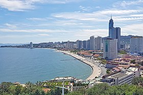
 View over Yantai, 2017 |
||
|
|
||
| Coordinates | 37 ° 24 ' N , 121 ° 16' E | |
 Location Yantais in Shandong |
||
| Basic data | ||
| Country | People's Republic of China | |
| region | East china | |
| province | Shandong | |
| ISO 3166-2 | CN-SD | |
| status | district-free city | |
| structure | five city districts, six independent cities | |
| surface | 13,747 km² | |
| Residents | 7,089,400 (2017) | |
| density | 515.7 Ew. / km² | |
| Post Code | 264000 | |
| Telephone code | +86 (0) 535 | |
| Time zone | UTC + 8 | |
| Website | www.yantai.gov.cn | |
| politics | ||
| mayor | Chen Fei ( 陈飞 ) | |
Yantai ( Chinese 煙臺 市 / 烟台 市 , Pinyin Yāntái Shì , rarely 煙台 市 , historically after Stange Tschifu - 芝罘 , outdated 之 罘 , short 煙 / 烟 , Yān ) is a district-free city in the east Chinese province of Shandong . It is Shandong's largest fishing port and an important economic center. The city is poetically known in Chinese as “Gǎngchéng” ( 港城 ), literally for “port city”. Yantai has an area of 13,746.5 km². At the end of 2017, 7,089,400 people lived there, 4,513,100 of them urban. 6,542,300 people were registered residents of Yantai, the rest were migrant workers, etc.
etymology
Yantai literally means "smoke terrace", "smoke platform", which comes from a watchtower with beacon ( 狼煙 墩台 / 狼烟 墩台 , short 煙台 / 烟台 ) from the 14th century, with which the approach of Wokou - ( pirates ) or enemy ships. This was on the mountain Yantai Shan ( 煙臺 山 / 烟台 山 , Yantái Shān - "signal tower mountain ", hist. 北山 - "north mountain"), a mountainous peninsula washed by the sea on three sides. Today there is a lighthouse here . The current name of the city comes from the Ming period from the 31st year of the reign ( 1398 ) in the Hongwu era (1368-1398) at the end of the reign of the first Ming emperor Zhū Yuánzhāng ( 朱元璋 ). The previously used German name "Tschifu", English Chefoo, Cheefoo, Chih-fou or Chi-fu ( 芝罘 , hist .: 之 罘 ), is actually just the name of the offshore island "Zhīfú Dǎo" ( 芝罘 島 / 芝罘 岛 , hist .: 之 罘 島 / 之 罘 岛 ) in the Zhifu district of the same name .
The historical name in the west "Tschifu", "Chefoo" etc. refers to the historical name in feudal China for today's area of Yantai. According to Shiji's records , the Emperor Qin Shihuangdi visited this place in the 28th year of his reign (219 BC) during his "Eastern Inspection of the Empire" ( 東 巡 / 东 巡 ) and climbed the mountain "Zhīfú Shan" (hist .: 之 罘 山 ) on today's island of the same name, Zhifu. From that time until the end of the Qing period , Chinese sources used the term "zhifu" for this historical area. Due to the historically early opening of the port city to trade with the West, the historical name was first found on the maps of western merchants and found its way into the Encyclopædia Britannica .
geography
Yantai is located on the Shandong Peninsula south of the Bohai Sea (a marginal sea of the Yellow Sea ), near the southern tip of Korea . The marine area of Yantai comprises 63 offshore islands. The coastline has a length of 909 kilometers. In the east lies the neighboring city of Weihai , in the west the city of Weifang and in the southwest Qingdao .
Topographically, Yantai consists of 36.62% mountainous land, 39.7% hilly land, 20.78% plains and 2.9% basins. The highest point is Mount Kunyu ( 崑嵛山 / 昆嵛山 ) at 922.8 meters .
The main rivers are:
- Dagu River ( 大沽河 )
- Dagujia River ( 大沽 夾河 / 大沽 夹河 )
- Huangshui River ( 黃 水河 / 黄 水河 )
- Jie River ( 崑嵛山 / 昆嵛山 )
- Wang River ( 王 河 )
- Wulong River ( 五 龍河 / 五 龙河 )
- Xin'an River ( 辛安 河 )
All administrative divisions of Yantai, with the exception of the independent city of Qixia , are located on the coast.
history
The region was inhabited by the Laiyi people in the Middle Ages . It is believed that they formed a small state around what is now Laizhou City during the Xia Dynasty .
In 1398 the beacon was built, which centuries later would give it its name.
In July 1858, the Chinese Empire signed the Treaty of Tianjin and Dengzhou , as the port city was previously called, and was renamed Yantai. Yantai opened its port in 1861. 17 nations, including Great Britain , set up representations in Yantai.
At the beginning of the 20th century, Yantai, like that of the southwest of the Shandong peninsula, was ruled by Germany from Kiautschou . The US Navy later maintained a base for its Asian fleet here . (See unequal contracts )
Administrative structure
| map |
|---|
Since the community reform on June 5, 2020, Yantai has consisted of five urban districts and six independent cities. These are:
- Fushan district (福山区), 706 km², approx. 340,000 inhabitants (2001);
- Laishan district (莱山区), 258 km², approx. 160,000 inhabitants (2001);
- Muping district (牟平 区), 1,589 km², approx. 480,000 inhabitants (2001);
- Zhifu district (芝罘区), 174 km², approx. 640,000 inhabitants (2001);
- Penglai district (蓬莱 区), 1,185 km², approx. 530,000 inhabitants (2001);
- City of Haiyang (海阳 市), 1,881.6 km², approx. 690,000 inhabitants (2001);
- City of Laiyang (莱阳 市), 1,732 km², approx. 890,000 inhabitants (2001);
- City of Laizhou (莱州 市), 1,878 km², approx. 870,000 inhabitants (2001);
- City of Longkou (龙口 市), 893 km², approx. 620,000 inhabitants (2001);
- City of Qixia (栖霞 市), 2,016 km², approx. 660,000 inhabitants (2001);
- City of Zhaoyuan (招远 市), 1,433 km², approx. 580,000 inhabitants (2001).
traffic
Yantai is the terminus of a railway line and a highway from Qingdao . There are regular shipping services to Dalian , Qinhuangdao and Tianjin . Yantai also has its own airport, Yantai Penglai International Airport , with connections to various major cities in China and international connections to, for example, Seoul , Osaka , and Hong Kong . It is 43 kilometers from the city center and opened on May 28, 2015.
economy
In the 1990s , Yantai City and District developed into a modern economic center.
- Gross domestic product : 561.387 billion renminbi (2013)
- GDP per capita: 80,357 renminbi (2013)
Yantai is a center of Chinese wine production and, along with the (also Chinese) autonomous region of Ningxia, is the only regional authority in the world with observer status in the International Organization for Vine and Wine .
Buildings
The tallest building in the city is the 323-meter-high Yantai Shimao No. 1 The Harbor .
Sons and Daughters of the City (selection)
- Andreas Koch (1871–1952), German lawyer and politician, member of the Hamburg citizenship and the Hamburg citizens' committee, councilor at the Hanseatic Higher Regional Court
- Chou Wen-chung (1923–2019), American composer of Chinese origin
- Zhang Wannian (1928–2015), General of the People's Liberation Army
- Chi Haotian (* 1929), General of the People's Liberation Army
- He Weifang (* 1960), law professor
- Wang Yaping (* 1980), military pilot and astronaut
- Liu Chunhong (* 1985), weightlifter
- Zhou Lulu (* 1988), weightlifter
Web links
- Official Website (Chinese)
- Historic photos of Yantai (English)
- Yantai 1912 - Area map, George Hure (English)
Individual evidence
- ↑ "Short biography Chen Fei - 陈飞 简历": (Chinese) [1] In: ldzl.people.com.cn, accessed on April 3, 2019 - online
- ↑ 烟台 概况. In: yantai.gov.cn. May 1, 2018, accessed April 30, 2020 (Chinese).
- ↑ 蓬莱 区 , 来 了! In: thepaper.cn. June 22, 2020, accessed July 2, 2020 (Chinese).
- ↑ "Flight connections at Yantai Penglai International Airport 2018 - 烟台 蓬莱 国际 机场 - 烟台 国际 机场 2018 年 航線 網絡 分布 圖": (Chinese) [2] In: www.ytairport.com.cn, accessed on April 3, 2019 - online
- ↑ "Yantai Penglai International Airport - Milestones of Development - 烟台 蓬莱 国际 机场 - 发展 历程": (Chinese) [3] In: www.ytairport.com.cn, accessed on April 3, 2019 - online
- ↑ "Annual Statistical Report Shangdong - 山东 统计 年鉴": (Chinese, English) [4] In: www.stats-sd.gov.cn, accessed on April 3, 2019 - online


