
Hirschfeld (Leipzig)


The place Hirschfeld is a district of Leipzig . He came through the incorporation of angels village to which he previously belonged to Leipzig and now stands in the administrative division of Leipzig along with Althen and Kleinpösna the district Althen-Kleinpösna .
Location and local characteristics
| Population development | |
| year | Residents |
| 1552 | 17 yards |
| 1764 | 14 yards |
| 1834 | 135 |
| 1871 | 143 |
| 1910 | 137 |
| 1925 | 148 |
| 1939 | 137 |
| 1946 | 237 |
| 1950 | 218 |
| 1964 | 139 |
| 1996 | 96 |
| 2001 | 116 |
Hirschfeld is located in the east of Leipzig about 11 kilometers from Leipzig city center. The surrounding towns are Althen, Borsdorf , Zweenfurth , Wolfshain, Albrechtshain , Kleinpösna, Baalsdorf and Engelsdorf, clockwise from the north .
The place consists of a single street that runs from southwest to northeast and on both sides of which the properties are located. Immediately at the southwest exit of the village is the Kleinpösna driveway of the A14 motorway . Hirschfeld has an hourly bus connection to the city center via line 73 of the LVB .
Hirschfeld is located in the middle of fields, touched by the lake area of a gravel quarry in the east, and has retained its village character. It is one of the few places without new settlements built after 1990, which is also reflected in its almost constant population of just over 100 for centuries, apart from the increase due to refugees and displaced persons after 1945. There are no public facilities in the village.
history
Hirschfeld was created in the 12th century in the course of the German settlement in the east as a street green village . It was first mentioned in writing in 1335 in a tax register as Herswelt . In 1350 it was called Hersvelde , and the only street in town, Hersvelder Straße, still reminds of this today.
From the second half of the 14th century Hirschfeld was owned by the Georgen nunnery in Leipzig . With the dissolution of the monastery during the Reformation , the village fell to the City Council of Leipzig in 1543. He sold it to Johann Ponickau on Gut Pomßen in 1641 to settle debts . Within the Ponickau family, Hirschfeld came under the rule of the Belgershain estate through purchase in 1729 . With changing owners of Belgershain it stayed that way until a local council was formed in Hirschfeld on the basis of the Saxon rural community order of 1838 . Until 1856, Hirschfeld was part of the Electoral Saxon or Royal Saxon District Office in Leipzig . In 1856 jurisdiction was transferred to the Leipzig I Court Office . From 1875 the place belonged to the administrative authority of Leipzig .
In the Battle of the Nations , Hirschfeld was spared combat operations, but suffered from billeting. In the First World War fell ten men of Hirschfeld, in World War II, eight.
The connection to the electrical power supply network took place in 1911, the water pipe connection only in 1982/83 after a flood that contaminated the wells, and the sewage connection in 1992. The work on the motorway construction that began in 1938/39 was interrupted during the Second World War and only on the section near Hirschfeld Finished in 1970. In the 1950s, the collectivization of agriculture also began in Hirschfeld , initially with the formation of an LPG type I. Increasingly larger units were created with the neighboring villages, until the state-owned Gut Engelsdorf finally took over the plant production of the entire area at the end of the 1970s local LPG only animal production remained. That is why barns were also rented out as warehouses. After the fall of the Wall , a large private company in Althen took over large parts of the Hirschfelder Flur. For example, private handicraft businesses set up shop in some Hirschfelder Höfe. In 1993 gravel mining began east of Hirschfeld , which was intensified from 1996, creating large open water areas.
On October 1, 1975, Hirschfeld merged with the Kleinpösna community. On January 1, 1994 it was incorporated into Engelsdorf and on January 1, 1999 with this to Leipzig.

church
As building findings show, the Hirschfeld Church was built as a Romanesque choir tower church when the place was founded . From around 1500 it was a subsidiary church of Engelsdorf. In 1721/1722 it was fundamentally rebuilt in line with a Protestant, simple, baroque conception of art. In 1955/1956 the interior of the church was renewed, with the Leipzig sculptor Max Alfred Brumme redesigning the altar, pulpit, lighting and coloring. The Romanesque baptismal font from the 13th century, which was moved to the cemetery during the Baroque era, was revised and brought back into the church. Further renovations followed in 1992 (outside) and 2002 (inside).
school
From around 1580 the Hirschfeld children went to school in Engelsdorf to see the sexton. In 1738 a catechist began to teach the Hirschfeld children in turn in the courtyards, later in the parish hall, and from 1814 back in the courtyards. From 1815 there was a teaching position. The teacher lived in a room in which he also taught, and in 1857 a second was added as a classroom. In 1887 a new school building was built. From 1925 to 1952 the Hirschfeld children attended school in Kleinpösna, then the one in Engelsdorf, where they were initially taken in winter in a horse-drawn carriage and from 1956 on a bus.
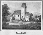
Church around 1840

Hirschfeld Church 2008

Former school building in front of the church

Hirschfelder farmhouse


literature
- Hirschfeld - A Historical and Urban Study . PRO LEIPZIG 2002
- Horst Riedel: Stadtlexikon Leipzig from A to Z . PRO LEIPZIG, Leipzig 2005, ISBN 3-936508-03-8 , pp. 239/240
- Cornelius Gurlitt : Hirschfeld. In: Descriptive representation of the older architectural and art monuments of the Kingdom of Saxony. 16. Issue: Amtshauptmannschaft Leipzig (Leipzig Land) . CC Meinhold, Dresden 1894, p. 54.
- Hirschfeld . In: August Schumann : Complete State, Post and Newspaper Lexicon of Saxony. 4th volume. Schumann, Zwickau 1817, p. 92.
Web links
- Hirschfeld in the Digital Historical Directory of Saxony
- Information website My district of the city of Leipzig for Althen-Kleinpösna
Individual evidence
- ↑ Digital Historical Directory of Saxony , accessed on August 27, 2012
- ↑ a b Hirschfeld - A historical and urban study . PRO LEIPZIG 2002
- ^ Karlheinz Blaschke , Uwe Ulrich Jäschke : Kursächsischer Ämteratlas. Leipzig 2009, ISBN 978-3-937386-14-0 ; P. 60 f.
- ↑ The Amtshauptmannschaft Leipzig in the municipal register 1900
Coordinates: 51 ° 20 ' N , 12 ° 32' E
Abtnaundorf | Althen | Anger | Baalsdorf | Böhlitz | Bösdorf | Breitenfeld | Burghausen | Cleuden | Connewitz | Crottendorf | Dölitz | Doze | Ehrenberg | Engelsdorf | Eutritzsch | Flickers | Göbschelwitz | Gohlis | Gottscheina | Großzschocher | Grünau | Gundorf | Hänichen | Hartmannsdorf | Serenity | Hirschfeld | Hohenheida | Holzhausen | Kleinpösna | Kleinzschocher | Knauthain | Knautkleeberg | Knautnaundorf | Lausen | Leutzsch | Liebertwolkwitz | Lindenau | Lindenthal | Loessnig | Lützschena | Marienbrunn | Meusdorf | Miltitz | Mockau | Möckern | Mölkau | Fog | Neuschönefeld | Neustadt | Neutzsch | Paunsdorf | Plagwitz | Funny | Plop | Portitz | Probstheida | Quasnitz | Rehbach | Reudnitz | Rückmarsdorf | Schleussig | Schönau | Schönefeld | Seehausen | Sellerhausen | Sommerfeld | Stamen | Stötteritz | Stünz | Südvorstadt | Thekla | Thonberg | Volkmarsdorf | True | Wiederitzsch | Windorf | Zuckelhausen | Zweinaundorf