
Crane requests
| Kranebitten ( settlement ) | |||
|---|---|---|---|
|
|||
| Basic data | |||
| Pole. District , state | Innsbruck city (I), Tyrol | ||
| Judicial district | Innsbruck (city) | ||
| Pole. local community | Innsbruck ( KG Hötting ) | ||
| Locality | Hötting | ||
| Statistical district | Hötting West | ||
| Coordinates | 47 ° 15 ′ 45 " N , 11 ° 19 ′ 42" E | ||
| height | 601 m above sea level A. | ||
| Residents of the stat. An H. | 1515 (2014) | ||
| Building status | 325 (2014) | ||
| surface | 6.59 km² | ||
| Post Code | 6020 Innsbruck | ||
| prefix | + 43/0512 (Innsbruck) | ||
| Statistical identification | |||
| Counting district / district | Hötting-West (70101 36) | ||
 Crane requests from the other side of the valley (the airport in front , the Inn on the left , the Mittenwaldbahn in the back , the Lohbachsiedlung in front on the right ) |
|||
| Source: STAT : index of places ; BEV : GEONAM ; TIRIS ; City of Innsbruck | |||

Kranebitten is a place in the Inn valley and part of the municipality of Innsbruck .
geography
Kranebitten is located five kilometers west of the city center , on the left bank of the Inn , at the foot of the northern chain at altitudes around 600 750 m above sea level. A. The small and large Solstein (2637 and 2541 m above sea level ) stand above crane requests, up the Martinswand .
Kranebitten and the houses uphill, around the Kranebitten stop of the Mittenwaldbahn and on Klammstrasse , form the statistical district of Hötting-West and belong to the district of Hötting West . The statistical district has an area of 659.1 ha and 1515 inhabitants (as of April 2014). To the west of the village is the Standschützen barracks in Innsbruck.
Neighboring places:
| Zirl (gem.) |
.svg)
|
Allerheiligen (Hötting) Lohbachsiedlung (Hötting) |
| Völs (Gem.) | Airport (Hötting) |
History, infrastructure and sights
Kranebitten already existed in the 14th century, in 1402 it was first mentioned as Krembittach . The name is derived from Kranawitt ( ahd. Chranawittu ), a common expression for juniper in the Bavarian language area . After the creation of the local communities in 1849/50, Kranebitten belonged to the community of Hötting and was incorporated into Innsbruck in 1938. Today, Kranebitten is still somewhat independent outside of the Innsbruck settlement unit and still has a certain village character, even though there are already multi-storey buildings here. Especially since the construction of the Mittenwaldbahn stop above the village in 1910–1912, construction activity began there too. In 1947 the airport Kranebitten was built on the Ulfiswiese on the Inn. The barracks , named after the Imperial and Royal Standschützen , was built in 1982–1985 and is now a garrison of the staff battalion of the 6th Jäger Brigade , the mountain brigade of the Austrian Armed Forces .
The Innsbruck campsite is of major tourist and economic importance today . Nevertheless, the place is increasingly suffering from structural weakness and tries to emancipate itself within Hötting West.
The entire area north of the town, including Kranebitter gorge and Martin Wall , part of the conservation area Martin Wall Solstein-Reitherspitze ; ( LSG 29/1989 ), and thus to the nature park and European protected area Alpenpark Karwendel ( AT3304000 , FFH and bird protection ). The Kranebitter Innau is also - particularly strictly - protected ; ( SSG 44/2005 ), which together with the Völser Innau forms the last remnant of the Innauen around Innsbruck.

Wegkapelle Kranebitter Allee
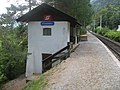
Kranebitten stop, a listed building

Mittenwaldbahn - Klammbach Bridge
.JPG)


The Martinswand reception building in the Hofwald west of the village and several other bridges are also listed.
- Historical maps

Kranebitten with the old Sill estuary, Tiergarten Island, to the city of Innsbruck
(approx. 1700, excerpt from Insprug with the area on 2 hours )
Innsbruck West
(around 1888, from the Innsbruck area , Meyers Konversationslexikon , 4th edition )
Hötting, Innsbruck West
(around 1898–1905, detail from Franzisco-Josephinische Landesaufnahme, sheet 29–47 Innsbruck )
.png)


literature
- Franz-Heinz Hye , Innsbruck City Archives (ed.): Hötting-West / Allerheiligen. Volume 3 of The Districts of Innsbruck , Innsbruck 1987.
- Klaus Lugger, Claudia Wedekind: Social housing: Innsbruck from 1900 to today. Verlag Haymon, 1993, ISBN 978-3-85218-135-6 (385-218135-6).
Web links
Individual evidence
- 70101 - Innsbruck. Community data, Statistics Austria .
- www.geschichte-tirol.com: Hötting
- ↑ See spatial reference system , Statistics and Reporting Unit, innsbruck.gv.at → Office | Administration → Statistics | Figures ; in particular the documents given there: spatial reference system and plan presentation of the cadastral communities , the statistical city districts and the statistical districts
- ↑ City of Innsbruck: area, inhabitants and number of buildings of the individual census districts and statistical districts of the city of Innsbruck (as of April 2014) (PDF; 143 kB)
- ^ Otto Stolz: History of the City of Innsbruck . Tyrolia-Verlag, 1959, p. 435
- ↑ Peter Anreiter: A name-based foray through Innsbruck (and the surrounding area) . In: Almud Magis, Bernhard Nicolussi Castellan (ed.): Matters of opinion. 61 reasons to leave Innsbruck or stay there. Michael-Gaismair-Gesellschaft, Innsbruck 1996, ISBN 3-900601-08-9 , pp. 179-183
- ^ Staff battalion 6 , bundesheer.at
-
↑ Infrastructure in Kranebitten is being thinned out even further . In: Bezirksblätter , mein district.at > Tirol> Innsbruck ;
Roland Müller: Our diverse city . In: Westwind - The district newspaper of Hötting-West and Kranebitten, March 29, 2010. - ↑ Martinswand - Solstein - Reither Spitze , tiroler-schutzgebiete.at
- ↑ Standard Data Form ( page no longer available , search in web archives ), NATURA 2000 Site code: AT3304000, tirol.gv.at (pdf; 106 kB)
- ↑ Kranebitter Chapel. Parish Kranebitten, on dibk.at.

Cadastral communities, localities and districts: Amras | Arzl | Hötting | Igls | Innsbruck | Mühlau | Pradl | Vill | Wilten
Statistical districts: city center | Mariahilf-St. Nicholas | Dreiheiligen slaughterhouse | Saggen | Wilten | Sieglanger-Mentlberg | Pradl | Reichenau | Hötting | Höttinger Au | Hötting West | Hungerburg | Mühlau | Industrial area Mühlau / Arzl | Arzl | Olympic Village | Amras | Commercial area Roßau | Vill | Igls
City districts (settlement identification) :
Amras •
Arzl •
Hötting •
Innsbruck •
Mühlau •
Olympic village •
Pradl •
Wilten
villages:
Igls •
Vill |
Rotten:
Finkenberg •
Untere Figge |
Settlements:
Allerheiligenhöfe •
Egerdach •
Hungerburg-Hötting •
Hungerburg-Mühlau •
Kranebitten •
Mentlbergsiedlung •
Sieglanger •
Sadrach |
Groups of houses:
Alpenzoo •
Mount of Olives |
Other locations:
Ambras Castle •
Arzler Alm •
Innsbruck Airport •
Gluirschhöfe •
Grillhof •
Gramartboden •
Hafelekar mountain station •
Handlhof •
Harterhof •
Holy Year settlement •
Heiligwasser •
Hohenburg Castle •
Hörtnagl settlement •
Höttinger Alm •
Höttinger Bild •
Lohbach settlement •
Mariahilf •
Mentlberg Castle •
Mentlbergsiedlung •
Möslalm •
Neuarzl •
Peerhofsiedlung •
Pfeishütte •
Planötzenhof •
Roßau •
St. Nikolaus •
Seegrube station •
Taxburg Castle •
Tivoli •
Zenzenhof
Counting districts: Old Town | Left bank of the Inn | Inner City North | Inner City-West | Inner City East | Holy Trinity | Saggen-West | Saggen-North | Saggen-East | Wilten-Ost | Wilten-Mitte | Wilten-South | Wilten-West | Sieglanger | Mentlberg | Pradl-North | Pradl-Mitte-West | Pradl-Middle-East | Pradl-South | Pradl-East | Reichenau-West | Reichenau-East | Hötting center | Hungerburg-Hötting | Höttinger Au-Ost | Höttinger Au-West | Lohbach settlement | Hörtnaglsiedlung | Hötting-West | Mühlau village | Hungerburg-Mühlau | Mühlau-Ost | Mühlau shooting range | Amras-South | Amras-West | Amras North | Arzl-Dorf | Arzl-West | Arzl-South | Arzl Olympic Village | Vill | Igls