Jedwabno
| Jedwabno | ||
|---|---|---|

|
|
|
| Basic data | ||
| State : | Poland | |
| Voivodeship : | Warmia-Masuria | |
| Powiat : | Szczytno | |
| Geographic location : | 53 ° 32 ' N , 20 ° 44' E | |
| Residents : | 1271 (2011) | |
| Postal code : | 12-122 | |
| Telephone code : | (+48) 89 | |
| License plate : | NSZ | |
| Economy and Transport | ||
| Street : | DK 58 : Olsztynek ↔ Szczytno - Pisz - Szczuczyn | |
| Ext. 508 : Wielbark - Rekownica → Jedwabno | ||
| Ext. 545 : Działdowo - Nidzica - Zimna Woda → Jedwabno | ||
| Rail route : | no rail connection | |
| Next international airport : | Danzig | |
| Olsztyn-Mazury | ||
| Gmina | ||
| Gminatype: | Rural community | |
| Gmina structure: | 25 localities | |
| 17 school authorities | ||
| Surface: | 311.51 km² | |
| Residents: | 3653 (Jun. 30, 2019) |
|
| Population density : | 12 inhabitants / km² | |
| Community number ( GUS ): | 2817032 | |
| Administration (as of 2007) | ||
| Community leader : | Włodzimierz Budny | |
| Address: | ul.Warmińska 2 12-122 Jedwabno |
|
| Website : | www.jedwabno.pl | |
Jedwabno [ jɛd'vabnɔ ] ( German Jedwabno , 1938–1945 Gedwangen ) is a village and the seat of a rural community of the same name in the Powiat Szczycieński ( Ortelsburg district ) in the Polish Warmian-Masurian Voivodeship .
Geographical location
The place is located in the historical region of East Prussia , on the southern edge of the Allenstein Lake District, between the Hartig and Narth lakes, about 20 kilometers southwest of Szczytno ( Ortelsburg in German ). Numerous elevations with heights of 150 meters make the landscape hilly, which is covered to the west with the former Hartigwald.
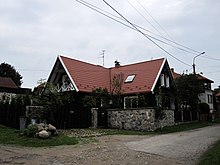
Jedwabno Village (Gedwangen)
history
Place name
The place name is said to be derived from the Prussian gedewewe or geduwene ( German barley ).
Local history
In the first quarter of the 14th century, the Teutonic Order began to settle the then so-called Sassenland east of the Vistula . At that time the area was covered with jungle and almost uninhabited. The development of the area was from west to east and was essentially completed in 1325. Since, according to unconfirmed sources, the religious festivals on the castle hill north of what will later become Jedwabno were built around 1375 and only mentioned in documents in 1397, it can be assumed that the place was founded relatively late. In contrast to the castles built earlier in the region, the building of the order hardly had a defensive character, rather it is referred to as a so-called hunting lodge.
At the time of the Teutonic Order , the Osterode Order Commandery included the Jedewewe district , from which the villages Jedwabno and Willenberg later emerged. In 1436 a settlement called Gedwangen is mentioned for the first time in the tax registers of the Osterode Commandery . The first church in the village was built before 1400. The tax register of 1436 shows that the inhabitants of the place lived mainly from forest beekeeping. In addition, the nearby lime was also burned, which is known to have been used to build the Neidenburg as early as 1383 , but which was also sold as far as Königsberg and Elbing. After the secularization of the religious order to the Duchy of Prussia in 1525, the clerical committees were transformed into secular circles, Jedwabno came under the administration of the Oberland district with Saalfeld as its center. After an administrative reform, the Oberländische Kreis was dissolved in 1752, and Jedwabno was now subordinated to the newly created Neidenburg district .
In 1785 Jedwabno is referred to as a royal Beutnerdorf (beekeeping village) with 57 fireplaces (households). At the end of the 18th century there were 57 houses in Jedwabno. The place had the character of a market settlement, favored by its location on a busy trade route. However, since the modern traffic routes built in the 19th century did not touch Jedwabno, the structure changed little until the 20th century. In 1874 the Jedwabno District was established. Most of the villagers were Protestant.
Due to the provisions of the Versailles Treaty , the population in the Allenstein voting area , to which Jedwabno belonged, voted on July 11, 1920 on whether they would continue to belong to East Prussia (and thus to Germany) or join Poland. In Jedwabno, 606 residents voted to remain with East Prussia, while Poland did not vote.
Between 1910 and 1939 the population rose from 915 to 1,288. On July 16, 1938, the place name was changed to Gedwangen .
Until 1945 Gedwangen belonged to the district Neidenburg in the administrative district of Olsztyn the Prussian province of East Prussia .
Towards the end of the Second World War , the region was conquered by the Red Army in January 1945 . Gedwangen was also affected during the fighting, so the Protestant church was badly damaged. After the end of the war, Gedwangen and the southern half of East Prussia were placed under Polish administration. After that, the immigration of Polish civilians began. The village was renamed Jedwabno again. Where German locals had not fled, they were in the period that followed sold .
Jedwabno / Gedwangen District (1874–1945)
The Jedwabno District, established on May 28, 1874 (renamed "Gedwangen District" on November 15, 1938) belonged to the East Prussian Neidenburg District and initially comprised seven villages:
| German name | Changed name from 1938 to 1945 |
Polish name | Remarks |
|---|---|---|---|
| Jedwabno | Squeezed | Jedwabno | |
| Lip nod | Lipniki | 1928 incorporated into Jedwabno | |
| Narthen | Narty | ||
| New Borowen | Bush forest | Nowe Borowe | |
| Rubble | Szuć | ||
| Schuttschenofen | Piduń | ||
| Warchallen | Warchały |
On January 1, 1945, six other places formed the district: Buschwalde, Gedwangen, Narthen, Schutschen, Schuttschenofen and Warchallen.
Population development
| year | Residents | Remarks |
|---|---|---|
| 1816 | 246 | |
| 1852 | 498 | |
| 1858 | 541 | including 526 Evangelicals, six Catholics and nine Jews |
| 1905 | 772 | |
| 1933 | 1,207 | |
| 1939 | 1,288 | |
| 2011 | 1,271 |
church
Evangelical
Parish
A church already existed in Jedwabno in the pre-Reformation period. She took over the Reformation and became Protestant . The church in Malga (Polish : Małga ) was assigned as a branch church until 1889 . The king - later the state authorities - exercised patronage over the church of Jedwabno. Until 1945 Jedwabno was incorporated into the church district Neidenburg (Polish Nidzica ) in the church province of East Prussia of the Church of the Old Prussian Union . Today the parish belongs to the parish in Pasym (Passenheim) in the diocese of Masuria of the Evangelical-Augsburg Church in Poland .
Church building
The village church was destroyed in a fire in 1721. It was not until 1757 that the construction of the church, which still exists today, began, which took two years. For a long time the hunting lodge of the order was used as a rectory. This too had to be replaced by a new building in 1827 because of its dilapidation. A manor-like building was created in the classical style. The church was badly damaged in World War II . In 1966 the last remnant was torn down in the form of a leaning tower.
Roman Catholic
In 1928 and 1929 the Catholic community built a new church dedicated to St. Joseph and Our Lady of Czestochowa.
school
There was a school in Jedwabno since 1595. For a long time she was the only one in the parish. It was single-class until a new school building was built in 1859, then two-class until 1897, then three-class. In 1926 the village received a new elementary school with a sports field, which then had four classes.
Personalities
The doctor Ottmar Kohler practiced in Jedwabno. He is the father of the surgeon of the same name, Ottmar Kohler (1908–1979), who served the writer Heinz-Günther Konsalik as a model for his book The Doctor of Stalingrad . The father died while his wife was pregnant and was buried in the Jedwabno cemetery. After the husband's death, the mother moved to Gummersbach , where the son was born.
Gmina Jedwabno
Community area
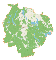
The rural community Jedwabno is one of eight communities in the powiat Szczycieński ( Ortelsburg district ). With an area of 311.51 km² it makes up 16.11% of the total area of the powiat. 20% of the community area is used as arable land, 63% is forest.
Neighboring communities
Gmina Jedwabno is surrounded by seven neighboring municipalities, all of which are within the Warmian-Masurian Voivodeship :
-
Powiat Szczycieński ( Ortelsburg District ):
- City and rural communities Pasym (Passenheim) and Wielbark (Willenberg) and the rural community Szczytno (Ortelsburg)
- Powiat Nidzicki ( Neidenburg district ):
- Powiat Olsztyński ( Olsztyn County ) :
Residents
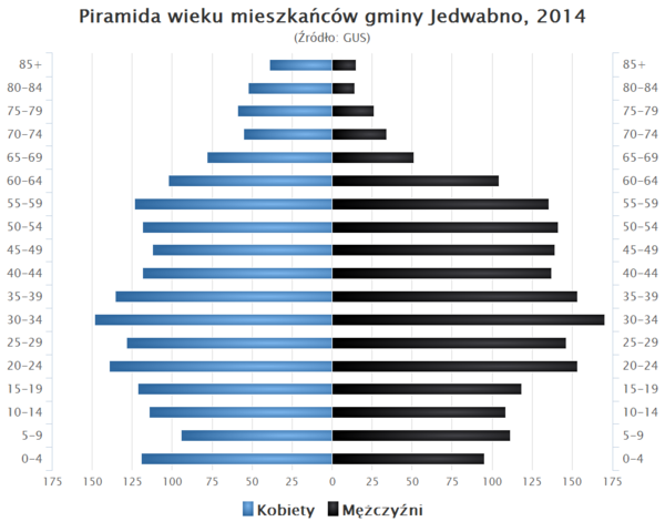
On June 30, 2019, Gmina Jedwabno had 3,653 inhabitants. About a third of them live in the central village of Jedwabno. A table from 2014 illustrates the age structure of the municipality:

Community structure
The following localities belong to the rural community of Jedwabno:
| Polish name | German name (until 1945) |
|---|---|
| * Brajniki | Bray nod |
| * Burdąg | Burdungen |
| * Czarny Piec | Black oven |
| Dębowiec | Dembowitz 1935–45 Eichenau |
| * Dłużek | Dluszek 1932–45 Hartwigswalde |
| Dzierzki | Dziersken 1936–45 old ovens |
| Grobka | Grobka 1938–45 Mittenwald |
| * Jedwabno | Jedwabno 1938–45 Gedwangen |
| * Feces | Omulefofen |
| * Lipniki | Lip nod |
| * Małszewo | Malschöwen 1938–45 Malshöfen |
| * Narty | Narthen |
| * Nowe Borowe | New Borowen 1938–45 Buschwalde |
| * Nowy Dwór | Neuhof |
| Nowy Las | Neuwald |
| Omulew | Omulef |
| * Piduń | Schuttschenofen |
| Rekowe | Rekowen 1938–45 Reckau |
| * Rekownica | Rekownitza 1921–45 Großwalde |
| Strzała | |
| * Szuć | Rubble |
| * Waplewo | Waplitz |
| Warchały | Warchallen |
| * Witówko | Ittowken 1938–45 Ittau |
| * Witowo | Ittowen 1927–45 Gittau |
Małga (German Malga ) is a place that has not existed since 1954. In its place there is now a nature reserve ("Rezerwat przyrody Małga"). As a submerged place is also: Przysowy (German Omulefmühle ).
Web links
- Jedwabno website (Polish)
- Website about Jedwabno (Polish)
Individual evidence
- ↑ a b Wieś Jedwabno w liczbach (Polish)
- ↑ Polish Postal Code Directory 2013 (Polish)
- ↑ a b Urząd Gminy Jedwabno: Sołectwa
- ↑ population. Size and Structure by Territorial Division. As of June 30, 2019. Główny Urząd Statystyczny (GUS) (PDF files; 0.99 MiB), accessed December 24, 2019 .
- ↑ a b c d Jedwabno - Gedwangen at ostpreussen.net
- ^ Max Toeppen : History of Masuria. A contribution to the Prussian state and cultural history . Danzug 1870, p. 66.
- ^ A b Johann Friedrich Goldbeck : Complete topography of the Kingdom of Prussia . Part I: Topography of East Prussia , Königsberg / Leipzig 1785, p. 72.
- ^ Official Journal of the Royal Government of Königsberg , No. 21, Königsberg i. Pr., May 21, 1874, p. 161, paragraph 3.
- ↑ Herbert Marzian , Csaba Kenez : "Self-determination for East Germany - A Documentation on the 50th Anniversary of the East and West Prussian Referendum on July 11, 1920"; Editor: Göttinger Arbeitskreis , 1970, p. 89
- ^ Rolf Jehke, Jedwabno / Gedwangen district
- ↑ Alexander August Mützell and Leopold Krug : New topographical-statistical-geographical dictionary of the Prussian state . Volume 2: G – Ko , Halle 1821, p. 249.
- ^ Kraatz: Topographisch-Statistisches Handbuch des Prussisches Staats . Berlin 1856, p. 261.
- ↑ Adolf Schlott : Topographical-statistical overview of the government district of Königsberg . Hartung, Königsberg 1861, p. 176, item 62.
- ↑ http://wiki-de.genealogy.net/Jedwabno
- ^ A b Michael Rademacher: German administrative history from the unification of the empire in 1871 to the reunification in 1990. neidenburg.html # ew33ndnbgedwangen. (Online material for the dissertation, Osnabrück 2006).
- ↑ Kobiety = women, Mężczyźni = men
- ↑ The * indicates a Schulzenamt (Polish Sołectwo ) for the 2019-2024 term of office


