
Le Wast
| Le Wast | ||
|---|---|---|

|
|
|
| region | Hauts-de-France | |
| Department | Pas-de-Calais | |
| Arrondissement | Boulogne-sur-Mer | |
| Canton | Desvres | |
| Community association | Desvres-Samer | |
| Coordinates | 50 ° 45 ′ N , 1 ° 48 ′ E | |
| height | 42-70 m | |
| surface | 0.9 km 2 | |
| Residents | 206 (January 1, 2017) | |
| Population density | 229 inhabitants / km 2 | |
| Post Code | 62142 | |
| INSEE code | 62880 | |

Le Wast is a French municipality with 206 inhabitants (as of January 1 2017) in the department of Pas-de-Calais in the region of Hauts-de-France (before 2016 Nord-Pas-de-Calais ). It belongs to the arrondissement of Boulogne-sur-Mer and the canton of Desvres .
geography
Le Wast is located about 13 kilometers east-northeast of Boulogne-sur-Mer . The municipality is part of the Caps et Marais d'Opale Regional Nature Park . The park administration is also located here.
Le Wast is surrounded by the neighboring communities of Colembert in the north and east, Alincthun in the south and Bellebrune in the south and west.
Population development
| year | 1962 | 1968 | 1975 | 1982 | 1990 | 1999 | 2006 | 2013 |
| Residents | 216 | 200 | 195 | 171 | 185 | 180 | 194 | 203 |
| Source: Cassini and INSEE | ||||||||
Attractions
- Saint-Michel church from the 11th century, historique monument since 1913
- Le Huisbois mansion from 1755

Saint-Michel church
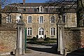
Manor house of Le Huisbois


Web links
Commons : Le Wast - collection of images, videos and audio files