
Condette
| Condette | ||
|---|---|---|

|
|
|
| region | Hauts-de-France | |
| Department | Pas-de-Calais | |
| Arrondissement | Boulogne-sur-Mer | |
| Canton | Outreau | |
| Community association | Boulonnais | |
| Coordinates | 50 ° 39 ′ N , 1 ° 38 ′ E | |
| height | 6-106 m | |
| surface | 16.26 km 2 | |
| Residents | 2,506 (January 1, 2017) | |
| Population density | 154 inhabitants / km 2 | |
| Post Code | 62360 | |
| INSEE code | 62235 | |
| Website | http://www.condette.fr/ | |
 Condette Town Hall |
||

Condette is a French commune with 2,506 inhabitants (as of January 1 2017) in the department of Pas-de-Calais in the region of Hauts-de-France . It belongs to the arrondissement of Boulogne-sur-Mer and the canton of Outreau (until 2015: canton of Samer ). The inhabitants are called Condettois .
geography
Condette is located near the Atlantic coast (about five kilometers), which is called the Opal Coast here . The municipality is part of the Caps et Marais d'Opale Regional Nature Park .
Condette is surrounded by the neighboring communities of Saint-Étienne-au-Mont in the north and west, Isques in the northeast, Hesdin-l'Abbé and Hesdigneul-lès-Boulogne in the east, Verlincthun in the southeast, Nesles in the south and Neufchâtel-Hardelot in the west and Southwest.
The A16 autoroute runs through the municipality .
Population development
| year | 1962 | 1968 | 1975 | 1982 | 1990 | 1999 | 2006 | 2012 |
| Residents | 1,420 | 1.611 | 1,869 | 2,084 | 2,392 | 2,675 | 2,596 | 2,574 |
From 1962 only residents with primary residence
Attractions
- Saint-Martin church from the 15th century
- Hardelot Castle from the 13th century, Monument historique
- Villa Les Tourelles, Monument historique
- Grand Moulin mansion, monument historique since 1998

Saint Martin Church
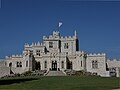
Hardelot Castle

Villa Les Tourelles


Parish partnership
There is a partnership with the German municipality of Nauort in Rhineland-Palatinate .