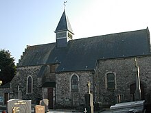
Saint-Inglevert
| Saint-Inglevert | ||
|---|---|---|

|
|
|
| region | Hauts-de-France | |
| Department | Pas-de-Calais | |
| Arrondissement | Boulogne-sur-Mer | |
| Canton | Desvres | |
| Community association | Terre des Deux Caps | |
| Coordinates | 50 ° 53 ′ N , 1 ° 45 ′ E | |
| height | 85-163 m | |
| surface | 6.6 km 2 | |
| Residents | 783 (January 1, 2017) | |
| Population density | 119 inhabitants / km 2 | |
| Post Code | 62250 | |
| INSEE code | 62751 | |
Saint-Inglevert ( Flemish : Santingeveld ) is a commune in the Pas-de-Calais department in the Hauts-de-France region .
location
Saint-Inglevert is about 19 kilometers north of Boulogne-sur-Mer , at the junction of the D244 and the A16 motorway . The municipality is located a few kilometers from the English Channel and is part of the Caps et Marais d'Opale Regional Nature Park .
history
During the Battle of Britain between Saint-Inglevert and Pihen-lès-Guînes an important field airfield of the German Air Force was located .
population
| 1962 | 1968 | 1975 | 1982 | 1990 | 1999 | 2006 |
|---|---|---|---|---|---|---|
| 405 | 433 | 450 | 420 | 502 | 539 | 683 |
| Population census started in 1962 with no duplicate listings | ||||||
Attractions
- Church of St.Barnabé from the sixteenth century
- Traces of an old abbey hospital
- Saint-Inglevert Airfield
Web links
Commons : Saint-Inglevert - collection of images, videos and audio files
Individual evidence
- ^ De Nederlanden in Frankrijk, Jozef van Overstraeten, 1969

