Le Portel
| Le Portel | ||
|---|---|---|

|
|
|
| region | Hauts-de-France | |
| Department | Pas-de-Calais | |
| Arrondissement | Boulogne-sur-Mer | |
| Canton | Boulogne-sur-Mer-2 | |
| Community association | Boulonnais | |
| Coordinates | 50 ° 42 ′ N , 1 ° 34 ′ E | |
| height | 0-59 m | |
| surface | 3.85 km 2 | |
| Residents | 9,240 (January 1, 2017) | |
| Population density | 2,400 inhabitants / km 2 | |
| Post Code | 62480 | |
| INSEE code | 62667 | |
| Website | http://www.ville-leportel.fr/ | |
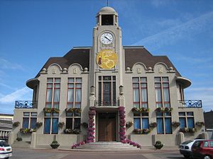
 Le Portel Town Hall |
||
Le Portel is a French municipality with 9240 inhabitants (as of January 1 2017) in the department of Pas-de-Calais in the region of Hauts-de-France . It belongs to the arrondissement of Boulogne-sur-Mer and the canton of Boulogne-sur-Mer-2 . The inhabitants are called Portelois .
geography
Le Portel is on the Opal Coast . Le Portel is surrounded by the neighboring communities of Boulogne-sur-Mer in the north, Outreau in the east and southeast, and Équihen-Plage in the south.
history
Before the community got its name as Le Portel (German: small harbor), it was known in the records (as in 858) as Turbodinghem (House of the Turbod).
Attractions
- Fort de l'Heurt fortress ruins (erected 1803–1805)
- Fort d'Alsprech
- Fort de Couppes
- Fort du Mur de l'Atlantique
Personalities
- Alfred Desenclos (1912–1971), composer and pianist
- Éric Dewilder (* 1964), football coach
- Lucien Leduc (1918–2004), football player and coach
- Rémy-Louis Leprêtre OFM (1878–1961), archbishop and diplomat
Community partnerships
Le Portel has partnerships with the following municipalities:
- Portel-des-Corbières , Aude department, France
- Stockelsdorf , Schleswig-Holstein, Germany
- Kawara , Burkina Faso
Web links
Commons : Le Portel - collection of images, videos and audio files

