Rinxent
| Rinxent | ||
|---|---|---|

|
|
|
| region | Hauts-de-France | |
| Department | Pas-de-Calais | |
| Arrondissement | Boulogne-sur-Mer | |
| Canton | Desvres | |
| Community association | Terre des Deux Caps | |
| Coordinates | 50 ° 48 ′ N , 1 ° 44 ′ E | |
| height | 7-90 m | |
| surface | 8.38 km 2 | |
| Residents | 3,001 (January 1, 2017) | |
| Population density | 358 inhabitants / km 2 | |
| Post Code | 62720 | |
| INSEE code | 62711 | |
| Website | http://www.ville-rinxent.fr/ | |
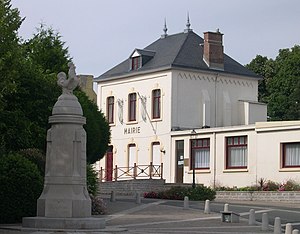
 Rinxent Town Hall |
||
Rinxent ( Dutch : Erningsem ) is a French municipality with 3001 inhabitants (as of January 1 2017) in the department of Pas-de-Calais in the region of Hauts-de-France . It belongs to the arrondissement of Boulogne-sur-Mer and is part of the canton of Desvres . The inhabitants are called Rinxentois .
geography
Rixent is on the Slack River . The municipality is part of the Caps et Marais d'Opale Regional Nature Park .
Rixent is surrounded by the neighboring communities of Ferques in the north, Rety in the east, Wierre-Effroy in the south and Marquise in the west.
Population development
| 1962 | 1968 | 1975 | 1982 | 1990 | 1999 | 2006 | 2012 |
|---|---|---|---|---|---|---|---|
| 3,267 | 3,340 | 3,195 | 3,094 | 2,860 | 2,797 | 2,772 | 2,771 |
Attractions
- Saint-Martin church, originally in the 15th / 16th centuries Built in the 19th century, rebuilt in the middle of the 19th century with today's cubage
- Saint-Maur church in the hamlet of Hydrequent from the 16th century, minor alterations at the end of the 19th century
- Remains of the old castle
- town hall
- The marble house (museum)
- Dombunker in the quarry of Hydrequent, used by the German army during World War II for the Krupp K5 (E) railway gun
Personalities
- Félix Goethals (1891–1962), racing cyclist
Web links
Commons : Rinxent - collection of images, videos and audio files

