
Missy VD
| VD is the abbreviation for the canton of Vaud in Switzerland and is used to avoid confusion with other entries of the name Missy . |
| Missy | |
|---|---|
 |
|
| State : |
|
| Canton : |
|
| District : | Broye-Vully |
| BFS no. : | 5821 |
| Postal code : | 1565 |
| Coordinates : | 564299 / 192 236 |
| Height : | 442 m above sea level M. |
| Height range : | 432–478 m above sea level M. |
| Area : | 3.11 km² |
| Residents: | 371 (December 31, 2018) |
| Population density : | 119 inhabitants per km² |
| Website: | www.missy.ch |
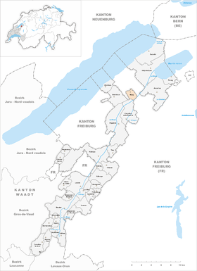
 Missy |
|
| Location of the municipality | |
  |
|
Missy is a municipality in the Broye-Vully district in the canton of Vaud in Switzerland . The former German name Missach (mentioned in 1446) is no longer used today.
geography
Missy is 442 m above sea level. M. , 7 km north-northeast of the district capital Payerne (air line). The former street row village extends slightly higher on the northern edge of the Broye plain, at the foot of the ridge between Lake Neuchâtel and the lower Broyetal , in the north-eastern Vaud Central Plateau .
The area of the 3.1 km² municipal area includes a section of the Broye plain. The communal soil extends from the canalised Broye northwards over the intensely agricultural plain, which is also crossed by the Petite Glâne , which is forced into a canal bed . To the north of the plain is the Molasse Ridge , which forms the southwestern continuation of Mont Vully . In the area of Missy, this height is divided by the valley of the Ruisseau des Vaux into the height of L'Ecrua in the west and Fochaux in the east. On the latter is 475 m above sea level. M. reached the highest point of Missy. In 1997, 10% of the municipal area was in settlements, 2% in forests and woodlands, 87% in agriculture and a little more than 1% was unproductive land.
The farm estate Les Pièces ( 439 m above sea level ) on the edge of the Broye plain belongs to Missy . The neighboring municipalities of Missy are Corcelles-près-Payerne in the canton of Vaud and Vallon , Saint-Aubin and Belmont-Broye in the canton of Friborg .
population
With 371 inhabitants (as of December 31, 2018) Missy is one of the small communities in the canton of Vaud. 86.6% of the residents are French-speaking, 10.9% German-speaking and 1.5% Portuguese-speaking (as of 2000). The population of Missy was 266 in 1860 and 359 in 1900. After the population had decreased to 252 by 1980, a slight increase has been registered since then.
economy
Missy was a predominantly agricultural village until the second half of the 20th century . Even today, arable farming (especially grain, sugar beet and vegetable crops) and fruit growing play an important role in the income structure of the population. Horse breeding also existed in the 18th century . Further jobs are available in local small businesses and in the service sector. In the last few decades the village has also developed into a residential community. Some workers are commuters who work mainly in Payerne.
traffic
The community has good transport connections. It is on the main road from Estavayer-le-Lac to Sugiez . The Avenches motorway junction on the A1 ( Lausanne - Bern ) is around 6 km from the town center. Missy is connected to the public transport network through the Postbus course, which runs from Estavayer-le-Lac to Freiburg .
history
The first written mention of the place took place in 1148 under the name Missiacum . Later the names Messi (1158), Missiaco (1183), Missye (1260) and Missie (1343) appeared. The place name goes back to the Roman surname Missius .
Since it was first mentioned, Missy belonged to the Cluniac priory of Payerne. The lords of Grandcour also owned rich estates in the municipality. With the conquest of Vaud by Bern in 1536, the village came under the administration of the Payerne governorate . After the collapse of the Ancien Régime , Missy belonged to the canton of Léman from 1798 to 1803 during the Helvetic Republic, which then became part of the canton of Vaud when the mediation constitution came into force . In 1798 it was assigned to the Payerne district.
Attractions
The current Missy Church was built in 1810. Some characteristic farmhouses from the 17th to 19th centuries have been preserved in the town center.
Web links
- Official website of the municipality of Missy (French)
- Gilbert Marion: Missy. In: Historical Lexicon of Switzerland .
- Aerial views of the village
Individual evidence
- ↑ Permanent and non-permanent resident population by year, canton, district, municipality, population type and gender (permanent resident population). In: bfs. admin.ch . Federal Statistical Office (FSO), August 31, 2019, accessed on December 22, 2019 .
Avenches | Bussy-sur-Moudon | Champtauroz | Chavannes-sur-Moudon | Chevroux | Corcelles-le-Jorat | Corcelles-près-Payerne | Cudrefin | Curtilles | Dompierre | Faoug | Grandcour | Henniez | Hermenches | Lovatens | Lucens | Missy | Moudon | Payerne | Prévonloup | Ropraz | Rossenges | Syens | Trey | Treytorrens (Payerne) | Valbroye | Villars-le-Comte | Villarzel | Vucherens | Vulliens | Vully-les-Lacs
Former parishes: Bellerive | Brenles | Carrouge | Cerniaz | Chabrey | Champmartin | Chesalles-sur-Moudon | Combremont-le-Grand | Combremont-le-Petit | Constantine | Cremin | Forel-sur-Lucens | Donatyre | Granges-près-Marnand | Marnand | Montmagny | Mur | Oleyres | Oulens-sur-Lucens | Rossens | Sarzens | Sassel | Sédeilles | Seigneux | Vallamand | Villars-Bramard | Villars-le-Grand
Canton of Vaud | Districts of the canton of Vaud | Municipalities of the canton of Vaud