Double folds
| coat of arms | Germany map | |
|---|---|---|

|
Coordinates: 48 ° 14 ' N , 9 ° 28' E |
|
| Basic data | ||
| State : | Baden-Württemberg | |
| Administrative region : | Tübingen | |
| County : | Reutlingen | |
| Height : | 538 m above sea level NHN | |
| Area : | 45.43 km 2 | |
| Residents: | 2201 (December 31, 2018) | |
| Population density : | 48 inhabitants per km 2 | |
| Postal code : | 88529 | |
| Area code : | 07373 | |
| License plate : | RT | |
| Community key : | 08 4 15 085 | |
| Community structure: | 9 districts | |
| Address of the municipal administration: |
Marktplatz 3 88529 Zwiefalten |
|
| Website : | ||
| Mayor : | Matthias Henne ( CDU ) | |
| Location of the community of Zwiefalten in the Reutlingen district | ||
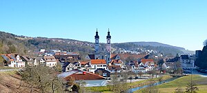
Zwiefalten is a municipality in the Reutlingen district about halfway between Stuttgart and Lake Constance . It is known for the former Zwiefalten Abbey (today the Center for Psychiatry), whose monastery church is one of the main attractions of the Upper Swabian Baroque Route .
geography
Geographical location
The name of the place derives from its location in the valleys of the Zwiefalter Aach and the Kessel-Aach . Zwiefalten is part of the Swabian Alb biosphere area with 44.3% of its boundary .
geology
A geological feature of the Swabian Alb is the Gauing travertine , also called Gauing marble .
Community structure
The municipality of Zwiefalten consists of the following parts of the municipality:
- The villages of Baach, Gauingen , Gossenzugen, Hochberg, Mörsingen, Sonderbuch, Upflamör and Zwiefalten
- The hamlet of Attenhöfen
- The Loretto, Bühlhof and Straubinger farms
In the municipality there are several abandoned , no longer existing settlements: Gauberg and Steinhausen, mentioned around 1100 as Gouwiberc , to which a field name indicates in the municipality of Gauingen; Offenhausen in the Mörsingen part of the municipality; the two settlements of Elnhausen (as Ellinhusin ) and Katzenstaig (as Kazzunsteige ) mentioned in 1089 and the settlement of Weschlinshülbe in the municipality of Upflamör, mentioned in 1272 as Weschelinshulwe .
Neighboring communities
The following cities and communities border the community of Zwiefalten (listed clockwise , starting in the north) and belong to the Reutlingen district or the Alb-Danube district ¹ and the Biberach district ²:
Hayingen , Emeringen¹ , Riedlingen² , Langenenslingen² and Pfronstetten .
history
Until the 19th century
Zwiefalten was first mentioned as a Zwivaltum in a document from King Ludwig IV of June 15, 904. The places Mörsingen and Gauingen also appear there.
The place owes its importance to the former Benedictine monastery Zwiefalten , which was founded in 1089 by monks from Hirsau . Counts Luitold von Achalm and Kuno von Wülflingen and their ministerials donated extensive foundations to the monastery. At first there was also a women's monastery in the village, but it was probably abandoned in the course of the 14th century; Presumably, today's cemetery church is the former church of the nunnery. By the 15th century, the monastery succeeded in acquiring a consolidated territory on the Swabian Alb . However, the peasants looted the monastery in the Peasants' War of 1525; it is said to have come to a battle near Tigerfeld in which the farmers suffered a defeat.
In 1750, the Benedictine monastery was elevated to a fully confirmed imperial abbey by buying itself out of the Württemberg umbrella bailiff through high monetary payments . The area of the Zwiefalten monastery now comprised 14 villages.
On the occasion of the secularization in 1803, the monastery was forcibly dissolved. In 1812 the royal Württemberg sanatorium was set up in the monastery buildings.
20th and 21st centuries
As part of the National Socialist murders of Action T4 , known as euthanasia , the state sanatorium and nursing home in Zwiefalten became an interim storage facility for the Grafeneck Castle killing facility . This started operations in January 1940. At least 1673 mentally ill women, men, young people and children were transferred via Zwiefalten to other state institutions or to Grafeneck in 1939/40. The so-called “ gray buses ” of the charitable Krankentransport GmbH (Gekrat) were a constant local scene during this time. The temporarily transferred patients and residents came from Bedburg-Hau, Ellwangen, Fußbach, Heggbach, Kaufbeuren, Konstanz, Kork, Krautheim, Liebenau, Mariaberg, Rastatt, Sinsheim and Stetten im Remstal. On April 2, 1940, the first transport with 50 women left Zwiefalten. By December 9, 1940, more than 1000 patients from Zwiefalten had been deported to Grafeneck in 22 transports and killed. Even after the end of the central Nazi euthanasia center in Grafeneck in December 1940, the murder of patients in Zwiefalten with a syringe filled with morphine or trional continued. In 1949 the former director Martha Fauser (director from 1940 to 1945) was sentenced to a prison term of only one year and six months for the “crime of manslaughter”. A memorial stone in the institution's cemetery commemorates this event.
Today the center for psychiatry of the Zwiefalten Minster Clinic is located in the former monastery complex .
Incorporations
Baach with Attenhöfen
Incorporated in 1938 (535 m above sea level; 260 inhabitants)
Baach is on the road to Riedlingen in the Aachtal. Attenhöfen is a hamlet of four farms on a hill above the right bank of the Aach and the southernmost place in the Reutlingen district. In the district of Baach there are still remnants of Baach Castle and the defunct Rieder Castle .
Gauingen
![]() Incorporated on January 1, 1975 (738 m above sea level; 140 inhabitants)
Incorporated on January 1, 1975 (738 m above sea level; 140 inhabitants)
Gauingen is located on the Hochalb on the road to Reutlingen (B 312). It is a three-part street village that stretches down from the plateau into a lateral valley basin of the Zwiefalter Aach. Gauingen is known for its travertine deposits .
Gutter trains
Incorporated in 1938 (545 m above sea level; 120 inhabitants)
Gossenzungen is located northwest of Zwiefalten in the valley of the Zwiefalter Aach.
Hochberg
Came on January 1, 1975 with Gauingen (685 m above sea level; 80 inhabitants)
Hochberg lies five kilometers above Zwiefalten in a westerly direction on the edge of the Tobeltal valley.
Mörsingen
Incorporated on February 1, 1972 (661 m above sea level; 100 inhabitants)
Mörsingen is located in a valley on the Swabian Alb, around 5 km southwest of Zwiefalten.
Special book
![]() Incorporated on January 1, 1975 (674 m above sea level; 190 inhabitants)
Incorporated on January 1, 1975 (674 m above sea level; 190 inhabitants)
Sonderbuch is located on the slope of a side valley northeast of Zwiefalten.
Upflamor
Incorporated on January 1, 1974 (740 m above sea level; 90 inhabitants)
Upflamör is the highest district and is located west of Zwiefalten.
There are different derivations for the unusual name. According to one explanation, it resulted (probably) from the exposed location above the valley of Zwiefalten. In spring and autumn there is often a sea of fog in this area, over which the place Upf (= over) la (= dem) mör (= sea) is enthroned.
Another derivation explains: “The explanation for Upflamör is therefore very simple: There is also a place nearby called Pflimmern. And “plowing” is the “land on which plum trees stand”. Upflamör means nothing more than “Oberpflumper”; that is, the plowing that was founded further up - it is the highest place there far and wide. So Upflamör: above the plum trees. "
Population development
The population figures are census results (¹) or official updates from the State Statistical Office ( main residences only ).
|
religion
The entire area around Zwiefalten remained Catholic after the Reformation.
After the transition to Württemberg at the beginning of the 19th century, Protestant residents also moved there. In 1844 a parish administration was established in Zwiefalten and in 1860 a separate Protestant parish was established. Today's evangelical parish of Zwiefalten includes the town of Zwiefalten and its districts, the districts of Geisingen , Huldstetten and Tigerfeld in the Pfronstetten community and the districts of Bechingen , Zell and Zwiefaltendorf in the town of Riedlingen in the Biberach district. No church of its own was built in Zwiefalten. The church services of the congregation take place in the chapter house of the Zwiefalten monastery. In 1884 a branch congregation was founded in Hayingen, which was given its own church building in 1953 and today, as an independent Protestant congregation in Hayingen, forms an overall congregation with the Zwiefalten congregation.
The Protestant residents of the Zwiefalten district of Upflamör were only reclassified to the parish of Zwiefalten in 1983. Before that they belonged to the parish of Pflimmern in the church district of Biberach. Until 1951, the Protestant residents of Uigendorf also belonged to the parish of Zwiefalten. In 1951 Uigendorf was reclassified to the church district of Biberach and assigned to the parish of Riedlingen. Until 1983, the Protestant residents of the community Emeringen and the Obermarchtal districts Datthausen and Reutlingendorf also belonged to the parish of Zwiefalten. In 1983 they were reclassified to the parish of Blaubeuren and assigned to the parish of Munderkingen.
politics

Municipal council
the municipal council is elected according to the procedure of the false sub-district election. The number of local councils can change due to overhang mandates . After the last election, the municipal council has 15 members (2009: 14). The municipal council consists of the elected voluntary councilors and the mayor as chairman. The mayor is entitled to vote in the municipal council. The local elections on May 25, 2014 led to the following official final result:
| CDU / civil electoral association | 72.7% | 11 seats | 2009: 73.3%, 11 seats |
| Free voters Zwiefalten / SPD | 27.3% | 4 seats | 2009: 26.7%, 3 seats |
mayor
The mayor is elected for an eight-year term. Matthias Henne's current term of office ends in 2022.
- 1962–1990: Karl Ragg ( CDU )
- 1990–2014: Hubertus-Jörg Riedlinger ( SPD )
- Since 2014: Matthias Henne ( CDU )
coat of arms
Blazon : "In blue, two interwoven silver rings, one above the other, which form three segments of a circle in which seven (3: 1: 3) six-pointed golden stars appear."
In the mayor's office seal, the later heraldic figures - although still without a shield - were apparently depicted as early as the 19th century. Presumably, the two intertwined rings should point to the community name, while the seven stars are derived from the coat of arms of the former Zwiefalten monastery. The colors of the coat of arms were determined in consultation with the Stuttgart archives department at the meeting of the municipal council on December 15, 1933. The Reutlingen District Office awarded the flag on March 9, 1982.
On a blue background there are two intertwined rings that symbolize the confluence of the Zwiefalter-Aach and the Kessel-Aach. The seven golden stars come from the coat of arms of the former Counts of Achalm .
Town twinning
-
 La Tessoualle , western France , since August 12, 1973
Culture and sights
Zwiefalten is on the Upper Swabian Baroque Road .
Museums
- Württemberg Psychiatry Museum
- Peterstormuseum: In the former school building of the monastery employees, a local museum
Buildings
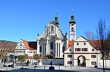
- The Minster of Our Dear Lady , the church of the abbey which was secularized in 1806 , is considered a masterpiece of the German late baroque . The construction was started in 1739 by the brothers Joseph and Martin Schneider and completed by Johann Michael Fischer by 1765 . The rich furnishings of the church include a late Gothic miraculous image from 1430 as well as baroque ceiling frescoes and an altarpiece by Franz Joseph Spiegler , frescoes by Andreas Meinrad von Au , stucco work by Johann Michael Feuchtmayer the Elder. J. , also sculptures and a choir stalls by Johann Joseph Christian .
- The services of the Protestant parish take place in the chapter house of the Zwiefalten monastery , which was built in 1668 by Peter Thumb.
- The Great Heuneburg (Upflamör) is an early Celtic rampart in the forest near Upflamör. The 5 hectare area is between the 8th and 6th centuries BC. Colonized in BC and gives an idea of the way of life at that time due to the existing walls and rock remnants.
Natural monuments
- Wimsener Höhle , also Friedrichshöhle, a water cave known since 1447, accessible with a boat. The total length is 723 m, but only 263 m have been measured.
- Aachtopf (Kesselbach) rises in the valley floor of the Dobeltal, similar to the Blautopf near Blaubeuren
- Schlossberg special book with Burgstall Castle special book
Regular events
- The fools guild Rälle e. V. runs the Swabian-Alemannic carnival in town. The main character of the Zwiefalter Fasnet is the "Klosterrälle", a fool in a cat mask, created in its present form in 1962. Further figures are the "Teutschbuch-Gockel" (since 1977), the "Gauinger Bär" (since 1978), the "Zwiefalter Hansel" (since 1982) and the "Krattenweib" also called "Korbfrau" (since 1975). The fool's guild is a founding member of the Association of Free Upper Swabian Fool's Guilds (VFON), which was founded in 1969.
Economy and Infrastructure
The Zwiefalten transmitter is a filler transmitter for Südwestrundfunk. It is located in the forest, about one kilometer south of the town of Zwiefalten.
traffic
Zwiefalten is on federal highway 312 . This connects the community in the northwest with Reutlingen and in the south with Riedlingen .
The Public transport is by the Verkehrsverbund Neckar-Alb-Donau guaranteed (NALDO). The community is located in honeycomb 227.
Facilities

- Zwiefalten owns a center for psychiatry with the Zwiefalten Minster Clinic .
- The community was also the seat of the dean's office Zwiefalten of the diocese Rottenburg-Stuttgart , which today belongs to the dean's office in Reutlingen-Zwiefalten , based in Reutlingen.
education
- Münster School Zwiefalten
- Health and Nursing School
Personalities
Sons and daughters of the church
- Heinrich (I) von Zwiefalten (* in the 13th century; † in the 13th century), Benedictine, prior of the Ochsenhausen monastery from 1238 to 1263
- Erhard Knab (around 1435–1480), physician from the Electoral Palatinate, university professor, specialist book author and four-time rector of Heidelberg University
- Carl von Sallwürk (1802–1864), Hohenzollern governor
- Gustav Werner (1809–1887), Protestant pastor and founder of the Gustav Werner Foundation
- Oswald Bockmayer (1820–1869), born in Gossenzugen, Oberamtmann in Württemberg
- Gerhard Ziegler (1902–1967), architect and spatial planner
Personalities who have worked on site
- Ernest Weinrauch (1730–1793), composer and Benedictine priest in the Zwiefalten monastery
- Conradin Kreutzer (1780-1849), composer and conductor, was a student of wine smoke and visited the Benedictine Abbey Zwiefalten school
Others
- Zwiefaltener calendar , illuminated codex from 1145, which is in the Württemberg State Library in Stuttgart as Cod. Hist. fol. 415 is kept.
- Zwiefalter monastery brewery
- Upflamör country school home
- A poem by Robert Gernhardt has the location (especially the psychiatric clinic) on the subject.
- The city described in Bodo Kirchhoff's novel Zwiefalten , however, is not identical to the actual place Zwiefalten.
Web links
ditto from Bach , Gauingen , special book .
Individual evidence
- ↑ State Statistical Office Baden-Württemberg - Population by nationality and gender on December 31, 2018 (CSV file) ( help on this ).
- ↑ GeoPark Adventure . In: Swabian Alb! traveling there, of course, the nature place to go . ed. from the Swabian Alb Tourism Association. Bad Urach 2010; P. 6 f., Here p. 7
- ^ The state of Baden-Württemberg. Official description by district and municipality. Volume VII: Tübingen administrative region . Kohlhammer, Stuttgart 1978, ISBN 3-17-004807-4 . Pp. 89-92
- ↑ Memorial sites for the victims of National Socialism . A documentation, volume 1. Federal Agency for Civic Education, Bonn 1995, ISBN 3-89331-208-0 , p. 106
- ↑ a b Federal Statistical Office (ed.): Historical municipality register for the Federal Republic of Germany. Name, border and key number changes in municipalities, counties and administrative districts from May 27, 1970 to December 31, 1982 . W. Kohlhammer, Stuttgart / Mainz 1983, ISBN 3-17-003263-1 , p. 538 .
- ^ Federal Statistical Office (ed.): Historical municipality directory for the Federal Republic of Germany. Name, border and key number changes in municipalities, counties and administrative districts from May 27, 1970 to December 31, 1982 . W. Kohlhammer, Stuttgart / Mainz 1983, ISBN 3-17-003263-1 , p. 530 .
- ^ Federal Statistical Office (ed.): Historical municipality directory for the Federal Republic of Germany. Name, border and key number changes in municipalities, counties and administrative districts from May 27, 1970 to December 31, 1982 . W. Kohlhammer, Stuttgart / Mainz 1983, ISBN 3-17-003263-1 , p. 537 .
- ↑ Where the name "Upflamör" comes from . Broadcast on April 13, 2018, Landesschau Baden-Württemberg, SWR Baden-Württemberg, accessed on January 29, 2020.
- ↑ Konrad Kunze: 1000 answers Where does the place name "Upflamör" come from? . Status: April 11, 2019, 2:17 pm, Landesschau Baden-Württemberg, SWR Baden-Württemberg, SWR Wissen, accessed on June 5, 2020. - Konrad Kunze cites a book by a “Ulm journalist” as the source (unfortunately without his name to name: Wolf-Henning Petershagen) called "The Truth About Deppenhausen".
- ^ Website of the parish of Zwiefalten
- ^ Website of the parish of Hayingen
- ^ District and community arms in Baden-Württemberg Volume 4, page 113; Publisher: Landesarchivdirektion Baden-Württemberg 1987 ISBN 3-8062-0804-2
- ↑ Tourist routes . In: Swabian Alb! traveling there, of course, the nature place to go . ed. from the Swabian Alb Tourism Association. Bad Urach 2010; P. 10 f.
- ↑ Eckart Roloff and Karin Henke-Wendt: A Benedictine monastery as a "state mental institution". (Württembergisches Psychiatriemuseum) In: Visit your doctor or pharmacist. A tour through Germany's museums for medicine and pharmacy. Volume 2, Southern Germany. Verlag S. Hirzel, Stuttgart 2015, pp. 82-84, ISBN 978-3-7776-2511-9
- ↑ Ursula Pechloff: Münster Zwiefalten, Our Dear Lady. Peda Verlag, Passau, without ISBN, without year


