
Bergen Training Area
|
Bergen Training Area |
|
|---|---|
 Internal association badge |
|
| Lineup | 1935 |
| Country |
|
| Armed forces | armed forces |
| Organizational area |
|
| Insinuation | Territorial Tasks Command of the Bundeswehr |
| Location | Mountains |
| management | |
| Commander BerTrÜbPlKdtr North | Colonel Jörg Wiederhold |
| Commander TrÜbPl Bergen | Lieutenant Colonel Michael Helftenbein |
Coordinates: 52 ° 48 ' N , 9 ° 49' E


The Bergen military training area ( TrÜbPl Bergen , also NATO shooting range Bergen-Hohne ) in the southern part of the Lüneburg Heath ( Lower Saxony , Germany ) is with an area of 24,900 hectares with an extension of 26 km in north-south direction and 18 km in east West direction one of the largest military training areas in Europe.
It was set up by the Wehrmacht from 1935 to the west of the eponymous town of Bergen . After the end of the Second World War it was taken over by the British occupation forces in 1945 and continuously expanded. Since the 1960s, the area has also been, and is predominantly, used by the German Armed Forces . Other NATO forces that hold exercises here, besides the British, are the Dutch and Canadians . Until their withdrawal in September 2015, the British used most of the barracks (troop camps) in Oerbke and Bergen.
geography
location
The military training area extends on both sides of the border between the Heidekreis and the district of Celle . This part of the Lüneburg Heath is also called Heidmark . The northernmost area begins directly at the Soltau -Süd exit of the A7 federal motorway . From here the eastern border of the square runs to Bergen, first near the federal highway 3 and then on to the state road L 298. The western border is directly parallel to the A 7 motorway, past Bad Fallingbostel to the south of the Walsrode motorway triangle (A7 / A27 ). The southernmost area borders on the 3,500 hectare Bundeswehr exercise area Ostenholzer Moor , which is no longer part of the NATO military exercise area. Under local law, the military training area belongs to the community-free districts of Lohheide and Osterheide , which emerged in 1945 from the manor district of Platz Bergen, which was founded in 1938 .
The course is located around 40 km north of Hanover, around 60 km southeast of Bremen and around 60 kilometers south of Hamburg. The highest point is the Falkenberg at 150 m above sea level. NN , its lowest point is 40 m above sea level. NN in the south of the place, on the border to the Ostenholz Moor. The “most remote” point in Germany was measured on the site at a distance of 6.3 km to the next building.
Landscape image
In particular, the central part of the military training area consists of heathland . In its northern part is the small Wittenmoor, just outside of its northeastern edge is the Great Moor near Becklingen and in the south the Ostenholzer Moor . The remaining parts consist of forest areas. The Bannetz Moor and the Meißendorfer Ponds are already outside the restricted area in the south . In 2012, two wolves could be safely detected for the first time at the military training area. Since 2013, a pair of wolf siblings has been identified that regularly gives birth to puppies.
In the northwest, outside the military training area, a section of the middle reaches of the Bohemian flows . In the southeast and south the Meiße flows largely over the practice area. Both rivers are north-eastern tributaries of the Aller . The outermost north-western part has many smaller streams that flow into the Böhme from the east. Approximately in the center of the square are the seven stone houses , a group of large stone graves. The way there is open to the public on certain days. The Hohe Bach flows directly past them. Nearby is the small Meiersee, through which the Meierbach flows in a south-westerly direction. These two streams drain the central and southern parts of the military training area. The southeast part is drained via the Liethbach, on which the Bredebeck Castle is located. These three mentioned streams are tributaries of the Meiße. The Fischendorfer Bach, a south-eastern tributary of the Böhme, flows in the northwest area. In the west is the Fahrenholzer Bach, later called Krelinger Bach, it has its mouth in Hodenhagen . All the mentioned streams have in common that they form many pond areas in their course.
In a south-west-north-east direction, a heavily forested moraine landscape , the "Becklinger Holz", stretches across the military training area , including these elevations: Falkenberg ( 150 m above sea level ), Hakenberg (143 m), Goldbockenberg (129 m ), Staffelberg (126 m), Rehberg (125 m), Sinnberg (122 m), Hengstberg (121 m), Tutenberg (116 m), Galgenberg (110 m), Kahlberg (104 m), Kallenberg (103 m), Fuhrberg (102 m), Horstberg (98 m).
- Bergen Training Area

The Meiersee on the military training area

Marshy natural landscape
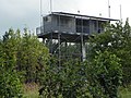
Control tower Panzerschießbahn 20

Area at the SB 9 shooting range. The small black areas of fire are caused by the falling of tracer ammunition .

Fire protection strips are intended to prevent the spread of forest fires that can arise from the use of tracer ammunition

Adjustment disc for battle tanks on the shooting range

Training area with armored tracks
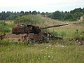
Tanks as a target for target practice

Cardboard comrades as targets


history


As early as the 19th century, the Hanoverian army was using two smaller parade grounds here .
East of Becklingen , in the forest "Becklinger Holz" , which is today on the military training area, the last wolf in the Lüneburg Heath was seen and shot on January 13, 1872 . The shooter was the forester of Wardböhmen H. Grünewald, former personal hunter of King George V of Hanover , the last king of Hanover. To commemorate this, a " Wolfsstein " was set up there in 1929 by the General German Hunting Protection Association, Hanover District Association .


The first planning for the construction of the military training area began in August 1934 in connection with the armament of the Wehrmacht . Due to the sparse population and the varied landscape, this area was chosen to create the largest training area for the Wehrmacht. On September 15, 1934, the local farmers learned of the establishment of a military training area. On October 1, 1934, a group of farmers from the affected area gathered at Platz Sieben Steinhäuser for advice . A delegation drove to Goslar on the same day to present the concerns to the “ Reichsbauernführer ”. On March 18, 1935, more than 80 farmers drove to Berlin to find out about their future and the planned relocation of their farms. Despite popular resistance, around 3,650 residents from 25 communities had to leave their homes within a few years. Among other places disappeared Deil , Hörsten, Hoppenstedt, Hohne, Hohnerode, Manhorn, Lohe, Gudehausen, Ettenbostel , Oberndorf Mark , Oberhode , Benhorn , Harlem , driving wood , Böstlingen , Pröbsten , Kolk , Südbostel, Nordbostel, Obereinzingen , Untereinzingen , Achterberg , Wense and parts of Oerbke , Ostenholz and Hasselhorst from the map.

After the “Law on Land Procurement for the Purposes of the Wehrmacht” of March 29, 1935 came into force, the Reich Ministry of War ordered the purchase and expansion of the Bergen military training area. The Reichsumsiedlungsgesellschaft Berlin was entrusted with the acquisition of the land and the procurement of replacement land. On October 28, 1935, it presented a task plan. The history of the farms and villages affected as well as the archaeological monuments, including the seven stone houses, should be recorded and documented in order to preserve them for posterity. The state archaeologist Hans Piesker from Hermannsburg was commissioned with this. 108 tumuli he has scientifically researched 1935-1941 and again in 1944 and inventoried.
Around 100 barracks, 50 horse stables and 40 large garages were built on the eastern edge of the site, near the villages of Hohne and Belsen , at the time known as the "East Camp" , as well as a lazaratt, depots and a disc courtyard where targets were made for shooting. In the south of these barracks there was an army ammunition system for infantry ammunition. On May 4, 1936, the first units moved into their accommodation.
On the western edge of the site, near the village of Oerbke, known at the time as the “Westlager” , further barracks, horse stables, garages and depots were built between April 1, 1937 and 1942.
From August 1, 1938, military exercises took place over the entire area.
In the course of the establishment of the military training area, the part of what was then Reichsstrasse 3, now Bundesstrasse 3 , which ran over the training area on the far eastern edge , had to be relocated. Between Wardböhmen and the junction Soltau-Süd of the A 7 a new route was built in 1936/37 parallel outside the square. The military uses the old route for training purposes.
After 1945
After the end of the Second World War , the training area was taken over by the British armed forces on April 15, 1945 . Initially they only used the eastern part of the field as the “Royal Armored Corps Training Center” .
From 1945 to 1947, around 1.5 million displaced persons from the east had to be taken into the British zone of occupation . The British military government decided to open up empty farms, houses and barracks in the outskirts of the manor districts Lohheide and Osterheide for the refugees to repopulate. Around 6,000 applicants registered. Farmers, including some of the former residents of the square, were able to build up a new livelihood here on 145 settler and part-time jobs. Many refugees were also accommodated in the former Achterberg recreation home . At the time it was hoped that the military training area would lose its function as a firing range after the war, but this did not come true.
Refugees were even housed in the barracks of the former Bergen-Belsen concentration camp , which the British did not immediately burn down in May 1945. This barrack settlement was called " Neu-Hohne ". In addition , around 500 refugees, including many Black Sea Germans , were accommodated in the former Wehrmacht barracks in Gudehausen , two kilometers southwest of Bergen-Belsen . These two residential camps were demolished in the early 1950s.
The British continued to expand the practice area until it reached today's limits. Some of the newly settled areas, such as Oerbke -Ost, had to be cleared again in autumn 1953 due to military needs by the British Army. After the extension of the shooting range in the northern part of the military training area, Achterberg had to be abandoned in 1954. In 1961 at the latest, the other last lease contracts also expired, and the residents - among others - of the towns of Oberhode and Ostenholzer Moor had to leave their businesses and apartments.
During the Cold War , the square was used intensively, mainly due to the strong concentration of troops in the North German Plain, which is strategically important for NATO .
At times there were also considerations to merge the Munster and Bergen military training areas .
From 1957, the Bundeswehr was allowed to use the training area again for the first time. She maintained a liaison team there at the British headquarters. On April 1, 1958, the British Army handed the training area over to the Bundeswehr. The base became the largest training area in Europe and was one of the training centers for NATO ground troops in the Federal Republic of Germany . In the south-west there is the Ostenholz camp , which also has a motorway connection in the immediate vicinity. This camp is only held ready for training troops, but has permanent accommodations and massive buildings for the site administration and home companies.
After the end of the Cold War, the number of soldiers was significantly reduced. However, the facility is still very important. The area is used by the Bundeswehr and NATO troops. The British Army stationed here until September 2015 has withdrawn completely. On March 17, 2016, the Dutch 43rd Mechanized Brigade was subordinated to the 1st Panzer Division of the German Army. The mixed German-Dutch tank battalion 414 was put into service in Bergen and placed under the 43rd Mechanized Brigade.
At the beginning of 2017 it was announced that the armed forces of the United States of America were considering the stationing of around 4,000 soldiers in the Lüneburg Heath. But other locations are also being discussed.
Current usage


The originally built shooting ranges and their use:
| Shooting range | put into operation | use |
|---|---|---|
| I. | in 1936 | Tank shooting range |
| II | in 1936 | Infantry range |
| III | in 1936 | Infantry rifle range + anti-aircraft |
| IV | in 1936 | Infantry range |
| V | in 1936 | Infantry and artillery range |
| VI | in 1936 | Tank shooting range |
| VII | in 1939 | Tank shooting range |
| VIII | in 1939 | Tank shooting range |
| IX | in 1939 | Tank shooting range |
| X | in 1939 | Tank shooting range |
| XI | in 1941 | Tank shooting range |
| XII | in 1944 | Tank shooting range |
Today there are 15 shooting lanes for battle tanks and armored personnel carriers on the site , all of which can also be used as handgun lanes . In addition, there are 19 firing ranges for hand-held anti-tank weapons , 12 of which are suitable as combat firing ranges . There are also 16 artillery positions at the edge of the field and two external artillery positions outside the area. Further, rifle / machine gun -Schießbahnen, hand grenade items , as well as facilities for air defense , training villages , Tiefwatanlagen and camping sites available.
The armed forces of the NATO member countries of Germany, the Netherlands, Great Britain and Belgium regularly practice on the military training area. In particular, the Leopard 2 and Challenger 2 battle tanks , the AH-64 Apache combat helicopter and the 2000 self- propelled howitzer are used. The use of unmanned reconnaissance drones (UAV) is being practiced to an increasing extent . The use of training and combat ammunition from aircraft is possible.
Headquarters
Since January 1, 2015, the command center of the Bergen military training area has been part of the Northern Training Area Command . The military training areas Bergen, Munster and Putlos , with the Todendorf branch, as well as the Nordhorn air / ground shooting range and the German military representative (DMV) Senne / Haltern are subordinate to this. The commander of the BerTrÜbPKdtr NORD, Colonel Jörg Wiederhold and the commander of the Bergen Training Area Command, Lieutenant Colonel Michael Helftenbein are based in Lohheide .
Landscaping
The Federal Forests division of the Federal Agency for Real Estate is responsible for maintaining the forest and open spaces in the military training area as well as for the necessary reforestation . The commandant's office agrees with the responsible forest office about a use of the wooded areas that is compatible with the landscape maintenance requirements and the most careful use of the paths and roads in the square that are used by tanks.
Since this is a military zone is where normally no civilians as walkers on the road, find deer , fallow deer and wild boar in front of favorable living conditions in forested parts. The high game density leads to pronounced damage to tree crops from browsing. The Federal Forests division counteracts browsing through hunting with appropriate shooting plans. The command office informs the Federal Forestry Office about the places and times of the military exercises, so that the hunters can also stay in the areas of the individual shooting lanes during the respective breaks. You are responsible for not stepping on one of the numerous duds .
Military target practice with tracer ammunition increases the risk of forest fires due to smoldering fires that develop in the needle litter of the forest floor. The Federal Forests division counteracts this with fire protection strips in the forest and the creation and maintenance of extinguishing water ponds .
public relation
Once a year in autumn, parts of the square are released for popular cycling . For cyclists there are three different routes, on paved roads, with different lengths of about 25 km, 45 km and 80 km. Inline skaters can cover a distance of around 30 km. Start and finish are Hasselhorst and Oerbke . At these points and near the seven stone houses, there are refreshment stations. Between 2,000 and 3,000 people regularly take part. Guided sightseeing tours by bus are also offered at irregular intervals.
Cultural monuments and sights


The following cultural monuments and sights are located on and near the Bergen-Hohne military training
area : In the area of the community-free district of Lohheide :
- near Belsen :
- historic camp site of the former Bergen-Belsen concentration camp
- Bergen-Belsen concentration camp documentation center
- Soviet prisoner of war cemetery in Hörsten. 14 mass graves in which Soviet prisoners of war were buried, with an estimated 50,000 dead (officially recorded: 23,215 dead).
- DP camp Belsen for displaced persons as well as "tent theater cemetery " and "Kapo cemetery" on the barracks area in Belsen (on the barracks area, therefore only accessible by arrangement)
- German war grave cemetery Lohheide
- A memorial of honor for Colonel General Werner Freiherr von Fritsch in Hoppenstedt (Lohheide)
- Bredebeck Castle on Liethbach (part of the Bergen-Hohne camp). Since 1945 it has been the officers' mess of the headquarters of the British Army . Occasionally the British used it as a guest house. As such, it has also served as accommodation for the British royal family . The castle was returned to the German authorities in May 2015 on the occasion of the withdrawal of the British Army. The subsequent use, which is incumbent on the Federal Agency for Real Estate Tasks , has since been unclear.
In the Osterheide area and its vicinity:
- in Oerbke (in the west):
- Cemetery of the Nameless , a war grave site in which around 30,000 Soviet prisoners of war from World War II were buried in mass graves
- in and near Ostenholz (in the southwest):
- Half-timbered church with a wooden tower from 1724
- Hoher Stein , also Riese von Hanglüß , a memorial stone for the evacuation of the communities in 1936 for the purpose of creating a military training area
- Seven stone houses , large stone graves from the Neolithic Age in the south of the military training area
- in Wense (in the northwest):
- Manor chapel, magnificent church from 1558, and the former manor house
Protest and resistance
The training area is not without controversy among the population of the surrounding communities. Due to the military use, residents are exposed to noise during target practice and tank movements. There are also indications of soil pollution by heavy metals (ammunition residues). Furthermore, the large-scale military restricted area leads to a peripheral location of the neighboring municipalities.
In the early 1990s there was a major protest movement against the military training area for the first time. With the end of the Cold War, several hundred people joined the "Citizens' Initiative for the Dissolution of the Bergen Military Training Area / Association for a Military-Free Heath." together and called for an end to military operations. The citizens' initiative achieved the creation of an extensive conversion study under the direction of Dr. Burkhard Luber through the "Die Schwelle" foundation, which shows alternatives to military use.
Since 2013 the "Initiative Biosphärengebiet Hohe Heidmark e.V." for the creation of a UNESCO biosphere reserve in the area of the military training area and the surrounding communities. The reason for the establishment of the initiative was the withdrawal of the British Army in 2015, which meant that one of the main users of the military training area ceased to exist and economic problems arose for the former garrison locations Bad Fallingbostel and Bergen . Instead of military use, the initiative calls for the area to be opened up to nature-friendly tourism. This should lead to the creation of jobs in the neighboring municipalities. The initiative organizes information events and bike tours, among other things. The creation of a biosphere reserve is also mentioned as a "possible sensible option" in the conversion study.
One of the aims of the initiative is to preserve the historic Wünninghof in Ostenholz. The farm was one of the oldest and largest inns in the Südheide and is currently threatened by demolition by the Federal Agency for Real Estate . The farm is only a few hundred meters from a shooting range next to the Ostholz church.
The headquarters of the initiative with around 60 members is Bad Fallingbostel, the association is currently chaired by Arne Hilbich and Michael Kaufmann.
See also
literature
- Olaf Mußmann : History of the military training area in Bergen. Münster 1996, ISBN 3-8258-2753-4 .
- Hinrich Baumann: The Heidmark. Change of a landscape. The history of the Bergen Training Area. Walsrode 2005, ISBN 3-00-017185-1 .
- Andreas Hesse: The Judas wage. Rowohlt Verlag, Reinbek bei Hamburg 2005, ISBN 978-3-8052-0800-0 (detective novel set on the military training area and in Eichendorf (= Meißendorf )).
- Burkhard Luber (Hrsg.): Civilian uses of the military training area mountains . Ottersberg 1997. ISBN 3-8258-2431-4 .
Web links
- Official data on streitkraeftebasis.de (PDF)
- Bergen Training Area on Religte.com
- Hard targets of the military training area
Individual evidence
- ↑ https://www.epochtimes.de/wissen/forschung/studie-kaum-freiflaechen- Zwischen-gebaeuden-in-deutschland- a2983280.html
- ↑ Wolf proof on the TrpÜbPl Bergen
- ↑ In detail: The Becklinger Holz between Bergen and Soltau , Matthias-Blazek.eu, accessed on February 8, 2014.
- ↑ The last wolf of the Lüneburg Heath , Lausitz-Wolf.de.
- ↑ Hosang, Joachim: "Würger vom Lichtenmoor", in: Land & Forst 35/1998, p. 41.
- ↑ Pictures of the Wolfsstein - coordinates in Becklinger Holz: 52 51 38 N 09 51 46 E
- ↑ This scorn is not the scorn (Samtgemeinde Lachendorf). See: (archive.org) Community-free district ( Memento from June 13, 2004 in the Internet Archive ) Lohheide , Neu-Hohne and the map of the former community boundaries .
- ↑ "Former villages on the Bergen-Belsen military training area" .
- ↑ Destruction of the Ostheidmark in the time of National Socialism .
- ^ Nessenius (1985): The cultural landscape change in the northern part of the Bergen military training area, 140 pages (unpublished)
- ^ Law on Land Procurement for the Purposes of the Wehrmacht
- ↑ German-Dutch tank battalion 414 put into service in Bergen
- ↑ American forces to Bergen? ( Memento from March 14, 2017 in the Internet Archive )
- ↑ Images of practice targets ("hard targets") .
- ↑ https://www.bundesimmobilien.de/7619362/naturschutz-landschaftspflege
- ↑ https://www.bundesimmobilien.de/7627746/forstliche-produkte#
- ↑ List of graves at the German war grave cemetery Lohheide .
- ^ Location of the German war grave cemetery Lohheide .
- ↑ Schloss Bredebeck is in danger of decay haz.de, May 5, 2015
- ↑ "Hanglüß" was a district of Obereinzigen (see map of the former borders at the Bergen military training area).
- ↑ Inscription of the "Hohen Stein": "To the memory of the Heidjer willing to make sacrifices from the former villages of Hörsten, Hoppenstedt, Hohne, Hasselhorst, Hohnerode, Manhorn, Lohe, Gudehausen, Ostenholz, Ettenbostel, Oberhode, Benhorn, Hartem, Fahrenholz, Böstlingen, Pröbsten, Kolk, Sudbostel, Nordbostel, Örbke, Obereinzingen, Untereinzingen, Achterberg, Wense. The command office of the Bergen Training Area. March 1938. "
- ^ Initiative of the Hohe Heidmark biosphere area
North area: Bergen | Munster North | Munster South | Nordhorn (L / BSchlPl) | Senne | Putlos
East area: Altengrabow | Altmark | Jägerbrück | Klietz | Upper Lusatia
South area: Baumholder | Grafenwohr | Hammelburg | Heuberg | Hohenfels | Wild spots