
Niep (old Rhine channel)
_(9).JPG)
The Niep , also known as the Niepkuhlenzug or under various other names (see below), is a silted up old river channel of the Rhine , which is a swampy lowland from Krefeld over a multitude of meander loops through the left Lower Rhine area to Vluyn and (under another name) further up Issum draws. From here the channel can be traced into the catchment area of the Niers and thus ultimately to the Meuse .
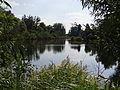
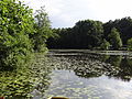
Along the channel, in which a bog has formed almost its entire length , a multitude of smaller and larger ponds and lakes (mostly former peat hollows ) are lined up like a string of pearls , which are loosely connected by various streams and ditches. The Niepkuhlenzug with its ecologically valuable wetlands forms one of the most important biotope systems of the Lower Rhine, many sections are under nature protection .
Designations
Niep (also Nep , Neip or Nip ) is a regional field name from the Rhineland, which describes a moist, often covered with flat water area. The same origin is behind the names of Cologne-Nippes , the Niephauserfeld settlement near Rheinkamp- Repelen or the Niepgraben near Rheinberg.
In addition to the original short name Niep , the channel as a whole is also known under various other names: Niepkuhlen or -kuhlenzug , -kanal , -graben or -rinne . Besides the Nieper Kuhlen also Nieper Benden , Bruch , Kendel , Rhein , Altrhein or Altrheinrinne .
Individual sections (or the waters in them) will continue to be referred to with local names (see below).
Emergence
Geological backgrounds
In the penultimate Ice Age , the Saale Ice Age , the glaciers of the inland ice , coming from Scandinavia to the northeast, penetrated into the northern Lower Rhine Plain at the time of their greatest expansion (in the so-called Drenthe stage ) . The ice masses pushed large masses of earth and rock in front of them, piled them up to form compression moraines and thus formed the Lower Rhine ridge , which today extends with interruptions from Krefeld in a north-north-west direction to Nijmegen. Part of this ridge are the Hülser Berg and the Schaephuysener heights . Around Krefeld, the glacier front, marked by the moraine line mentioned above, crossed today's Rhine. Due to the ice and rock masses of the glaciers, the ancient Rhine, coming from the south, was also pushed to the west, towards Niers and Maas .
After the ice had retreated again in the coming warm period, the main stream of the Ur-Rhine initially remained west of the Lower Rhine ridge. It was not until the Younger Dryas Period , at the end of the next (and to this day last) ice age, the Weichselian glacial period , that the primordial Rhine, with the thawing of the Alpine glaciers , especially when the snow melted in spring, resulted in such enormous amounts of water and sediments that it graveled the lower terrace , broke through the Lower Rhine ridge in several places and relocated to its east side, near the current bed. At that time the Ur-Rhine was several tens of kilometers wide in this region.
During its shift to the east, the heavily meandering Rhine, overgrown in numerous tributaries, dug into the lower terrace and left a highly branched system of gullies (Lower Rhine " Kendel " ) and elevations in between (Lower Rhine " Donken " ) with a difference in altitude in the flat landscape of only about 2-3 meters ("Kendel-Donken-Landschaft").
At some point in the Holocene (exact definition uncertain, probably in the Atlantic , i.e. in terms of cultural history in the Mesolithic ) the Nieper arm of the Rhine was separated from the main stream, so that it was no longer flowed through and slowly silted up.
The larger bodies of water along the Niep are mostly open- cast pits full of groundwater for the extraction of peat and semolina (see section Use ).
Use and change by humans
_(5).JPG)
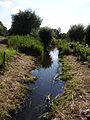
Because of the swampy terrain and the risk of flooding , the lowlands of the Niep are not suitable as arable land or for settlement . Agricultural use occurs mostly as grassland . In the first half of the 20th century, some higher-lying areas of the Niep were drained through drainage ditches and drained and cultivated to the extent that they could be used as arable land.
From the 18th to the late 19th century, the one to two meter thick layer of peat that had formed in the fens was removed in many places . The peat served the poor rural population as an inferior but cheap fuel for house heating . The peat was cut with shovels down to the groundwater level ; At greater depths, trawling nets continued to work because of the water penetrating into the hollow . In addition to the peat, some of the gravel soil underneath was extracted, which was used to improve the soil of arable land.
From the 20th century peat mining ceased and the resulting hollows remained as quarry ponds. Later these waters were often used for fishing and developed and managed as fish ponds .
Because of the hard coal mining in the region, near Kamp-Lintfort and Rheinberg (e.g. Bergwerk West ), mining subsidence also occurred in the Niep area from the 20th century , and since the channel has only an extremely slight gradient, the water drainage became locally disturbed and changed.
From the 1970s, the importance of the Niep and its caves as a biotope was increasingly recognized, but it was only from the late 1980s that more and more areas of the lowland were placed under nature protection (see below).
Today the Niep is also used for local recreation ; In many places (with the exception of nature-protected quiet areas), the area is accessible by walking, hiking and cycling trails. On the banks of the larger bodies of water there are often moorings for rowing and pedal boats ; Motor boats are not permitted. In the protected areas there are paths, footbridges and platforms for nature observation in selected places.
History and local names
_(2).jpg)
The Niep is the continuation of a series of old and side arm loops, which can be identified from the entry into the Lower Rhine Bay, especially to the left of the current course of the Rhine .
On old maps (e.g. Tranchot's topographical survey of the Rhineland ) the Niep Gully can be clearly seen from Bockum , where it is separated from a younger channel that runs from Linn towards Uerdingen . In the densely populated eastern urban area of Krefeld, the channel is only faintly recognizable today by a few green areas and bodies of water that line the former course: The channel runs from the center of Bockum in a right-hand bend to the west over the Sollbrüggenpark and Schönhausenpark and further north through the Allotment garden colony Bockum-West . From here the Moersbach marks the course of the channel, which runs in a long left curve around the city forest with the trotting track .
To the north-west of the city forest, between Verberg and Kliedbruch , the channel meets the eastern flank of the Hülser Berg . The channel turns sharply to the north and follows the course of the Lower Rhine ridge on its east side, past Traar , between Hülser Berg and Egelsberg and on to the town of Niep (so called because of its location near the Niep). From here it goes on the east side of the Tönisberg to Vluyn . Then the lowland loops around the Littard in a left loop as far as Rheurdt .
In its course, the channel or the bodies of water lying in the lowland are known locally by different names. In the Krefeld city forest, where the Moersbach runs over a longer stretch in the Niep lowland, this is also called the Moers or, in the upper area, Holtmoers . The name Niep or Niepkuhlen is used from the Krefeld city forest. The valley between Verberg and Traar is also called Riethbenden . There are several sections of the Niep between Traar and Vluyn: Schuhmachersniep , Kirchwehmsniep , Brucksche Niep and Waldwinkelsniep . At Vluyn, the Niep is called Big and Small Parsick . At Bloemersheim Castle , the Niep forms the castle pond , after which it is accompanied by the Littardsche Kendel to the Littard .
Between Krefeld and Issum, in the area of the Niep, there are a number of former peat hollows, some of which are simply called Niepkuhlen , but some have their own names: Waldwinkelkuhlen, Hacksteinskaulen, Littardkuhlen, Meenenkaule, Pastorskuhle, Kaplanskuhlen, Stammenkuhle, Blink , Spicken, Fleuthkuhle , ...
In the area north of Rheurdt, where the channel crosses the course of the historic Fossa Eugeniana canal , the channel becomes flatter and several channels, some of which are weakly pronounced, branch off to the east. This flat area forms a watershed ; Part of the surface water flows from here over the Littardsche and Eyllsche Kendel and the Fossa Eugeniana to the east, past Kamp-Lintfort and Rheinberg , to the Rhine. However, the larger part (with the Nenneper Fleuth , the Hoerstgener Kendel and the Issumer Fleuth ) flows through a breakthrough valley in the Lower Rhine ridge (between the Schaephuysener Heights in the south and the Bönninghardt in the north) to the west, into the catchment area of Niers and Maas. These channels run past Sassenrath , east around the Oermter Berg with Oermten , past Hoerstgen , to Issum . Behind Issum, the gullies reunite to form a main gully (Issumer Fleuth), which runs in several loops around the Finkenhorst (as Spandicks Ley ), past Aengenesch , Geldern - chapels and betting , all the way to Kevelaer . The Issumer Fleuth flows into the Niers at Winnekendonk , and the channel merges with the wide Niers valley (with the Kendel as a tributary), which ultimately merges into the Maas valley at Cuijk .
Biotope
Flora and fauna
A typical fen biotope has formed along the Niep with extensive swamp and alluvial forest areas , reed beds and great sedge beds . Because of the shallow water, the water areas are covered in many places by lush floating leaf plants.
The wetland provides habitat, feeding, resting and breeding biotopes for many, sometimes rare or endangered species of birds, especially water birds such as the little grebe , kingfisher , lapwing , reed warbler , meadow pipit , sandpiper , moorhen and the like. In addition, there are numerous fish and amphibian species such as pond frogs , pond , mountain and crested newts or common toads spawning and habitat here, as well as insects living close to the water , e.g. B. dragonflies , and other arthropods .
Water cave with reed belt and ridge forest edge in the NSG Riethbenden near Verberg
Near-natural moat in the Riethbenden
Floating leaf vegetation on the Littardkuhlen on the edge of the Littard near Rheurdt

A cormorant on a fallen tree at Kleiner Parsick near Vluyn
_(12).JPG)
_(18).JPG)
_-_WP.JPG)
.JPG)
Nature reserves
There are a number of nature and landscape protection areas along the Niepkuhlenzug:
| Type | Surname | Identifier | Area (ha) | since | IUCN Cat. | CDDA no. | next town | Coordinates | comment |
|---|---|---|---|---|---|---|---|---|---|
| NSG | Riethbenden | KR-009 | 25th | 2005 | IV | 378269 | Krefeld-Verberg | 51 ° 22 ′ 01 ″ N , 006 ° 34 ′ 23 ″ E | |
| NSG | Niepkuhlen | KR-008 | 32 | 2005 | IV | 378245 | Krefeld- Hülser Berg | 51 ° 23 '12 " N , 006 ° 33' 32" E | |
| LSG | Niepkuhlen | 4605-003 | 563 | 1992 | V | 323225 | |||
| NSG | Nieper Altrheinrinne | WES-043 | 78 | 1989 | IV | 164821 | between Niep and Vluyn | 51 ° 24 ′ 20 ″ N , 006 ° 33 ′ 02 ″ E | |
| NSG | Never | VIE-024 | 29.37 | 1989 | IV | 164820 | Tönisberg | 51 ° 24 '15 " N , 006 ° 32' 51" E | |
| NSG | Waldwinkelkuhle | KR-002 | 11.15 | 2005 | IV | 166157 | Hülser Berg | 51 ° 24'16 " N , 006 ° 32'05" E | |
| NSG | Nieper Altrheinrinne near Bloemersheim | WES-042 | 4.64 | 1989 | IV | 164822 | Vluyn-Bloemersheim | 51 ° 26 '24 " N , 006 ° 31' 18" E | |
| NSG FFH |
State forest Rheurdt / Littard | KLE-046 (4504-301) |
145 | 2004 | IV | 329635 | Rheurdt | 51 ° 27 '37 " N , 006 ° 29" 49 " E | |
| LSG | Wehrlingsbruch | 4504-038 | 100 | 1994 | V | 325689 | Rheurdt | 51 ° 28 ′ 44 " N , 006 ° 28 ′ 54" E | |
| LSG | Niers and Fleuthniederung | 4403-001 | 288 | 1995 | V | 323227 | Issum | 51 ° 29 ′ 25 ″ N , 006 ° 28 ′ 19 ″ E | |
| NSG | Blink | KLE-034 | 3.55 | 1992 | IV | 162460 | Hoerstgen | 51 ° 29'56 " N , 006 ° 28'05" E | Area divided between the district of Wesel and Kleve |
| WES-040 | 10.28 | 1989 | IV | 344624 | |||||
| NSG FFH |
Fleuthkuhlen | KLE-005 (4404-301) |
579 | 1981 | IV | 163117 | Issum | 51 ° 32 ′ 34 " N , 006 ° 22 ′ 45" E | |
| NSG | Issumer Fleuth | KLE-047 | 17th | 2004 | IV | 349936 | Kevelaer- Winnekendonk | 51 ° 35 ′ 46 ″ N , 006 ° 18 ′ 13 ″ E | |
| NSG | Streusselbruch | KLE-048 | 20th | 2009 | IV | Bets | 51 ° 34 ′ 19 ″ N , 006 ° 18 ′ 23 ″ E | ||
| NSG | Hoenselaersche Bruch | KLE-049 | 18.7 | 2009 | IV | Bets | 51 ° 33 ′ 47 " N , 006 ° 19 ′ 25" E | ||
| NSG | At the eyrie | KLE-050 | 31.9 | 2009 | IV | Bets | 51 ° 33 ′ 19 ″ N , 006 ° 17 ′ 52 ″ E |
literature
- Behxhet Shala: Young Quaternary valley history of the Rhine between Krefeld and Dinslaken . Inaugural dissertation to obtain the doctoral degree of the mathematical and natural science faculty of the Heinrich Heine University Düsseldorf. Düsseldorf 2001, DNB 964059444 ( full text as PDF ).
- Reinhard Feinendegen, Hans Vogt: Krefeld: From the early days to the Middle Ages (= Krefeld: The history of the city . Volume 1 ). City of Krefeld, 1998, ISBN 3-9804181-6-2 .
- Josef Klostermann et al.: Geological map of North Rhine-Westphalia 1: 100,000, explanations for sheet C4702 (Krefeld) . Geological State Office of North Rhine-Westphalia, 1984, ISBN 3-86029-369-9 .
- Hans Höppner : How the Niepkuhlen came about . In: The home . No. 1 . Krefeld 1922, p. 122-125 .
- August Chambalu: The river changes of the Lower Rhine since the pre-Roman times: A contribution to geography and antiquity . JP Bachem, 1892, OCLC 253019576 (also as a contribution in: Program of the Royal Catholic Gymnasium to Aposteln in Cologne. 32nd school year, 1891–1892, program no. 429).
- Reinhold Weimann: Hydrobiological investigations on waters of the Lower Rhine XI: On the rise and decline of the waters of the Lower Rhine . In: International Association of Theoretical and Applied Limnology (Ed.): Archive for Hydrobiology . tape 36 . E. Schweizerbart'sche Verlagbuchhandlung (Nägele and Obermiller), 1940, p. 36-54 .
Web links
Individual evidence
- ↑ District Administrator of the Wesel District, Section for Nature and Landscape Protection, Agriculture, Hunting, Fishing (Ed.): Explanatory volume with integrated environmental report on the Wesel district landscape plan: Kamp-Lintfort / Moers / Neukirchen-Vluyn area . Preliminary draft. Wesel December 2010 ( full text as PDF ).
- ↑ a b c d e Instructive autumn hike to the Niepkuhlen / How the Krefeld old river channel came into being after the Ice Age . In: Press Office of the City of Krefeld (Ed.): Krefeld Official Journal . 57th year, no. 45 . Krefeld November 7, 2002 ( full text as PDF ).
- ↑ a b Klaus Walter Ketelaer: The earliest mention of the Rheinkamp place names and their interpretation. Retrieved July 16, 2012 .
- ↑ Markus Schlothmann, Holger Hillmann: Landscape plan of the district of Kleve No. 15: Kerken / Rheurdt. Textual representations and determinations . Open position draft. Kreis Kleve, Kleve April 2012 ( full text as PDF ).
- ^ Herbert Liedtke: Westphalia in the Ice Age. Landschaftsverband Westfalen-Lippe (LWL), accessed on July 16, 2012 .
- ↑ About the Kliedbruch. (No longer available online.) Kliedbruch Citizens Association, archived from the original on March 5, 2016 ; Retrieved July 16, 2012 . Info: The archive link was inserted automatically and has not yet been checked. Please check the original and archive link according to the instructions and then remove this notice.
- ↑ GeoLog 2001. The Geological Service reports . esp. Siberian climate section on the Lower Rhine . Geological Survey North Rhine-Westphalia - Landesbetrieb, Krefeld 2001 ( full text as PDF ).
- ↑ a b c d e f Area description Fleuthkuhlen. NRW Foundation, accessed on July 16, 2012 .
- ↑ Barbara Thomas, Peter Kolshorn, Michael Stevens: The spread of the grasshoppers (Orthoptera: Saltatoria) in the district of Viersen and in Krefeld . In: Articulata . No. 8 (2) , 1993, pp. 89–123 ( full text as PDF ). Full text as PDF ( memento of the original from February 26, 2016 in the Internet Archive ) Info: The archive link has been inserted automatically and has not yet been checked. Please check the original and archive link according to the instructions and then remove this notice.
- ↑ Cultural landscape specialist article on state planning in North Rhine-Westphalia. (PDF; 7.6 MB) Section 6: Cultural Landscapes in North Rhine-Westphalia . Landschaftsverband Rheinland, accessed on July 3, 2012 .
- ↑ Niepkuhlen bridge reopened with bridge festival. City administration Krefeld online offer (krefeld.de), May 29, 2017, accessed on October 11, 2017 .
- ↑ The Holtmoers. Sport fishing association Krefeld von 1933 eV, accessed on July 22, 2012 .
- ↑ The sponsorship project "Niepkuhlen". (No longer available online.) Fichte-Gymnasium Krefeld, archived from the original on July 22, 2012 ; Retrieved July 3, 2012 . Info: The archive link was inserted automatically and has not yet been checked. Please check the original and archive link according to the instructions and then remove this notice.