
Nordstadt (Wuppertal Quarter)
|
district of Wuppertal |
|
|---|---|
 |
|
| Coordinates | 51 ° 15 ′ 38 " N , 7 ° 8 ′ 11" E |
| surface | 1.18 km² |
| Residents | 17,337 (Dec. 31, 2016) |
| Population density | 14,692 inhabitants / km² |
| Proportion of foreigners | 29.0% (Dec. 31, 2016) |
| Incorporation | 1929 |
| Post Code | 42105 |
| Borough | Elberfeld |
| Transport links | |
| bus | 603 613 620 628 643 647 649 SB69 NE2 |
| Source: Wuppertal statistics - spatial data | |
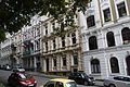
Nordstadt is the name for the area of the urban expansion that was built in the second half of the 19th century on the slope of the Wuppertal north heights , north of the city center of the then city of Elberfeld . Today one of the 69 statistical quarters of Wuppertal is so named. The north city is divided by the Hochstraße into the Ölberg district to the south and the actual north city north of it. The development is characterized by multi-storey apartment buildings in the style of historicism and the Wilhelminian era. The Elberfelder Nordstadt is one of the largest contiguous old building areas from the Wilhelminian era in Germany. The three large Elberfeld parishes also built new churches for the district during these years, in 1850 the Lutheran Kreuzkirche , in 1884 the Catholic Herz-Jesu-Kirche and in 1898 the Reformed cemetery church .
traffic
The northern part of the city is approached from the Elberfeld center with the WSW line 643, which ends at the “Lutherstift” stop.

New Friedrichstrasse
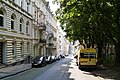
New north street
Row of houses on Neue Nordstrasse

Hermann von Helmholtz Realschule

Wilhelminian style residential buildings in Schreinerstrasse on the Mount of Olives


Individual evidence
- ^ Die Nordstadt - a special quarter in Wuppertal ( Memento from December 3, 2009 in the Internet Archive ), accessed September 2009
Web links

District 0 Elberfeld : 00 Elberfeld-Mitte | 01 Nordstadt | 02 Easter tree | 03 Südstadt | 04 Grifflenberg | 05 Friedrichsberg
District 1 Elberfeld-West : 10 Sonnborn | 11 Varresbeck | 12 Nützenberg | 13 Brill | 14 Arrenberg | 15 zoo | 16 Buchenhofen
District 2 Uellendahl-Katernberg : 20 Uellendahl-West | 21 Uellendahl-Ost | 22 Dönberg | 23 Nevigeser Strasse | 24 Beek | 25 corner bush | 26 Siebeneick
district 3 Vohwinkel : 30 Vohwinkel-Mitte | 31 Osterholz | 32 Tesche | 33 Schöller-Dornap | 34 Lüntenbeck | 35 Industriestrasse | 36 West Ring | 37 height | 38 Schrödersbusch
District 4 Cronenberg : 40 Cronenberg-Mitte | 41 Küllenhahn | 42 Hahnerberg | 43 Cronenfeld | 44 Berghausen | 45 Sudberg | 46 Kohlfurth
district 5 Barmen : 50 Barmen-Mitte | 51 Friedrich-Engels-Allee | 52 Loh | 53 Clausen | 54 Rott | 55 Sedansberg | 56 Hatzfeld | 57 Kothen | 58 Hesselnberg | 59 Lichtenplatz
District 6 Oberbarmen : 60 Oberbarmen-Schwarzbach | 61 Wichlinghausen-Süd | 62 Wichlinghausen-North | 63 NEXT BECK-East | 64 NEXTBreck-West
district 7 Heckinghausen : 70 Heckinghausen | 71 Heidt | 72 Hammesberg
District 8 Langerfeld-Beyenburg : 80 Langerfeld-Mitte | 81 Rauental | 82 Jesinghauser Strasse | 83 Hilgershöhe | 84 Löhrerlen | 85 Fleute | 86 Ehrenberg | 87 Beyenburg-Mitte | 88 Herbringhausen
District 9 Ronsdorf : 90 Ronsdorf-Mitte / Nord | 91 Blombach-Lohsiepen | 92 Rehsiepen | 93 Schenkstrasse | 94 Bloodfinches | 95 Erbschlö-Linde