Ōme
| Ōme-shi 青梅 市 |
||
|---|---|---|
| Geographical location in Japan | ||
|
|
||
| Region : | Kanto | |
| Prefecture : | Tokyo | |
| Coordinates : | 35 ° 47 ' N , 139 ° 17' E | |
| Height : | 187.5 m | |
| Basic data | ||
| Surface: | 103.26 km² | |
| Residents : | 133,824 (October 1, 2019) |
|
| Population density : | 1296 inhabitants per km² | |
| Community key : | 13205-5 | |
| Symbols | ||
| Flag / coat of arms: | ||
| Tree : | Crescent fir | |
| Flower : | Ume | |
| Bird : | Japanese Bush Warbler | |
| town hall | ||
| Address : |
Ōme City Hall 1 - 11 - 1 , Higashi-Ōme Ōme -shi Tōkyō 198-8701 |
|
| Website URL: | http://www.city.ome.tokyo.jp | |
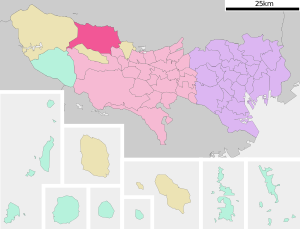
| Location Ōmes in Tokyo Prefecture | ||
Ōme ( Japanese 青梅 市 , - shi ) is a city on the middle reaches of the Tama in Tokyo Prefecture, west of Tokyo .
geography
Ōme is west of Tokyo and north of Hachioji . The Tama River flows through the city from west to east.
history
With the incorporation of the villages of Kasumi ( 霞 村 , -mura ) and Chōfu ( 調 布 村 , -mura ), the district town of Ōme ( district of West Tama ) became an independent town on April 1, 1951. In 1955 the villages of Yoshino ( 吉野 村 , -mura ), Mita ( 三 田村 , -mura ), Osogi ( 小 曽 木村 , -mura ) and Nariki ( 成 木村 , -mura ) were incorporated.
traffic
- train
- Street:
- National road 411
In Ōme-Railwaypark various historical rolling stock should be issued.
Town twinning
Sports
The Ōme marathon has been held in mid-February since 1967 .
sons and daughters of the town
- Masahiro Hasemi (* 1945), Japanese racing car driver
- Tsutomu Miyazaki (1962-2008), Japanese serial killer and cannibal
Neighboring cities and communities
Web links
Commons : Ōme - collection of images, videos and audio files


