Otisfield
| Otisfield | ||
|---|---|---|
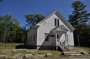
 Former town house |
||
| Location in Maine | ||
|
|
||
| Basic data | ||
| Foundation : | February 19, 1798 | |
| State : | United States | |
| State : | Maine | |
| County : | Oxford County | |
| Coordinates : | 44 ° 5 ′ N , 70 ° 33 ′ W | |
| Time zone : | Eastern ( UTC − 5 / −4 ) | |
| Residents : | 1,770 (as of 2010) | |
| Population density : | 17.1 inhabitants per km 2 | |
| Area : | 114.61 km 2 (approx. 44 mi 2 ) of which 103.42 km 2 (approx. 40 mi 2 ) is land |
|
| Height : | 205 m | |
| Postal code : | 04270 | |
| Area code : | +1 207 | |
| FIPS : | 23-55960 | |
| GNIS ID : | 0582655 | |
| Website : | www.otisfieldme.gov | |
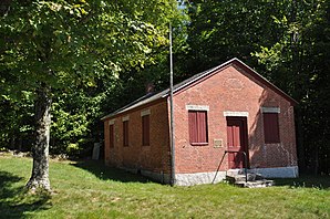
 Bell Hill School |
||
Otisfield is a town in Oxford County in the state of Maine in the United States . In 2010 there lived 1770 inhabitants in 1169 households on an area of 114.61 km².
geography
According to the United States Census Bureau , Otisfield has a total area of 114.61 km², of which 103.42 km² are land and 11.19 km² are water .
Geographical location
Otisfield is located in the southeast of Oxford County and borders on Cumberland County in the southwest . The Crooked River forms the border between the town and the county. The Androscoggin County is adjacent to the east. In the southeast is Thompson Lake and in the south of Pleasent Lake , other lakes in the area of the town are in the north of Moose Pond and Saturday Pond . The Little Androscoggin River flows south through Thompson Lake . The surface of the area is slightly hilly, the highest point is the 271 m high Scribner Hill .
Neighboring communities
All distances are given as straight lines between the official coordinates of the places from the 2010 census.
- North: Norway , 9.8 miles
- Northeast: Oxford , 5.3 mi
- Southeast: Poland Androscoggin County, 10.4 mi
- South: Casco , Cumberland County, 4 mi
- Southwest: Naples , Cumberland County, 6.8 mi
- West: Harrison , Cumberland County, 7.1 mi
City structure
There are several settlement areas in Otisfield: Bolsters Mills , Chambers Corner , Dunkertown , East Otisfield , Gould Corner , Oaks , Otisfield , Otisfield Gore , Rayville, and Wright Corner .
climate
The mean mean temperature in Otisfield ranges from −8.3 ° C (17 ° F ) in January to 20.0 ° C (68 ° F) in July. This means that the place is around 2 degrees cooler compared to the long-standing mean of Maine. The snowfall between October and May is well over two meters (with a peak in January of almost 50 cm) about twice as high as the mean snow depth in the USA. The daily sunshine duration is at the lower end of the range in the USA.
history
Land was granted by the Province of Massachusetts Bay in 1736 to Captain John Gorham and others for service in the 1690 Indian Wars. After the survey, it was found that these areas were mostly in New Hampshire and the grant was canceled. For this they were given replacement areas in 1771, which included the area of today's Town Otisfield and other areas. Among the beneficiaries of the grant was John Otis and after him the area was organized as Otisfield Plantation in 1787 and as Town Otisfield on February 19, 1798.
In the following years there were numerous changes of area. Phillips Gore joined in 1803. For the establishment of the Town Harrison 1805 and for the establishment of the Town Naples 1834 land was given up. More land was given to Naples in 1848. Parts of the Phillips Gore went to Oxford in 1830, and parts of the Thompson Pond Plantation were added in the same year. In 1858 parts of Poland were added and finally in 1933 an unorganized gore .
Population development
| Census Results - Town of Otisfield, Maine | ||||||||||
|---|---|---|---|---|---|---|---|---|---|---|
| year | 1700 | 1710 | 1720 | 1730 | 1740 | 1750 | 1760 | 1770 | 1780 | 1790 |
| Residents | 197 | |||||||||
| year | 1800 | 1810 | 1820 | 1830 | 1840 | 1850 | 1860 | 1870 | 1880 | 1890 |
| Residents | 450 | 912 | 1107 | 1274 | 1307 | 1171 | 1199 | 1099 | 927 | 838 |
| year | 1900 | 1910 | 1920 | 1930 | 1940 | 1950 | 1960 | 1970 | 1980 | 1990 |
| Residents | 728 | 632 | 581 | 568 | 488 | 599 | 549 | 589 | 897 | 1136 |
| year | 2000 | 2010 | 2020 | 2030 | 2040 | 2050 | 2060 | 2070 | 2080 | 2090 |
| Residents | 1560 | 1770 | ||||||||
Culture and sights
Buildings
In Otisfield, several structures have been listed and listed on the National Register of Historic Places .
- Bell Hill Meetinghouse , 2003 under registration no. 03000620.
- Bell Hill School , 2003 under registration no. 03000619.
- The Nutting Homestead , 1974 under the register no. 74000163.
- Otisfield Town House , 2005 under registration no. 05000055.
- Ryefield Bridge , 1999 under the register no. 99001193.
- Levi Sargent House , 1987 under registration no. 87000419.
Regular events
The Seeds of Peace Camp has been held regularly in Otisfield since 1993 . More than 6000 young people and carers from all parts of the world have so far met in the former Camp Powhatan to discuss conflict resolution strategies.
Economy and Infrastructure
traffic
The Maine State Route 121 passes through the southeastern part of the Town, partially along the West shore of Lake Pleasant Lakes and Thompson Lakes.
Public facilities
There are no hospitals or medical facilities in Otisfield. The closest are in Bridgeton, Norway and Auburn.
Otisfield does not have its own library. The closest are in Oxford, Casco and Harrison.
education
With Harrison, Hebron, Norway, Oxford, Paris, South Paris and Waterford, Otisfield belongs to the Oxford Hills School District also MASD17.
The following schools are offered in the school district:
- Waterford Memorial School in Waterford, school classes pre-kindergarten through 2
- Agnes Gray Elementary in West Paris, school classes pre-kindergarten to 6
- Harrison Elementary in Harrison, grades 3 through 6
- Hebron Station in Hebron, school classes pre-kindergarten through 6
- Otisfield Community in Otisfield, pre-kindergarten through 6
- Oxford Elementary in Oxford, school classes pre-kindergarten through 6
- Paris Elementary in Paris, school classes pre-kindergarten up to 6
- Guy E. Rowe Elementary in Norway, school classes pre-kindergarten up to 6
- Oxford Hills Middle School in South Paris, grades 7 to 8
- Oxford Hills Comprehensive High School in South Paris, grades 9 to 12
Web links
Individual evidence
- ^ Otisfield in the Geographic Names Information System of the United States Geological Survey , accessed February 2, 2019.
- ↑ Maine 2010 Census Results ; official publication of the Census Authority, (English; PDF; 32.5 MB)
- ^ Scribner Hill. In: peakery.com. Accessed February 2, 2019 .
- ↑ Coordinates of the locations of the Census Authority 2010
- ↑ a b c Otisfield, Oxford County | Maine Genealogy. In: mainegenealogy.net. Retrieved February 2, 2019 .
- ↑ a b Otisfield, Maine (ME 04270) profile: population, maps, real estate, averages, homes, statistics, relocation, travel, jobs, hospitals, schools, crime, moving, houses, news, sex offenders. In: city-data.com. www.city-data.com, accessed on February 2, 2019 .
- ↑ history. In: rootsweb.com. sites.rootsweb.com, accessed February 2, 2019 .
- ↑ Population 1790–2010 according to the census results
- ↑ Bell Hill Meetinghouse 03000620
- ↑ Bell Hill School 03000619
- ↑ The Nutting Homestead 74000163
- ↑ Otisfield Townhouse 05000055
- ↑ Ryefield Bridge 99001193
- ↑ Levi Sargent House 87000419
- ↑ About. In: seedsofpeace.org. Seeds of Peace, accessed February 2, 2019 (American English).
- ↑ Oxford Hills School District - Oxford Hills School District | Aude Suscipere Ausum. In: msad17.org. Retrieved February 2, 2019 .

