Rumford (Maine)
| Rumford | ||
|---|---|---|
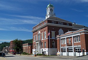
 City Hall |
||
| Location in Maine | ||
|
|
||
| Basic data | ||
| Foundation : | February 21, 1800 | |
| State : | United States | |
| State : | Maine | |
| County : | Oxford County | |
| Coordinates : | 44 ° 34 ′ N , 70 ° 38 ′ W | |
| Time zone : | Eastern ( UTC − 5 / −4 ) | |
| Residents : | 5,841 (as of 2010) | |
| Population density : | 32.9 inhabitants per km 2 | |
| Area : | 180.91 km 2 (approx. 70 mi 2 ) of which 177.54 km 2 (approx. 69 mi 2 ) is land |
|
| Height : | 368 m | |
| Postal code : | 04275 | |
| Area code : | +1 207 | |
| FIPS : | 23-64255 | |
| GNIS ID : | 0582703 | |
| Website : | rumfordme.org | |
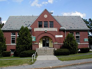
 Rumford Public Library |
||
Rumford is a town in Oxford County in the state of Maine in the United States . In 2010 there were 5841 inhabitants in 3287 households on an area of 180.91 km².
geography
According to the United States Census Bureau , Rumford has a total area of 180.91 km², of which 177.54 km² are land and 3.37 km² consist of water .
Geographical location
Rumford is in the east of Oxford County. The Androscoggin River flows east through the town's area. In the west, the Ellis River, coming from the north, flows into the Androscoggin River and in the east the Swift River . There are only smaller lakes in the town area. The surface is hilly and the highest point is the 715 m high Black Mountain .
Neighboring communities
All distances are given as straight lines between the official coordinates of the places from the 2010 census.
- North: Andover , 7.5 mi
- Northeast: Roxbury , 7.4 mi
- East: Mexico , 10.3 km
- Southeast: Peru , 18.2 km
- South: Milton , Unorganized Territory , 7.1 mi
- Southwest: Bethel , 16.5 km
- West: Hanover , 7 miles
- Northwest: Newry , 11.9 mi
City structure
Rumford has several residential areas: Abbots Mill , Bisbees , Littlefield , Mount Zircon , North Rumford , Porters , Rumford , Rumford Center , Rumford Corner , Rumford Falls , Rumford Point , Smith Crossing , South Rumford , Virginia and Woodrowville .
climate
The mean mean temperature in Rumford is between −7.8 ° C (18 ° F ) in January and 20.6 ° C (69 ° F) in July. This means that the place is around 2 degrees cooler compared to the long-standing mean of Maine. The snowfall between October and May is well over two meters (with a peak in January of almost 50 cm) about twice as high as the mean snow depth in the USA. The daily sunshine duration is at the lower end of the range in the USA.
history
The Grant to Rumford was given by Massachusetts to Timothy Walker and other associates of Concord , New Hampshire, in 1779 to compensate for losses they and their ancestors suffered during the Corcors- Bow dispute . First the area was called New Pennacook. The first settlers were Jonathan Keyes and his son Francis, who came from Massachusetts in June 1782. On February 21, 1800 Rumford was organized as a town.
Parts of Peru were added in 1895 and parts of Franklin Plantation in 1899. The rest of Franklin Plantation was taken by Peru.
In the eastern part of the Androscoggin River are the Rumford Falls, which have the highest drop in New England. About 3 miles above Rumford Point Village is a paint mine formed by sedimentation of a spring and red iron oxide. There is a significant deposit of iron ore nearby. Significant amounts of lead and graphite were found on a farm. Limestone is present in several places, most notably in Rumford Falls. In the Black Mountain Quarry, heterosite and cosnarite are mined.
Population development
| Census Results - Town of Rumford, Maine | ||||||||||
|---|---|---|---|---|---|---|---|---|---|---|
| year | 1800 | 1810 | 1820 | 1830 | 1840 | 1850 | 1860 | 1870 | 1880 | 1890 |
| Residents | 262 | 629 | 871 | 1126 | 1444 | 1375 | 1375 | 1212 | 1006 | 898 |
| year | 1900 | 1910 | 1920 | 1930 | 1940 | 1950 | 1960 | 1970 | 1980 | 1990 |
| Residents | 3770 | 6777 | 8576 | 10,340 | 10,230 | 9954 | 10,005 | 9363 | 8240 | 7078 |
| year | 2000 | 2010 | 2020 | 2030 | 2040 | 2050 | 2060 | 2070 | 2080 | 2090 |
| Residents | 6472 | 5841 | ||||||||
Culture and sights
Buildings
In Rumford, two districts and several structures and historic sites have been listed and placed on the National Register of Historic Places . The location of the historical sites is not disclosed.
- District
- Rumford Commercial Historic District , 2017 under registration no. 100000808.
- Strathglass Park District , 1974 under registration no. 74000181.
- Buildings
- Deacon Hutchins House , 1979 under registration no. 79000159.
- Mechanic Institute , 1980 under the register no. 80000241.
- Municipal Building , registered under no. 80000242.
- Rumford Falls Power Company Building , 1980 under registration no. 80000243.
- Rumford Point Congregational Church , 1985 under the register no. 85001259.
- Rumford Public Library , 1989 under the register no. 88003023.
- Strathglass Building , 1980 under registration no. 80000244.
- Town of Rumford Site , 1992 under registration no. 92001507.
- Historic sites
- Rumford Falls I-IV Site , 1992 under registration no. 92001513.
- Rumford Falls V Site , 1992 under registration no. 92001509.
Sports
The Black Mountain of Maine winter sports area offers a wide range of Nordic skiing disciplines. National competitions take place regularly in the winter sports area. In 1950, the Nordic World Ski Championships were held in Rumford.
Economy and Infrastructure
traffic
US Highway 2 runs parallel to the Androscoggin River on the north bank and crosses the town in a west-east direction. The Maine State Route 5 runs to the west of the area and follows the Ellis River in a southerly direction until it hits the highway. In a southerly direction, Maine State Route 232 branches off the highway . In the east, Maine State Route 120 branches off in a northerly direction .
The Portland – Island Pond railway runs through Rumford. Passenger traffic was discontinued on it, but freight traffic is handled over the route. The Cumberland Center – Bangor railway also runs through Rumford, as does the Rumford Junction – Kennebago railway . The Portland and Rumford Falls Railroad , Portland and Rumford Falls Railway and Rumford Falls and Rangeley Lakes Railroad are closed .
Public facilities
The Rumford Hospital is not only responsible for the residents of Rumford, but is also available to the residents of the neighboring towns.
The Rumford Public Library was founded in 1903. It was donated by Andrew Carnegie and built by John Calvin Stevens . The building is now a listed building.
education
Rumford belongs with Buckfield, Hanover, Hartford, Mexico, Roxbury and Sumner to the Western Foothills Regional School District (RSU # 10).
The following schools are offered in the school district:
- Buckfield Junior / Senior High School in Buckfield, grades 7 to 12
- Hartford-Sumner Elementary School in Sumner, school classes pre-kindergarten through 6
- Meroby Elementary School in Mexico, school classes pre-kindergarten to 5
- Mountain Valley Middle School in Mexico, grades 6 to 8
- Rumford Elementary School in Rumford, school classes pre-kindergarten through 5
- Mountain Valley High School in Rumford, grades 7 through 12
Personalities
sons and daughters of the town
- Charlie Akers (* 1939), cross-country skier and biathlete
- Jeb Bradley (born 1952), politician
- Frank Churchill (1901–1942), film music composer
- Edmund Muskie (1914–1996), politician, Governor of Maine, US Senator and Secretary of State of the United States
- Rodney L. Scribner (born 1935), politician, Maine State Treasurer and Maine State Auditor
Personalities who have worked on site
- Timothy J. Carter (1800–1838), politician
- Hugh J. Chisholm (1847-1912), entrepreneur
literature
- William Berry Lapham, The Library of Congress: History of Rumford, Oxford County, Maine, from its first settlement in 1779, to the present time . Augusta, Press of the Maine farmer, 1890.
Web links
Individual evidence
- ^ Rumford in the Geographic Names Information System of the United States Geological Survey , accessed March 7, 2019
- ↑ Maine 2010 Census Results ; official publication of the Census Authority, (English; PDF; 32.5 MB)
- ^ Black Mountain. In: peakery.com. Retrieved March 7, 2019 .
- ↑ Coordinates of the locations of the Census Authority 2010
- ↑ a b Rumford, Maine. In: mainegenealogy.net. Retrieved March 7, 2019 .
- ↑ a b Rumford, Maine (ME 04276) profile: population, maps, real estate, averages, homes, statistics, relocation, travel, jobs, hospitals, schools, crime, moving, houses, news, sex offenders. In: city-data.com. www.city-data.com, accessed on March 7, 2019 .
- ↑ a b History of Rumford, Maine. In: rays-place.com. history.rays-place.com, accessed March 7, 2019 .
- ↑ Population 1800–2010 according to census results
- ↑ Rumford Commercial Historic District 100000808
- ↑ Park District 74000181
- ↑ Deacon Hutchins House 79000159
- ↑ Mechanic Institute 80000241
- ↑ Municipal Building 80000242
- ^ Rumford Falls Power Company Building 80000243
- ↑ Rumford Point Congregational Church 85001259
- ↑ Rumford Public Library 88003023
- ↑ Strathglass Building 80000244
- ↑ Town of Rumford Site 92001507
- ^ Rumford Falls I-IV Site 92001513
- ↑ Rumford Falls V Site 92001509
- ^ Rumford Public Library Rumford, ME 04276 - Information and Services. In: me.us. www.rumford.lib.me.us, accessed March 7, 2019 .
- ^ Maine Area School District 39 School District in Buckfield, ME. | GreatSchools. In: greatschools.org. Retrieved March 7, 2019 .

