Pucusana district
| Pucusana district | |
|---|---|
 Location of the district in the province of Lima |
|
| Basic data | |
| Country | Peru |
| region | region free |
| province | Lima |
| Seat | Pucusana |
| surface | 37.8 km² |
| Residents | 14,891 (2017) |
| density | 394 inhabitants per km² |
| founding | January 22, 1943 |
| ISO 3166-2 | PE |
| Website | www.munipucusana.gob.pe (Spanish) |
| politics | |
| Alcalde District | Luis Pascual Chauca Navarro (2019-2022) |
| Political party | Alianza para el Progreso |
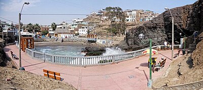
| The beach of Pucusana | |
Coordinates: 12 ° 29 ′ 6 ″ S , 76 ° 47 ′ 12 ″ W.
The Pucusana District is one of the 43 municipalities in the Lima Metropolitana Region in Peru .
The district has an area of 37.83 km². The 2017 census counted 14,891 residents. In 1993 the population was 4233, in 2007 it was 10,633.
geography
location
The Pucusana District is located on the Pacific coast in the extreme south of the Lima Province, 55 km south-southeast of Lima city center . It lies at an average of 7 meters above sea level. Pucusana borders on the Santa María del Mar district to the north and the Cañete province to the east and south .
climate
In Pucusana a temperate, maritime climate. The annual average temperature is 19.2 degrees Celsius, the annual rainfall is only 9 millimeters. August is the coldest month with an average temperature of 15.1 degrees Celsius, February is the warmest month with an average temperature of 27.5 degrees.
history
On January 22, 1943, Pucusana officially became a municipality of Lima.
politics
The incumbent mayor of the borough is called Luis Chauca Navarro (2019-2022)
tourism
Hotels
Most of the hotels are located in Pucusana.
Web links
- Municipalidad de Pucusana
- Peru: Region Lima (provinces and districts) at www.citypopulation.de

