
Sainte-Anne-sur-Vilaine
|
Sainte-Anne-sur-Vilaine Santez-Anna-ar-Gwilen |
||
|---|---|---|
|
||
| region | Brittany | |
| Department | Ille-et-Vilaine | |
| Arrondissement | Redon | |
| Canton | Bain de Bretagne | |
| Community association | Brittany Porte de Loire Community | |
| Coordinates | 47 ° 44 ′ N , 1 ° 49 ′ W | |
| height | 2-85 m | |
| surface | 28.57 km 2 | |
| Residents | 1,018 (January 1, 2017) | |
| Population density | 36 inhabitants / km 2 | |
| Post Code | 35390 | |
| INSEE code | 35249 | |
| Website | http://www.sainte-anne-survilaine.com/ | |
 Town hall of Sainte-Anne-sur-Vilaine |
||

Sainte-Anne-sur-Vilaine ( Breton : Santez-Anna-ar-Gwilen ; Gallo : Saentt-Ann-sur-Vilaèyn ) is a French commune with 1,018 inhabitants (as of January 1, 2017) in the Ille-et-Vilaine department in the region of Brittany . Sainte-Anne-sur-Vilaine belongs to the Arrondissement Redon and is part of the canton of Bain-de-Bretagne (until 2015: canton of Grand-Fougeray ). The inhabitants are called Saintanais .
geography
Sainte-Anne-sur-Vilaine is located about 43 kilometers south-southwest of Rennes on the Vilaine , which forms the western municipal boundary. Sainte-Anne-sur-Vilaine is surrounded by the neighboring communities of Guipry-Messac in the north, La Noë-Blanche in the northeast, Grand-Fougeray in the east, Pierric in the south and Langon in the west.
population
| year | 1962 | 1968 | 1975 | 1982 | 1990 | 1999 | 2006 | 2013 |
|---|---|---|---|---|---|---|---|---|
| Residents | 981 | 880 | 846 | 797 | 737 | 779 | 950 | 992 |
Attractions
- Sainte-Anne Church, built between 1832 and 1846
- Sainte-Anne chapel from 1940
- Port-de-Roche castle from the 17th / 18th centuries century
- Belle Mill
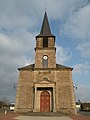
Church of Sainte-Anne

Chapel of Sainte-Anne

Poer-de-Roche Castle


literature
- Le Patrimoine des Communes d'Ille-et-Vilaine. Flohic Editions, Volume 1, Paris 2000, ISBN 2-84234-072-8 , pp. 648-651.