
La Chapelle-Bouëxic
| La Chapelle-Bouëxic | ||
|---|---|---|
|
||
| region | Brittany | |
| Department | Ille-et-Vilaine | |
| Arrondissement | Redon | |
| Canton | Guichen | |
| Community association | Vallons de Haute-Bretagne Community | |
| Coordinates | 47 ° 56 ′ N , 1 ° 56 ′ W | |
| height | 32-112 m | |
| surface | 20.66 km 2 | |
| Residents | 1,475 (January 1, 2017) | |
| Population density | 71 inhabitants / km 2 | |
| Post Code | 35330 | |
| INSEE code | 35057 | |
 Mairie La Chapelle-Bouëxic |
||

La Chapelle-Bouëxic is a municipality with 1,475 inhabitants (as of January 1, 2017) in Brittany in France . It belongs to the Department of Ille-et-Vilaine , the Arrondissement Redon and the Canton of Guichen .
The settlement area is approximately 80 meters above sea level. The Combs River runs along the southwestern municipal boundary . It borders in the northwest on Bovel , north to Baulon , in the northeast of Lassy (contact point), to the east by Guignen , to the south Mernel and to the west Maure-de-Bretagne .
Population development
| year | 1962 | 1968 | 1975 | 1982 | 1990 | 1999 | 2007 | 2013 |
|---|---|---|---|---|---|---|---|---|
| Residents | 712 | 656 | 629 | 599 | 670 | 809 | 1125 | 1366 |
Attractions
- Castle, Monument historique
- Saint-Joseph church, also a historic monument
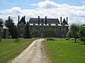
Castle of La Chapelle-Bouëxic
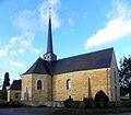
Saint Joseph Church

_%C3%89glise_02.JPG)
literature
- Le Patrimoine des Communes d'Ille-et-Vilaine. Flohic Editions, Volume 2, Paris 2000, ISBN 2-84234-072-8 , pp. 915-918.
Web links
Commons : La Chapelle-Bouëxic - Collection of images, videos and audio files