
Comblessac
|
Comblessac Kamlec'hieg |
||
|---|---|---|
|
||
| region | Brittany | |
| Department | Ille-et-Vilaine | |
| Arrondissement | Redon | |
| Canton | Guichen | |
| Community association | Vallons de Haute-Bretagne Community | |
| Coordinates | 47 ° 53 ′ N , 2 ° 5 ′ W | |
| height | 17-96 m | |
| surface | 17.23 km 2 | |
| Residents | 689 (January 1, 2017) | |
| Population density | 40 inhabitants / km 2 | |
| Post Code | 35330 | |
| INSEE code | 35084 | |
| Website | http://www.comblessac.com/ | |
 Comblessac Town Hall |
||

Comblessac ( Breton : Kamlec'hieg ; Gallo : Conbeczac ) is a French municipality with 689 inhabitants (as of January 1 2017) in the department of Ille-et-Vilaine in the region of Brittany . Comblessac belongs to the Arrondissement of Redon and is part of the canton of Guichen (until 2015: canton of Maure-de-Bretagne ). The inhabitants are called Comblessacois .
geography
Comblessac is about 39 kilometers southwest of Rennes . The Aff . Comblessac is surrounded by the neighboring communities of Guer in the north and west, Les Brulais in the east and northeast, Quelneuc in the south and east and Carentoir in the southwest.
| year | 1962 | 1968 | 1975 | 1982 | 1990 | 1999 | 2006 | 2013 |
|---|---|---|---|---|---|---|---|---|
| Residents | 641 | 581 | 535 | 489 | 497 | 487 | 588 | 714 |
Attractions
- Remains of a hexagonal Roman-Celtic temple, Monument historique
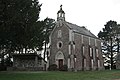
- Saint-Éloi church
- Saint-Conwoion Chapel
- Notre-Dame chapel in Lorette

Remains of the Roman temple complex

Saint-Éloi church
Notre-Dame chapel in Lorette


Personalities
- Conuvoion (around 800–868), Abbot of Redon, saint of the Roman Catholic Church
literature
- Le Patrimoine des Communes d'Ille-et-Vilaine. Flohic Editions, Volume 2, Paris 2000, ISBN 2-84234-072-8 , pp. 918-922.
Web links
Commons : Comblessac - collection of images, videos and audio files