Renac
|
Renac Ranneg |
||
|---|---|---|
|
|
||
| region | Brittany | |
| Department | Ille-et-Vilaine | |
| Arrondissement | Redon | |
| Canton | Redon | |
| Community association | Redon agglomeration | |
| Coordinates | 47 ° 43 ′ N , 1 ° 59 ′ W | |
| height | 2-94 m | |
| surface | 25.89 km 2 | |
| Residents | 1,009 (January 1, 2017) | |
| Population density | 39 inhabitants / km 2 | |
| Post Code | 35660 | |
| INSEE code | 35237 | |
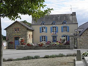
 Town Hall (Mairie) of Renac |
||
Renac ( Breton : Ranneg ) is a French municipality with 1009 inhabitants (as of January 1 2017) in the department of Ille-et-Vilaine in the region of Brittany . The municipality belongs to the Arrondissement of Redon and the canton of Redon of the same name . The inhabitants are called Renacois .
geography
Renac lies on the border with the Loire-Atlantique department . Renac is surrounded by the neighboring communities of Saint-Just in the north, Langon in the east, La Chapelle-de-Brain in the south-east, Avessac in the south, Sainte-Marie in the south-west, Bains-sur-Oust in the west and south-west and Sixt-sur-Aff in the north-west.
Population development
| 1962 | 1968 | 1975 | 1982 | 1990 | 1999 | 2006 | 2012 |
|---|---|---|---|---|---|---|---|
| 953 | 912 | 768 | 728 | 773 | 859 | 909 | 974 |
| Source: Cassini and INSEE | |||||||
Attractions
See also: List of Monuments historiques in Renac
- Saint-André church
- Les Buttes Saint-Julien mills, built in the early 19th century, monument historique
- Faubuisson Mill
- Le Brossay Castle from 1894
- La Touche Castle from the 17th century
- Le Petit Bois Castle
literature
- Le Patrimoine des Communes d'Ille-et-Vilaine. Flohic Editions, Volume 2, Paris 2000, ISBN 2-84234-072-8 , pp. 1190-1191.
Web links
Commons : Renac - collection of images, videos and audio files


