
Ercé-en-Lamée
|
Ercé-en-Lamée Herzieg-Mez |
||
|---|---|---|
|
||
| region | Brittany | |
| Department | Ille-et-Vilaine | |
| Arrondissement | Redon | |
| Canton | Bain de Bretagne | |
| Community association | Brittany Porte de Loire Community | |
| Coordinates | 47 ° 50 ′ N , 1 ° 33 ′ W | |
| height | 23-107 m | |
| surface | 39.21 km 2 | |
| Residents | 1,497 (January 1, 2017) | |
| Population density | 38 inhabitants / km 2 | |
| Post Code | 35620 | |
| INSEE code | 35106 | |
| Website | http://www.erce-en-lamee.fr/ | |
 Town hall of Ercé-en-Lamée |
||

Ercé-en-Lamée ( Breton : Herzieg-Mez ; Gallo : Erczaé is a) French municipality with 1497 inhabitants (as of January 1 2017) in the department of Ille-et-Vilaine in the region of Brittany . Ercé-en-Lamée belongs to the Arrondissement of Redon and is part of the canton of Bain-de-Bretagne . The inhabitants are called Ercéens .
geography
Ercé-en-Lamée is about 32 kilometers south-southeast of Rennes . The Semnon River forms the northern municipal boundary here. Ercé-en-Lamée is surrounded by the neighboring municipalities of La Bosse-de-Bretagne , Tresbœuf and Lalleu in the north, Thourie in the northeast, Teillay in the east, Ruffigné in the south, Saint-Sulpice-des-Landes in the southwest and Bain-de-Bretagne in the West.
population
| year | 1962 | 1968 | 1975 | 1982 | 1990 | 1999 | 2006 | 2013 |
|---|---|---|---|---|---|---|---|---|
| Residents | 1,668 | 1,542 | 1,356 | 1,253 | 1,145 | 1,156 | 1,318 | 1,517 |
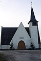
Attractions
- Saint-Jean-Baptiste church
- Saint-Fiacre chapel
- La Motte-des-Vaux castle from the 17th century

Saint-Jean-Baptiste church
Saint-Fiacre chapel


literature
- Le Patrimoine des Communes d'Ille-et-Vilaine. Flohic Editions, Volume 1, Paris 2000, ISBN 2-84234-072-8 , pp. 116-121.